There's been yet another mountain bike death this season, this time near Rocky Point, NY. Richard Olson, 49, was found dead on the trail next to his bike and police are investigating…
I've had the Oak Mountain State forest / BUMP trail near Birmingham, AL on my wishlist for quite a while now but after reading this I'm not sure how much longer I…
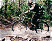
The Mercury News posted an article yesterday about the El Cerrito police department and their growing use of mountain bikes for patrol activities. Of course I've seen plenty of mountain bike cops…
There's an excellent article over on diylife.com on emergency mountain bike repair and some of the tips are probably ones you've never heard. My favorite: 'inflating' a flat tire by stuffing it…
In case you missed it earlier this week, USA Cycling announced the junior and U23 riders who will be competing in the 2008 UCI Mountain Bike World Championships in Val di Sole,…
There's a new mountain bike trail on Mt. Wellington in Tasmania (Australia) and according to legendary trail designer Glen Jacobs, "this is an amazing piece of hand-built engineering of unequalled workmanship." If…
I've been considering a 29er for my next mountain bike and I've been trying to read as much as I can online about others' experience with the larger wheels. I've even test…
This weekend I got the chance to check out a couple north Georgia mountain bike trails I hadn't ridden in a while so I thought I'd let you know what's up. We…
A few mountain bike gadgets and tech you may have missed this year: The RAM Mount: Want to take your GPS, cell phone, and PDA out on the trail but don't have…
CNN.com has an article on women's liberation and how things really got started with the bicycle back in the 19th century. The article mentions Jacquie Phelan, founder of the Women's Mountain Bike…
As you probably already know we're big fans of taking our GPS on the mountain bike trail, especially for keeping track of distance and climbing and for mapping new singletrack. This week…
Poison Oak Productions' latest documentary, The Way Bobby Sees It, follows blind downhill mountain bike racer Bobby McMullen's as he prepares to race the epic Downieville Downhill in California. From the Poison…
I read a couple good articles on mountain biking this morning: The Gear Junkie, Stephen Regenold, reviewed the D3O Armored L/S Crew and D3O Ultimate Chamois Bike Short from Spyder which is…
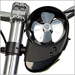
A bike-mounted charger uses wind to juice electronic devices.
Ferndale residents are pissed. A recent article in Mountain Bike Rider (UK) portrayed the village as a place "where everyone looked really unhealthy" and there was "litter cascading down the hill." A…
We put the Garmin Edge 605 cycling GPS to the test for mountain biking.
A couple items of interest today: Lance Armstrong is opening a bike shop in Austin, TX this month called "Mellow Johnny's," a reference to his nickname on the Tour de France (from…
I was reading a blog yesterday (which, oddly is gone today so I can't link to it) that was talking about modifying a mountain bike to make it a lean, mean, commuting…
Just a friendly reminder to get your tickets if you haven't already - the premier is this coming Monday, May 12! Tickets are just $15 in advance which gets you access to…
Mountain bike trail builders have always made the best of what's available but Kitsap MTB seems to have come up with a new one: the Tractor Tread. It's difficult to tell exactly…
Ray Ford posted a controversial piece for the Santa Barbara Independent calling for increased regulation of mountain bikes on Santa Barbara area trails. Ford seems to argue that bikes shouldn't be allowed…
I'm testing an Edge 605 GPS from Garmin right now and while I'm not ready to write a full review, I did want to share a cool feature you might not have…
If you're like me, you like to be prepared when you go out for a ride. What if you get lost on forest service roads and want to ask a redneck with…
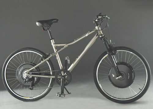
New mountain bike tech, circa 2008.
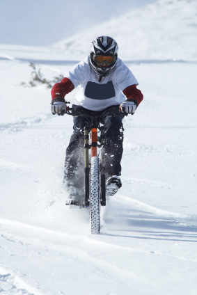
The Anchorage Daily News ran a story by Craig Medred a few days ago about winter riding in Alaska that had some good stuff in it. A few highlights: Snowmachine tracks are…
The guys over at Evomo are helping organize a fundraiser in memorial of Mark Reynolds, the racer who died at Sea Otter a couple weeks ago. Here are the details, please help…
In the past week or so there have been several stories of mountain bikers being injured and even killed while riding off road. Just last week a mountain biker was rescued near…
If you've been reading the news lately you know staple food item prices are way up: the price of corn, for example, has risen 30 percent in the last year. There seem…
If you don't feel like working yourself back into shape this spring, check out the E+ Mountain Bike from Electric Motion Systems (EMS). The E+ is pretty much a real mountain bike…
Over at the Daily Camera Marty Caivano posted an enthusiastic article about summer riding in the western US and runs through some of the biggest and best events being held this summer…
The Montery County Herald posted an article about pro mountain bike racers that gives a little insight into what it's like to live on your bike. Shonny Vanlandingham, Kelli Emmett and Lea…
Officials in Australia are cracking down on illegal mountain bike trails constructed within state forests and nature preserves with increased patrols and fines from $75 to $750. The EPA in Australia says…
The 13th annual Fruita Fat Tire Festival starts tomorrow which, in my opinion, means that spring has finally arrived everywhere. Last weekend the Californians got to play out at Sea Otter, now…
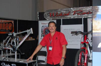
Mark Reynolds, owner of Wicked Racin and inventor of the Dualrailleur Guide, died suddenly during a race at the Sea Otter Classic this weekend at the age of 48. From eyewitness reports…
A couple of interesting mountain bike news items from the west coast caught my attention this morning: The San Francisco Chronicle posted an article on single speed mountain bikes that seems to…
There's a new mountain bike lifestyle clothing line on the block called Division 26 and Eric Carter, a pro rider for Mongoose, is on board to lend the brand some trail cred.…
It seems like mother nature is toying with the mountain bikers. One weekend the weather is beautiful and we're riding in shorts, the next weekend it's snowing and cold. Even here in…
Sounds like this will be a great event, see flyer for details.
When you combine bikes and beer you really can't go wrong, especially when the bikes are mountain and the beers are Sweetwater. The latest Collective film "Seasons" is being screened right here…
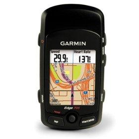
I just received an email from Amazon.com saying the Garmin Edge 705 is FINALLY available for purchase. Unfortunately they aren't giving these babies away but at least Amazon knocked $173 bucks off…
It's that time of year again - The Sea Otter Classic starts next week and this year's schedule appears bigger and better than ever. For those new to the sport, Sea Otter…
Mudhunny got me my first pair of real mountain bike shorts for my birthday this year - a pair of Fox Mid Ranger Shorts. I've always worn straight spandex on the trail…
Why does it seem like people are always trying to invent a better bicycle? The two wheeler has certainly seen some great innovations over the years (gears, suspension, etc.) but if you…
From DirtRag's Blog: Their 650B SantaCruz Heckler (Beckler) is finished... And it certainly looks sweet! This bike is equipped with a White Brothers 130 fork, RockShox Pearl shock, Velocity Blunt 650B wheels,…
The Bike Noob posed an age-old question on his blog yesterday: What's the difference between a mountain bike helmet and a road helmet? Well, obviously one often has a visor while the…
The mountain bike trails at Tom Brown Park in Tallahassee, FL aren't unlike the trails in many suburban areas - tightly packed loops that seem to fold in on themselves, multiple runs…
I'm glad to hear everyone enjoyed our April Fools post yesterday. For those who didn't read all the way through, Apple is NOT releasing an iBike, though a product called 'iBike' DOES…
In a bold move to dominate the growing mountain biking industry, Apple today announced the June 1, 2008 release of the iBike - a mountain bike integrated with an MP3 player, GPS…

 1
1