After discovering the Tanasi trails on the banks of the Ocoee river in Tennessee a few weeks back we were stoked to ride the Chilhowee trails right down the road on the…
Not many people know this but Labor Day was actually created as a holiday for mountain bikers back in 1882 so riders could get in one last epic ride before the end…
Yesterday the Calgary Herald published the inspiring story of Jay McCue, a part-time professional mountain biker who was paralyzed in a biking accident at Panorama Mountain Village in British Columbia two years…
Spoiler alert: Don't read this if you plan on watching the Jeep 48Straight coverage on CBS on September 28. The top mens and womens finishers from Diablo Freerider Park in New Jersey:…
IMBA is promoting its annual "Take a Kid Mountain Biking Day" on October 4 and you can register your group ride with IMBA. If you register your event before September 15 IMBA…
Photo: Paul Gilham / Getty Images / NBCOlympics.com The Olympics drew to a close this weekend but not before the Olympic mountain bikers had a chance to tear up the course at…
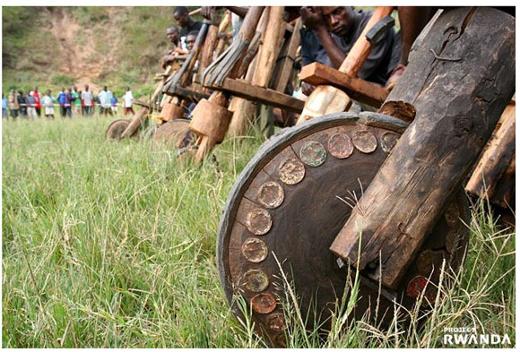
Have you heard about this? There's a great article in the current issue of Outside Magazine about how Tom Ritchey and others are trying to help people in Rwanda through cycling. One…
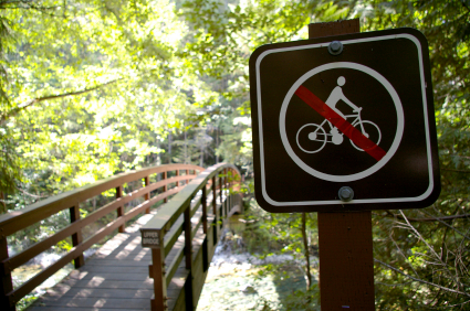
It seems mountain bikers may be wearing out their welcome at certain trails around the US this summer. In just the last 24 hours we've received requests from Virginia, Texas, and Georgia…
I could get used to watching BMX and mountain biking on television and fortunately there's more to come after the Olympic coverage this month. CBS Sports will be airing coverage from 3…
Giant Bicycles is opening a store in Santa Maria, CA in October called Cycle Star that will carry 90% Giant and Giant distributed bikes and accessories. This is the first store of…
We just got a couple t-shirts from the guys at Evomo and needless to say, we're stoked. Mudhunny and I both opted for the iconic 'Braincase' shirt but now we fight every…
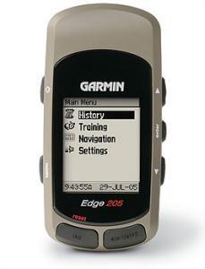
Just wanted to remind everyone of the contest happening this month. We're giving away a Garmin Edge 205 GPS to a randomly selected singletracks member who posts a new review on the…
Cannondale sponsored riders Roel Paulissen, Jakob Fuglsang and Kashi Leuchs will be racing a superlight, super-secret 8.8Kg version of the Scapel in the Olympic mountain bike event later this month. Whether the…
I came across this one in the current Springwise newsletter: A Dutch company is marketing stylish helmet covers for the venerable brain bucket. As you can see from the YAKKA diagram the…
I was reading an article in this month's Dirt Rag titled "Pedaling Democracy" and the author had this to say: Mountain bikers need to rally around a Ride to the Ride movement,…
Some readers asked about the Olympic MTB coverage after yesterday's post and EZ-E was nice enough to put together this list of cycling event times and television network information. Set your TiVo…
Photo courtesy AP Although the Olympic mountain biking competition is still 10 days away, the US Mountain Biker in Chief got a chance to check out the Laoshan Olympic Mountain Bike Course…
Photo: Mark Fox / AP Can you imagine what Dave Wiens must be feeling? The man beat Lance Armstrong on a bike this weekend but humbly kept it all in perspective: "The…
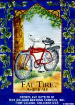
Since we're heading into the weekend some of you may be thinking - how should I carbo-load for tomorrow's epic mountain bike ride? The answer, my friends, is beer (assuming you're of…
How'd you like to see one of these out on the trail? Apparently this is a concept being tested by Trek in their own backyard of Madison, Wisconsin. The kiosk is actually…
Photo from Bike Academy For some reason this MTB article on ORF.at was titled "The Powder Snow of Summer" even though there was no mention of snow in the article itself. Either…
A few news items from the mountain bike scene last week: Eight riders fall ill after mountain bike race in UK The National Public Health Service for Wales is asking mountain bikers…
These days you don't see too many mountain bikers rocking clipless pedals from Look but the company is stepping up efforts to get back into the MTB market. Look actually invented the…
Just a quick heads up before we start the official promos: This month we're giving away a Garmin Edge 205 cycling GPS to one lucky reviewer on singletracks. Just submit a review…
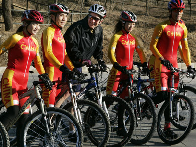
With the 2008 Olympics set to kick off in exactly one week I thought I'd talk about three of the mountain bikers that will be representin' for us in China. As you…
Looking for some songs to get stuck in your head for the next time you're out on the trail? Here are some recommendations: Weezer - Weezer (Red Album) The guys are back…
100km.us posted a couple good pics and links last week that you may have missed. via lifeinthefastlane.ca Yep, that's El Diablo, the crazy Tour de France dude, on top of an ENORMOUS…
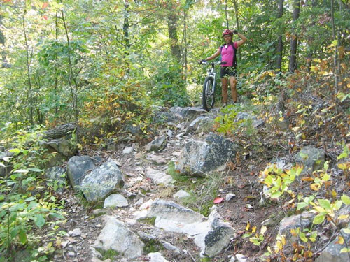
This weekend mudhunny and I drove up to the IMBA-certified EPIC Tanasi trails just over the Georgia border in southeastern Tennessee. The trailhead is located at the Ocoee Whitewater Center, site of…
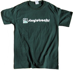
Yo yo yo! Just wanted to let you know we received a new shipment of singletracks t-shirts last week - our 4th or 5th printing (sorry, we lost track). This is great…
We wrote about mountain bike hunting last fall so I guess we should have seen this coming: mountain bike fishing. The Pittsburgh Post-Gazette posted an article about the phenomenon that's gaining traction…
The Shanghaiist had a good article about a group mountain bike tour outside the city of Shanghai near a "village" called Yiwu. If you think it's a hassle for you to get…
A few weeks back a friend and I were discussing big mountain bike jumps and how people learn to land them. I mean, we've all seen skills areas with progressively larger jumps…
These days folks are making holsters and mounts for just about everything you might want to carry on your bike: iPod, cell phone, GPS, lights, water bottles, tool bags, etc. One holster…
The Summit Daily News online has an article about a bill being prepared by Rep. Mark Udall that "would make it clear that activities like mountain biking, concerts and other appropriate uses…
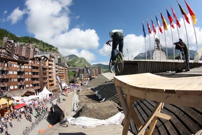
Coming on the heels of yesterday's post about the rooftop mountain bike expo in France, the Red Bull Roundup (this weekend, July 26 & 27) has a unique flavor all its own:…
Imagine this: It's the 1970s and 3 cops are on the roof of a Brooklyn apartment building chasing a frantic jewel thief. The thief runs to the edge of the building, bag…
Most stories we hear these days are about US mountain biking companies moving headquarters and production overseas but this time it's the other way around. Italian suspension maker Marzocchi is selling its…
The Jeep 48 Straight summer mountain bike event series was recently announced with stops at Diablo Freeride Park in New Jersey (!), The Canyons Resort in Utah, and Madonna Inn in California.…
A couple mountain bike videos to spice up your Thursday morning: 10,000 foot downhill Sacred Rides runs a MTB tour of the Olleros trail in Peru and they claim the descent is…
Comparing two options for tracking rides on a mountain bike.
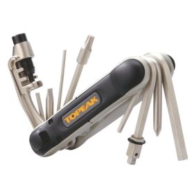
The LA Times print edition ran an article yesterday reviewing several trail-side mountain bike tools including the SRAM Power Link, Park Tool TB-2 Emergency Tire Boot, Topeak Hexus 16, and the Park…
The Wenatchee World Online posted a good article about mountain bike trails in Chelan County, Washington. Chelan County is about a 2 hour drive from Seattle and according to the article boasts…
Chris Jongewaard will be reconsidered for the Australian Olympic mountain bike team after he won an appeal against Cycling Australia, the country's governing body for the sport. Cycling Australia had barred Jongewaard…
Last week Rapid City hosted the National American Unicycling Championships and Convention and about 300 riders showed up to take part in the festivities. Many of the Rapid City locals specialize in…
A sampling of upcoming mountain bike festivals around the globe: Black Hills, South Dakota: The Terry Peak Mountain Festival will be held July 26 & 27 at the Terry Peak ski resort…
26inches.com is an Australia mountain biking forum and one of the bloggers, Mig Pilot, is a self-described 'fat guy' trying to get back on the bike. It sounds like the blog will…
What is it about mountain biking and documentaries that make them such a good fit? Perhaps it's because mountain biking is so real to us and we can spot mountain bike fakers…
This question was posed on an online forum recently and I thought it was a good one. Of course I'm a bit biased but I say the mountain bike is a better…


 2
2