

Over the past two days, I’ve shared what I believe to be three of the best city/state parks/open spaces for mountain biking, all of which reside in the mid-sized city of Colorado Springs. As great as those parks are, they are just that: parks, oases of rock and pine in the midst of urban development.
See Also: “Riding the Springs, Part 1: Palmer Park“
See Also: “Riding the Springs, Part 2: The Other Major Parks: Ute Valley and Cheyenne Mountain“
Adding to the variety that makes The Springs so special is the quantity and accessibility of backcountry type riding. The city directly abuts the Rocky Mountains, and from anywhere in the southwest quadrant of the urban area, it’s easy to hit any of a dozen trailheads, all accessing trails that rapidly disassociate themselves from the urban and become remote-feeling in very little time. More city open spaces like Red Rock Canyon, Stratton, and Bear Creek Park, all of which have quality singletrack in their own right, serve as gateways to over a hundred miles of backcountry adventure.

Orienting to Southwest Colorado Springs Riding
While all of these trails and open spaces can be connected, it’s easiest to think of the area as having northern and southern sections. The northern section has major trail heads at Red Rock Canyon Open Space, Palmer/Section 16, Bear Creek Regional Park, and High Drive. The southern sector is anchored by Stratton Open Space and a parking area at the confluence of Cheyenne Canyon, Gold Camp Road, and the southern terminus of High Drive. Gold Camp Road serves as a sort of backbone, which may be used to connect any of the trails listed here.

Gravel Grinding, Colorado Springs Style–SURF’S UP!!
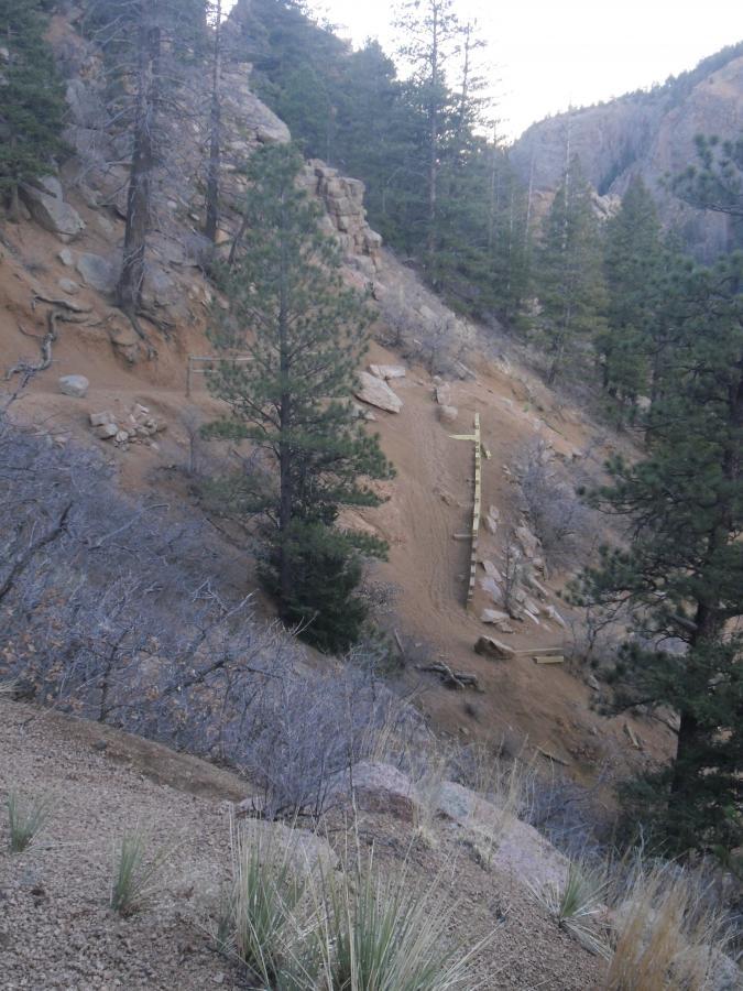
One complaint many put forward when riding here is the ubiquitous gravel that makes up the surface of so many of our trails. Unlike the limestones, sandstones, and shales that make up venues like Palmer Park and Ute Valley Park, the vast majority of the Pikes Peak Region rests on a bedrock of Pikes Peak Granite. This unique form of granite is naturally brittle and easily decomposes in the local climate, which goes through daily freeze-and-thaw cycles for a majority of the year. Large rocks become small rocks and small rocks become pea-sized gravel, sometimes inches deep. A rider used to firm or soft, but consistent, surfaces will find himself sliding a bit–if not completely out of control–when hitting a particularly pesky patch. A very aggressive tread , especially on the front tire, is very helpful. I’ll never forget my first-ever ride on a plus-size tire bike here–it was a revelation! But my main bike remains shod with aggressive 2.4s, and that’s more than adequate. It just takes some time getting used to.
Red Rock Canyon Open Space

One of the things the Springs is most known for is the Garden of the Gods, ranked by some as the number one tourist destination in America. While some trails there are open to bikes, the best ones are hiker-only, and there’s no real reason to take a bike to Garden of the Gods. However, just south of Garden of the Gods and US Highway 24 lies the Red Rock Canyon Open Space, which houses much of the same vivid red sandstone formations and vertical slabs rising over a hundred feet above the ground. This is a very popular rock climbing area, but also includes tremendous riding opportunities.
Many decry the relatively easy nature of most of the trails, but tough stuff is there to be found, especially as the trails get further from the parking lot, which also lies adjacent to a small skills park. The outer perimeter of the core park comprises one of the best, most varied, and scenic upper intermediate routes imaginable, while hidden nooks and crannies give everyone else a chance to play. For those looking for either more challenge or more mileage, the area provides access to the Paul Intemann Memorial Trail, running all the way into Manitou Springs, and the local love it/hate it trail, Section 16.
Palmer Section 16 Loop

This trail divides opinion like no other trail I’ve encountered, Slickrock included. The basic loop begins on High Drive, recently made vehicle-free (hooray!). Many decry having to start up a mile of dirt road at a 10-14% grade. Yes, it will most definitely get your heart rate up. But while it’s a wide dirt road, it goes up a deep, narrow, and scenically-spectacular (if you can lift your head up to look) canyon.

The next few miles are narrow singletrack on a more moderate grade, through a beautiful pine forest with occasional views of surrounding mountains that will make you completely forged you’re less than a mile from the city as the crow flies. But it does spend a good deal of time on that dreaded gravel, which seeks to suck the life out of the legs of anybody who hasn’t yet made peace with it.
Then comes the descent.
Steep, loose, rocky, tight, switchbacky, etc. It will throw a bit of everything, including heavy gravel surf, at you. Even among riders who like technical challenge, they will make a distinction between fun-technical and annoying-technical. Here’s where more of the debate comes in. Many say Section 16 is annoying-technical, while I find it to be fun-technical. I encourage you to come and find out for yourself!
Stratton Open Space / The Chutes

Further southwest lies a Colorado Springs classic: The Chutes. The Chutes sits as the uppermost trail segment atop the many popular trails in the Stratton Open Space. The Chutes is a bobsled run for bikes, a high-speed blur of yankin’ and bankin’, a sort of Kessel Run in the pines. It is as well-known and frequently ridden as Palmer Park. While that plunge makes for a positively scream of a downhill, it is at a gentle enough grade to make for a marvelous training climb. The local high school even uses it as a training run for its cross country team. Given it’s excellence as a both a climb and a descent, I’m surprised there isn’t more conflict; it seems like the perfect breeding ground for Stravassholes. But everyone has learned to take it all in stride, and we all get along just fine.
Buckhorn / Captain Jack’s

Captain Jack’s is yet another classic. How classic is it? When Singletracks published an article asking various pros what their favorite trail was, none other than mountain biking pioneer and legend Joe Breeze listed Captain Jack’s as his choice. Jack’s is moto-legal, which adds to the gravel production, so be prepared for a few miles of high speed surfing over varying degrees of steepness, interspersed with some solid rock, quick, sharp climbs, and moto-induced whoop-de-dos. Those who ride the whole thing clean invariably finish with a permagrin that doesn’t dissipate easily.
But of course, what goes down, must first go up, which is where Buckhorn comes in. Steep and gravelly, with a few very tight switchbacks and many large (by Colorado standards) roots, Buckhorn is much like the Palmer climb to Section 16 mentioned above–just steeper and with more obstacles. For the fit, it’s a marvelous climb.

Columbine and Points Above
Below the Buckhorn/Jack’s complex lies the very unique Columbine Trail, which can either be accessed just above the pullout to the popular Helen Hunt Falls (named for a local 19th century poet and activist, not the star of Twister), or in a far more fun way, via the short Spring Creek trail, which starts just across Gold Camp Road from the bottom of Captain Jack’s. Spring Creek is a fun little romp through a ponderosa forest that actually avoids the gravel for a while.
Shortly after joining Columbine, it’s back on the gravel on a narrow side cut, hanging hundreds of feet above the floor of Cheyenne Canyon. It is a genuine wonder to behold with the eyes, but you will need to keep your eyes squarely on the trail! Even steeper and more gravelly than Jack’s, I don’t recommend doing this one as an uphill. Once completing the downhill, it is easy to connect over to the Stratton Open Space, completing a variety of loop options.
Lying well above the other trails are some lesser-known, but well-worth-seeking routes. St Mary’s Falls is another steep gravel fest, with a very nice waterfall as its usual destination and a very fun romp back down. Some may choose to keep climbing well into the high country, to make a loop with other area trails.
For those who don’t relish such a heinous climb, it is possible to shuttle, via the Old Stage Road (this part of Gold Camp Road is closed to automobiles), to the area’s premier downhill, the Pipeline Trail. This is truly a day-long, high-mileage endeavor when ridden as a loop, and still a solid half day as a shuttle. Unfortunately, the Jones Park descent and part of Bear Creek Canyon have been closed to protect the Greenback Cutthroat Trout, but there is still a totally rad finish to be had by descending the Seven Bridges Trail. Just be aware that Seven Bridges is probably the single most popular hiking trail in the area, so it’s best to do this on a weekday if possible.

After the Ride
From the north sector, it’s hard to beat Rudy’s Barbeque, especially since it sits right at the base of Red Rock Canyon and no vehicle is necessary to get there from your ride. Just a short distance away is unique but excellent Mexican at Amanda’s Fonda, a real treat if you can get an outdoor patio table next to the creek. Also nearby is the Colorado Mountain Brewery, housed in a refurbished roundhouse from the old narrow-gauge railroad days.

From the south sector, the recommendations are the same as yesterday’s references following a ride at Cheyenne Mountain State Park, especially Bristol Brewing in the old Ivywild School.


3 Comments
Nov 6, 2016
Jul 9, 2016
Jul 11, 2016
My favorite route is from my house one block to Bear Creek Park, up the Regional Trail to the connector to Gold Camp Road. Down Stephanies (in upper Bear Creek Park), up Gold Camp Road all the way to Buckhorn to Jack's. At the bottom of Jack's cut across to Spring Creek to Columbine. Down Columbine to the bottom, over to Stratton, up to Chamberlain to Chutes. Back down the Chutes and Chamberlain over to just above Gold Camp Elementary and the streets back home.
23 miles, 3,800 ft of climbing. I don't do it nearly as often as I used to!