This weekend I got a chance to check out the Dauset trails south of Atlanta and I think I'm impressed. I mean, just looking at the stats - ~17 miles of wooded…
Recently, I was listening to our local talk-radio station and the host, Russ Johnson, had commented on the difficulty in being able to find products that are still made in the USA.…
That's according to Bicycle Retailer but I'm thinking perhaps the Tour de France is a bit larger. Bicycle Retailer claims Sea Otter hosts around 10,000 competitors and 50,000 fans but I know…
Earlier this month the US Library of Congress got their heads out of their asses and updated the subject "All Terrain Cycling" to "Mountain Biking" in their extensive catalog system. Perhaps they…
Lance raced the Miles of DisComfort Mountain Bike Marathon Event at Flat Rock Ranch in Texas this past weekend and apparently the competition was a bit too much. Armstrong dropped out of…
Congress is introducing the West Virginia Wilderness Bill next week and according to the West Virginia Mountain Bike Association (WVMBA) it could spell the end of bike access to more than 50…
If you're thinking about heading to Shawnee Peak Ski Area in Bridgton, Maine this weekend, skip the skis - bring your mountain bike instead! Ernie's Cycle Shop Snow Mountain Bike Race will…
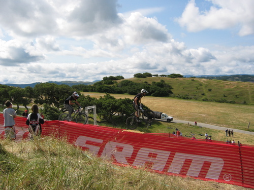
Ever wonder how people get into doing those 24-hour mountain bike races? I mean, plenty of people participate in 24-hour races as a part of a team but you gotta be made…
What better way to show your French pride on the road or trail than with a bike helmet shaped like a beret? A young artist in Czechoslovakia has designed just such a…
I hate to keep reminding everyone that it's the winter but it seems like all the MTB news these days just confirms it. You know the weekend ride in Macon I skipped…
Yeah, I chickened out this weekend. I mean, I had every intention of going down to Macon Saturday to the SORBA mountain bike weekend but then they said the white stuff was…
For some folks the upcoming 3-day weekend will be a good chance to hit the slopes but here's another idea: Give back to your local trails. Students at the University of Washington,…
Peter Lynch, the legendary Fidelity mutual fund manager and investment guru, always recommended investing in what you know to achieve extraordinary financial returns. If you're like me you know about mountain biking…
New USA Cycling Mountain Bike Coach: Mike "Gully" Gullickson took over both the mountain bike and cyclo-cross programs for USA Cycling yesterday. Gullickson brings serious dirt racing experience as a five-time UCI…
SORBA is hosting a big bash down in Macon, GA this weekend that promises to rival any of the big summer MTB festivals. Camping Friday and Saturday night, a tour of the…
From IcWales.co.uk "A WELSH town will be transported back into Roman times today as it aims to maximise its visitor appeal. Residents in Llanwrtyd Wells--the self-confessed "wacky capital of Wales"--will don togas…
Lee McCormack brought up an interesting question over on his blog yesterday: Why do high end mountain bikes often cost more than high end motorbikes (dirtbikes)? Are mountain bikers being given the…
Lest you think the Consumer Electronics Show in Vegas this week is all about flat screen televisions and geeky computer junk, here are a few products being exhibited that even mountain bikers…
I just read a quick article about a guy who is riding a mountain bike across Asia. He started near the base of Everest and has been riding since last April. Not…
In the past mountain bikers have received a bad rap for damaging the environment and in all honesty, our reputation hasn't been entirely undeserved. Trails were often constructed with little consideration for…
San Rafael, Calif. - January 8, 2008 - Trips for Kids (TFK) proudly announces its annual "Brews, Bikes and Bucks" raffle event will take place Sunday, February 10, 2008 at the Broken…
Looking for a way to stick to your mountain bike resolutions in 2008? Here's one way: Commit to riding in an epic mountain bike event this year. (Notice I didn't say you…
I came across a couple of interesting tidbits of mountain bike news this morning that you may have missed as 2007 came to a close: * What do you get the man…
If you're just now getting into texting on your phone I hate to tell you but you're way behind the times. These days you can do a whole lot more and you…
So I have this New Year's tradition that I started four years ago and haven't kept since: A New Year's day mountain bike ride. Yesterday that tradition was revived at the Stonewall…
Christini has developed an AWD bike with 5/6" of travel, after having produced the 4" travel Venture for some time now. Known simply as the Christini Long Travel, it is available as…
Ever wonder what happened to your favorite mountain bike brands from the 1990s? Thanks to the internet you don't have to wonder any more - a trip down memory lane is just…
From the Pocono Record December 31, 2007 "Looking for a challenge? How about downhill mountain biking on a black-diamond ski slope? "Blue Mountain Ski Slope is readying for its annual Bikercross. This…
Mountainbikes have run with the 26" wheel for a long time, and not because it was the best; but because it was the only size that the first fat-tire riders could use…
Want to know what's in store for mountain biking in 2008? My crystal ball tells me 2008 is going to be the year of the mountain bike as we see these developments…
As 2007 comes to a close I thought I'd reflect on some of our more popular blog posts and in a separate post I'll give my predictions of the top mountain biking…
Too Much Fun Promotions is hosting the first Baja Epic mountain bike race in Baja California, Mexico November 5-8 starting in Rosarito Beach. The challenging course promises diverse terrain through some very…
Okay so this will probably appeal to roadies more than anyone else but Cervellum has a prototype for a rear-view video camera and handlebar display unit. Though the cam is way cooler…
Around this time of year many folks start considering their health and fitness goals for the new year so I thought I'd share some thoughts on mountain biking for fitness. If you've…
The title of this blog article is a little misleading. Biopace chainrings and chainstay v-brakes were fads. This development has proven itself to have immense staying power. Already, the 650b/27.5" wheel phenomenon…
Singletracks experienced some minor technical problems earlier this week (that is, if you consider your server catching fire and melting "minor") but we're back in business with a shiny new motherboard and…
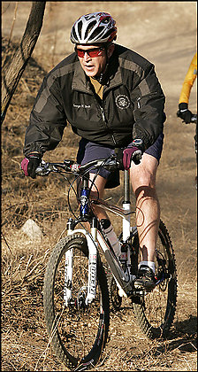
President Bush is a fat tire junkie and the Washington Post printed an article on Monday that offers some dirt on the who and where of the President's mountain bike rides. Apparently…
Marilyn Price, founder of Trips for Kids, a non-profit that helps disadvantaged kids experience the excitement of mountain biking, is one of 40 finalists to be named "America's Hometown Hero" in the…
How do you convince intelligent, fun-loving high school seniors to apply to your conservative Christian university near Lynchburg, VA? You build some gnarly mountain bike trails on campus, of course! At least…
steve32300 recently posted about a new mountain bike trail in Fruita called Free Lunch and I've just received more dirt via IMBA and the BLM. Apparently the trail is the first purpose-built…
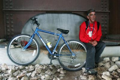
A homeless man in Austin is getting a new mountain bike for Christmas this year thanks to the generosity of local residents. Bicycle Sport Shop, owned by recent mountain bike hall of…
Gary Fisher gave an interview over at Cycling News about what he sees as a "second coming for mountain biking" that's going on right now. As one of the fathers of mountain…
The internal-geared hub has been around for decades, commonly found on city-cruisers & touring bikes. They're nearly impervious to dirt & water; have a robust construction, and are available with a wide…
Bicycle Retailer reports a few bike manufacturers and retailers got scorched in the recent California wildfires though it sounds like for most it's back to business as usual. The folks at Ellsworth…
If you could pick the 3 best mountain bikes on the planet, which ones would you choose? Apparently 3Luxe, which claims to help you find "the best of everything," thinks you should…
A couple college kids studying industrial design built this mountain bike / motorcycle hybrid that looks absolutely gnarly. Everything about it screams mountain bike - from the tires to the handlebars -…
Recently, a fairly revolutionary bike was released that seems to have pushed the use of carbon-fiber in mountainbikes to a level unseen as of yet. This design will surely raise a great…
Okay so this isn't a gadget blog and GPS is really only a mountain bike accessory but I had to write about the newest outdoor unit from Magellan. The Triton 2000 is…


 1
1