I listened in on a demo of the Edge 705 from Garmin this afternoon and there were a few features I hadn't heard or read about before. The Edge 705 incorporates ANT…
The GoPro Helmet Hero looks like a sweet choice for all your helmet cam needs. The Hero can record almost an hour of footage on a single 2Gb SD memory card with…
If you're like me you're not a big fan of the Camelbak or similar backpack mounted hydration system. I mean it's heavy, bulky, and hot when you're riding and it just tends…
Now this is something I couldn't have imagined: using inflatable balls to pump up a bike tire. Now apparently this has been done for some time with motorcycle and dirt bike tires…
Dontcha hate it when your chain falls off after a gnarly downhill? Of course you could go with a derailleur guide but that usually limits you to a single chain ring on…
The Wounded Warrior Project was set up here at Interbike and I got the skinny on some of the cool stuff they're doing for injured Iraq and Afghanistan Vets. Their mission is…
I spoke with a rep from Carver Bikes about the newest new thang in big wheel bikes: the 650B. Of course Carver is known for their rad titanium framed 29ers and 96ers…
Recent IMBA release: Can you believe mountain bikers are still treated as second-class citizens? First, we were accused of speeding erosion. Then, we were labeled a "dangerous menace" and kept at bay…
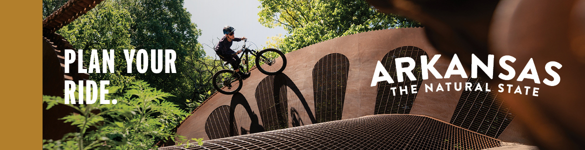
Interbike kicks off today with the 2-day Outdoor Demo portion in Bootleg Canyon, NV. I'll be heading out to Las Vegas tomorrow to catch the opening of the indoor portion bright and…
Anthony Blasioli was attacked by a bear during a mountain bike ride earlier this month in Banner Forest Heritage Park in Washington state but luckily, he survived. Blasioli credits prayer and his…
Hannah Nordhaus wrote an article for the Rocky Mountain News website a couple days ago about the new paved bike loop in Leadville, CO where she waxed poetically about the virtues of…
If you're in southern Virginia, NC Triad or NC Triangle area, this concerns you! Potential for a huge trail system just up the road, read on to find out more. The Philpott…
The Garmin Edge GPS series has been our favorite choice for mountain biking for a while but we've been frustrated with the ability to import and export data using Garmin's Training Center…
IMBA has come out with a method for rating mountain bike trail difficulty in the book Trail Solutions: IMBA's Guide to Building Sweet Singletrack. It's called the IMBA Trail Difficulty Rating System…
We've profiled several towns and regions around the world from Israel to Scotland to the US who hope to revive local economies through bike tourism. But does this ever work and how…
Watch out bike thieves - GPS bike tracking shows up again! This time it's at the University of Toronto and the bikes being tracked are actually "bait bikes" placed around campus to…
Forget about track stands and bunny hops - check out what this guy can do! You may have seen this or similar vids already but I never get tired of seeing this…
Tara Llanes suffered serious injury after a bad crash at the Jeep King of the Mountain race at Beaver Creek on September 1. Tara landed on her head and back and she's…
Allentown is hosting a slew of bike races on Sunday including the first ever Tour de Brew Fat Tire Crit. Competitors will ride through a bar/restaurant from back to front as patrons…
The Rocky Mountain News had a good article yesterday on the growing popularity of Women's only mountain bike clinics. They talk about how to choose the right clinic and even list a…
I've had fond memories of Bull Mountain over the past 8 years and Monday I decided to see how my memories compared to reality. We got up to the trails early and…
I'm heading to Interbike next month and I'm completely pumped like a fat tire at 60psi. The trade show is being held Sept 26-28 in Las Vegas and it's by far the…
The Santa Cruz Sentinal had an article about a 50-year-old couple who suffered severe injuries after riding off an 80 foot cliff in the Forest of Nisene Marks State Park in California.…
The OC Register had an article yesterday that mentions how an injured mountain biker was rescued thanks to his trusty GPS and cell phone. Devon Kemp was mountain biking on the San…
Mudhunny forwarded me this interesting article from the Washington Post about busting bike thieves in the DC area. It turns out bike thieves are becoming more discerning in seeking out high end…
This weekend mudhunny and I rode at the Georgia International Horse Park (GIHP) trails in Conyers, GA (ya know, the 1996 Olympic mountain bike course) and had a blast. The trails weren't…
A new mountain bike trail is being developed around Lake Kinneret in Israel that, when complete, will be more than 114 kilometers (about 71 miles). Like alot of new trail development these…
The Jeffersonian ran a good profile yesterday on Chris Eatough, 4-time National and 6-time World 24-hour solo mountain bike champ. As you may recall Eatough is the star of the documentary 24…
There are new downhill mountain bike trails at SolVista Ski Resort near Winter Park in Colorado and this summer it's free to ride the lifts on weekends! The trails are getting rave…
When I moved back to the flatlands of the southeast a couple years ago I found it odd that mountain bike trails had difficulty ratings. Some ratings were official (like the beginner…
We're finally getting settled into our new Atlanta digs and mudhunny and I managed to squeeze in a ride at Yellow River yesterday. The trailhead area has seen major upgrades since the…
I came across a couple articles yesterday about new mountain bike trail projects under consideration near Asheville, NC and Roanoke, VA that sound promising. In both cases, though we hear the same…
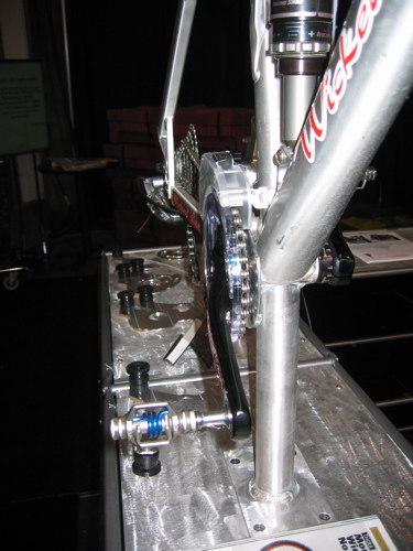
Lennard Zinn has an interesting article over on Velonews this week where he looks back at some of the advancements in bike tech over the past 25 years. I have to admit…
While skiing this past winter I had a morbid question on my mind: do more people die in skiing related accidents or mountain bike accidents each year? One article I read in…
In case you've been completely disconnected like me, Floyd Landis took second place in the Leadville 100 mountain bike race in Colorado this weekend. He actually had a pretty good performance -…
I really thought the news was too good to be true. A couple weeks ago we read that Lance Armstrong AND Floyd Landis would be racing in the Leadville 100 mountain bike…
Terry Pearson posted a few days ago about cycling induced heat stroke and with record heat across the country this week it's a great time to remind people about the dangers of…
Sorry about the lack of news over the past week or so. We're on the move from our digs in Durham, NC to a new spot in the Atlanta area and it's…
There's been alot of talk and high-fiving around the Mountain Bike Oregon weekends and I have to say, I don't get it yet. I mean, I have heard that it's fun and…
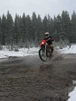
I meant to post a short tidbit last week about a collision between a mountain biker and motorcyclist near Telluride but never got around to it. Ellen Hollinshead mentioned it in her…
Investor's Business Daily (seriously) did a great profile on Gary Fisher yesterday in case you missed it. The article gives a solid history of the sport and talks about how Fisher was…
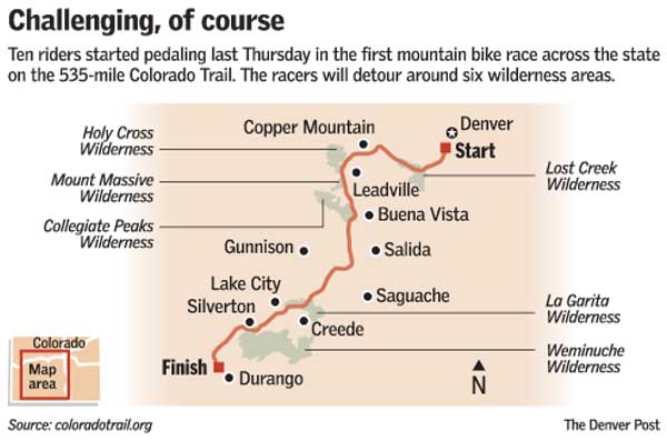
How come no one told me about this? On June 13th 10 mountain bikers set out on a 535 mile race along the Colorado Trail from Waterton Canyon near Denver to Durango…
After hundreds of mountain bikers at the Test of Metal mountain bike race fell ill last month a doctor says race organizers should have cancelled the event. "Our future advice to the…
If you haven't been following Le Tour, there's a mountain biker in the yellow jersey - Michael Rasmussen. Rasmussen is a former mountain biking world champion and more recently, an alleged doper.…
Biking Bis is claiming that Lance Armstrong is planning on riding in the Leadville 100 on August 11 after all - despite previous news that Armstrong had a "scheduling conflict." The post…
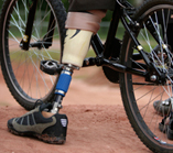
Think mountain bike racing is extreme? Try mountain bike racing with an artificial limb! The O&P Extremity Games kick off today in Orlando, Florida for athletes with "limb loss or limb difference."…
A British mountain bike tour guide with Endless Ride was arrested for leading a group of British mountain bikers in the Morzine area without the proper "French qualification." Apparently French guides in…
IMBA has a new program that lets you represent IMBA at epic mountain bike races starting with 24 Hours of Moab this fall. IMBA gives you the tools to raise funds to…


 1
1