I noticed an interesting new map view on Google Maps when searching for directions the other day: Terrain. Up until now Google Maps has been a pretty bad choice for mapping mountain…
No one can accuse singletracks members of having cheap tastes: This year's holiday wish list contains some of the best equipment money can buy. From GPS units to navigate the trail to…
The Guardian has an in-depth article about the transformation going on at Raleigh these days and it's pretty interesting from a business perspective. Personally, I didn't realize: Raleigh is a British company…
Now I've heard it all. Apparently hunters in Montana (and I assume other places as well) are ditching ATVs and pickup trucks in favor of mountain bikes in pursuit of the kill.…
Okay, so that's not the official name of the trail - but development of the Slaughter Pen Hollow Mountain Bike Trail in north Bentonville, Arkansas is being driven by some heavy hitters,…
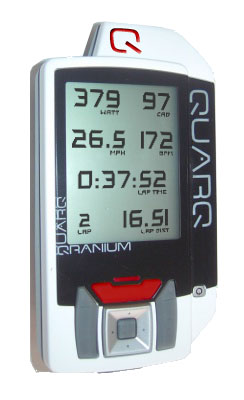
Quarq announces a new GPS for cycling.
After more than a few years worth of experimenting, debating, and magazine reviewing; the 29'er is here to stay. The 29"-wheel has become the Super Swamper of mountainbiking. Almost every major bike…
Stage 3 of the 4-stage La Ruta mountain bike race is taking place today in the steamy jungles of Costa Rica and from what I've read this could easily be the world's…
Recently unearthed by one of Mountainbiking's forebears, Charlie Kelly; CK's Mountainbiking Hubsite is a treasure trove of visual history, interesting anecdotes, and commentary. And going beyond the typical bike "porn" movies laden…
The Marin Independent Journal posted an article yesterday about Steven Gravenites and his fight in federal court over a $60 fine for riding an illegal bike trail. The entire series of events…
Apparently mountain bikes carry a lot more than just mountain bikers - your bike could be spreading invasive plant species! At least that's what a 17-year old New Zealand student found -…
When mudhunny and I left Colorado just over three years ago we knew our opportunities for riding incredible mountain bike trails were limited. Since that time we've ridden some good trails but…
In the history of Mountainbiking, there have been more than a few women who have made huge impressions on the sport, both in the beginning and currently. Wende Cragg, Jacquie Phelan, Juliana…
If you're a regular reader of this blog you may have noticed an unusually well written piece yesterday about returning bike tech to simpler times. No, I didn't suddenly learn all there…
Employees from 3 outdoor companies are set to work on a new trail in Boulder County, CO tomorrow to connect trails at Hall Ranch and Heil Valley Ranch. Timberland, Go Lite, and…
I regularly pick up nearly every mountainbiking rag, covering both the US and UK cycling scenes. And the coverage of the major industry events & product releases has increasingly focused on the massive advances…
The guys over at BlueCollarMTB.com posted a complaint a couple days ago about the 2008 National Mountain Bike Series calendar and the fact that only 1 out of the 6 events is…
I just came across a great ride report on the Grande Route of Historical Villages in Portugal over at Go Nomad. The 335 mile bike route was laid out in 2000 and…
I never would have thought that November would be ideal mountain biking weather in Alaska but apparently it is. Since much of the Alaskan wilderness is a swampy bog during the short…
Hueston Woods in Ohio is hosting a mountain bike trail weekend next week at the park to raise awareness for trail maintenance and improvement. IMBA will be in town as part of…
I recently found a mountain bike blog called Sacred Rides Mountain Bike Holidays and they've posted some good stuff recently. The first post I really enjoyed was about Bikes Without Borders, a…
Ok, so if you've been mountain biking more than a couple times you've probably seen or heard the rule that mountain bikers yield the trail to hikers and equestrians. Well at one…
What happens when you combine ultimate frisbee with mountain biking? You get MTBU, a franken-sport being played in grassy fields since it's invention in 1990. I had personally never heard of it…
From the current issue of Wired magazine. EXPIRED: Recumbents TIRED: Fixies WIRED: 29ers I'm sure there are a lot of geeks scratching their heads right now. Those of us on the bleeding…
The crew that's riding their mountain bikes from Prudhoe Bay, Alaska to Tierra del Fuego at the tip of South America is still on the trail and they recently reached the halfway…
I wrote back in June about a problem I was having with my Edge 305 freezing up on rides and in case you're curious the problem continued through the summer (though it…
Although mountain bikers have been riding the trails in Cleveland Metroparks' Ohio & Erie Canal Reservation in Cuyahoga Heights for years, it was never officially sanctioned: until now. Last month Cleveland Area…
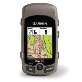
Bad news if the Garmin Edge 605 or 705 is on your Christmas list: The new Edge GPS units won't be shipping until the first quarter of 2008. GPS Lodge has confirmed…
Trips for Kids is celebrating its 20th anniversary with a gala charity dinner in Marin County on November 3 and there are some pretty amazing items up for auction. Aside from the…
Summit County sheriffs recovered a number of high end stolen mountain bikes and arrested 3 suspects last week after receiving reports of the missing bikes showing up for sale on eBay. The…
The National Park Service has given the thumbs up after a year-long trial project allowing mountain bikes in the Big South Fork National River and Recreation Area. Mountain bikes were allowed on…
A couple weeks ago I was climbing some of the steep stuff at Georgia International Horse Park and I had a question: Does a front wheel drive mountain bike exist? If not…
James Bronstein left his San Rafael home for a mountain bike ride this weekend and never returned. If you're out riding in Marin this week be on the lookout for a white…
If you're a long-time Apple user you know we often get the shaft when it comes to GPS hardware support. While Garmin does offer a Macintosh version of its free Training Center…
Tomorrow is National "Take a kid mountain biking day" and it looks like it should be great weather for much of the country. Check out the official info at IMBA.com and plan…
Unbelievable. Four days of simple contests and only 1 real winner - I guess everyone's still out riding while the weather is nice. To wrap up our week of contests we're holding…
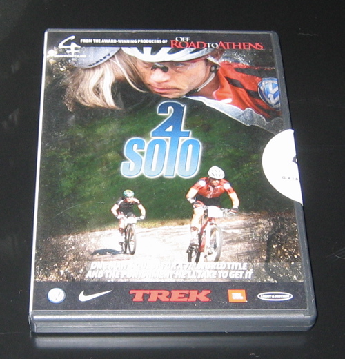
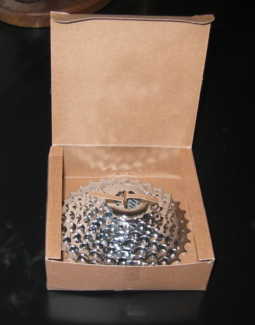
Looks like we finally had a winner for our daily contest ending today at 12pm EST. timd submitted two mountain bike gear reviews so he'll take home the DVD and skewer package…
We've been recommending the Garmin Edge series GPS for mountain bikers for about 6 months now and we're still loving it. The Edge gets great reception on the trail, it has a…
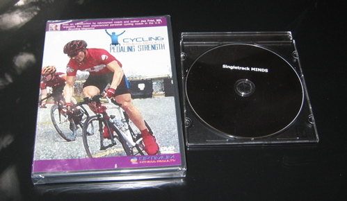
Today's prize package consists of two DVDs: Pedaling Strength from Cycling Fitness Results (brand new, in package) AND the Singletrack MINDS documentary from Poison Oak Productions. Post your trail photos in the…
Interbike was rad last week but I'm glad to be back in the ATL. No more live show updates obviously but I still have some pics and stories I plan on posting…
One of the other mountain bike websites is showcasing the "babes of Interbike" but how about this: The BIKES of Interbike. Here they are in no particular order, free bike pr0n for…
Allen Sports announced a new GPS-cellphone navigation system at Interbike this week that's a bit perplexing. I mean, the premise is that The Navigator lets you use your cell phone to navigate…
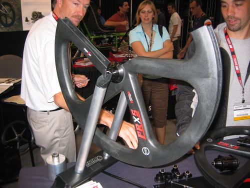
I talked with a rep from Tag Wheels about their new composite wheel system. The wheels are unbreakable (so far) and they seem like a good choice for downhill riders, jumpers, and…
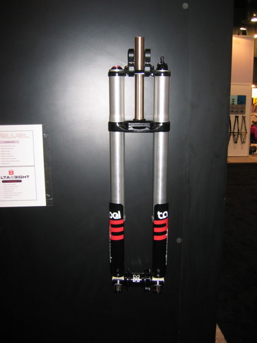
I poked around at a few booths looking for the biggest and baddest mountain bike suspensions I could find - and here's my report. Fusion The Delta Eight front fork has (you…
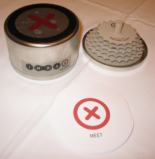
This morning I attended the announcement presentation for the new IMBA Ride Centers initiative and I gotta say I'm pretty stoked. The idea is that Ride Centers will show off best practices…
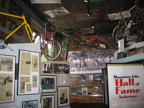
I got the chance to attend the 2007 Mountain Bike Hall of Fame Induction Ceremony at Interbike last night and it was pretty sweet (and not just because of the free Singletrack…
The Bomb-man requested some dope on the Magura Wotan and I was able to snap a few pics and pick up a few stickers. These things are true works of art, though…
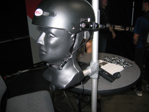
If you're looking for a pro-sumer level mountain bike helmet cam you might want to check out the V.I.O. POV.1. It's an integrated video capture system capable of recording 720x480 resolution at…


 3
3