Rust. Dirt. Grease. Grime. Mud. All of this adds up to a dirty drivetrain which can seriously harsh your ride. Fortunately Tri-Flow offers a full line of products to help you get…
National Public Lands Day @ Continental Divide Trail. Photo by Erika Knoth. Mark your calendar - this fall there are several official events you can participate in to celebrate mountain biking! As…
Believe it or not, this article can save you from visiting the dentist. Nope, this isn't about brushing your teeth (though a toothbrush is involved) - it's about servicing your mountain bike…
The first ever Pisgah Mountain Bike Stage Race is happening next month and from what we've read this could be a very cool race. Riders will compete over 4 days, riding 145…
The next tire in the WTB series that I'll be testing is the ground-ripping Stout 2.3. This tire is meant for nasty, gnarly terrain! With its wide offset spacing center tread pattern…
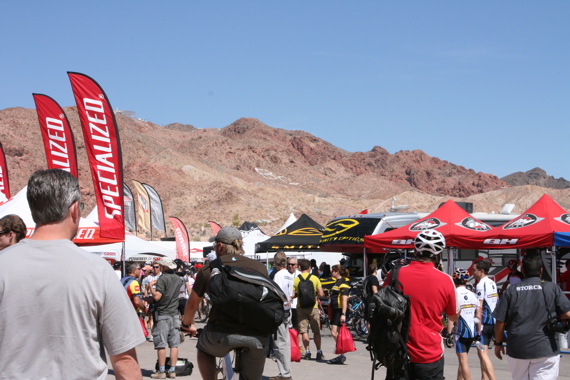
In less than 10 days element22 and trek7k are hitting the Las Vegas strip for Interbike 2009 and we're bringing everyone along for the ride! Well, not literally, but we will be…
ITS - or as most people know them, Intense Tire System - recently debuted new tire updates for 2010. The 2010 Edge EXDX comes in two flavors once again - a 1-ply…
IMBA's annual "Take a Kid Mountain Biking Day" (TAKMBD) is set for October 3, 2009 and if you register your event with IMBA before September 15 they'll send you a goody box…
For those who have purchased or are thinking about purchasing a singletracks premium subscription, just wanted to let you know about some recent improvements. High resolution trail maps in PDF We're rolling…
Not only does Manitou make a decent MTB fork, but you have to check out Manitou's line-up of ISX dampers. I was lucky enough to get my hands on an ISX-6 and…
29er mountain bikes are more popular than ever these days but there still aren't a lot of choices when it comes to components, especially wheels. Fortunately Easton offers 29-inch versions of two…
This is part II of an article on prepping for a 24 hour mountain bike race (here's part I in case you missed it). Whether you're part of a team or riding…
Just a few months ago yours truly was invited to compete in the Summer Solstice 24 Hour up here in ON. Fun times for sure, provided you're physically prepared and have all…
If you're in the hunt for a great All Mountain bike tire at a decent price, look no further than the Prowler MX from WTB ($50 MSRP). Aggressive, talon-like knobs will help…
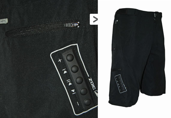
Depending on your perspective, this is either the coolest or most ridiculous pair of mountain bike shorts you'll ever see. The Opulent mountain bike shorts from ZOIC have iPod controls built right…
Don't let the name fool you: the Blue Ryno Carbon mountain bike isn't heavy or clumsy on the trail. In fact, like an actual rhino, this bike is fast, tough, and enjoys…
Photo from FirstFlightBikes / Museum of MTB Art & Tech Just in case you missed out on the government's cash for clunkers deal, a couple bike shops in Oregon and North Dakota…
You know what they say: VOIDH (video or it didn't happen). According to that logic most of us have never actually ridden a mountain bike but that can change with the VholdR…
I bet you if you ask any mountain biker what WTB is known for, the first thing they will mention is saddles - and there's a pretty good chance they own one…
A few mountain bike items to take a look at today: Mountain biking 101: How to get women into the sport. Diane Ursu posted a good article over on Examiner.com with tips…
Just a while back I reviewed the Easton XC-Ones and gave them a great review. But that got me thinking: I wonder what their all-mountain / light free ride wheels can do?…
Over the past few weeks we've been working hard to improve the trail mapping tools here on singletracks and I wanted to talk about some of the progress we've made so far.…
Specialized is going to hook up "a handful" of lucky riders this year with free access to 2010 Stumpjumper FSR bikes and sponsored MTB trips to hot trail locations. All you gotta…
"One ring to control them all..." Well three rings to control them all actually. Chris Wickliffe, the man behind WickWerks, was kind enough to send me a set of chainrings (MSRP $139.50)…
Lance Armstrong got his revenge at the Leadville Trail 100 today and set a new course record for the mountain bike race, finishing in a time of 6:28:50 (almost 20 minutes faster…
If you're not heading up to Buffalo Creek for the IMBA trail work party tomorrow you definitely need to get to Leadville for the big race. I'm pretty pumped after reading CogandChain.com's…
So we're heading to Interbike next month where we plan on recognizing the best mountain bike products of 2009 while previewing the new 2010 stuff. Based on your reviews we've put together…
Syncros is partnering with the International Mountain Biking Association (IMBA) to give IMBA members 25% off bars, headsets, wheels, saddles, seatposts, pedals, and tires. IMBA trailbuilders get an even better deal -…
A little while back I wrote a review on Mavic's Crossline wheel set which was and still is a great set of wheels. But I recently got a chance to ride with…
photo: 10K trail running race on the 1996 Olympic MTB course, sponsored by Dirty Spokes A lot of people ask me why I run so much - usually 3-4 days a week…
Buffalo Creek is probably my favorite mountain bike trail system in the world and the IMBA Trail Crew will be hitting the trails this weekend, August 13-16, to work and ride. The…
So this is pretty exciting: someone on singletracks is going to win a Contour HD Helmet Camera from VholdR at the end of the month. Take a moment to wipe the drool…
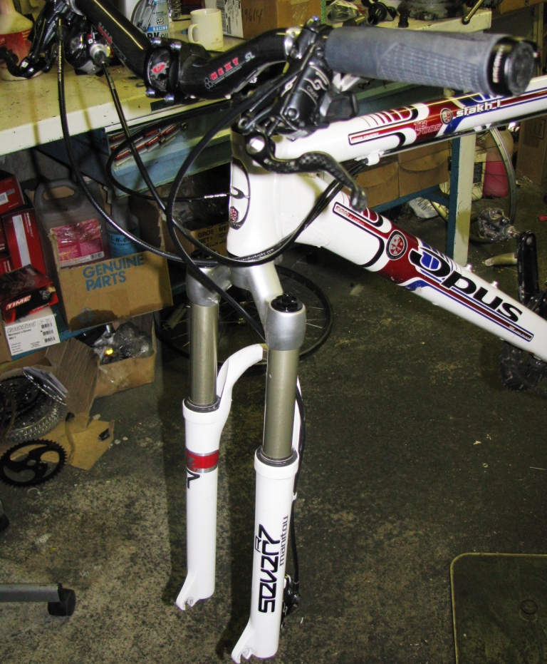
Whether you know it or not, you've probably experienced a mountain bike cable nightmare. Two weeks ago we asked you to share your stories of cable frustration and we got some pretty…
A little while back a few people were looking for bash guard recommendations in the forums and today I have a great product to tell you about. The e*13 Turbocharger ($49.95 MSRP)…
We've had a pretty good response so far but today is the last day to post your MTB cable nightmare for a chance to win a sweet set of Gore Sealed Low…
Schwalbe Wicked Will mountain bike tire review.
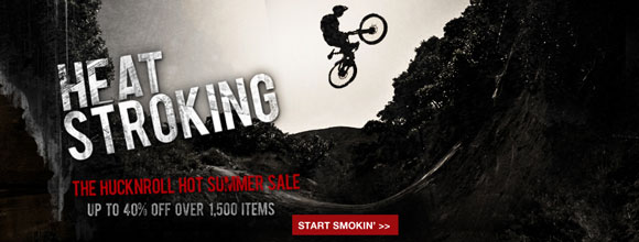
Just a quick shout: Big sale is on at HuckNRoll.com this weekend. If you received a $10 off coupon from singletracks this month, don't forget to use it through August 1 for…
Regular readers know I bought a new mountain bike earlier this year and while I've been sharing bits and pieces about my new ride it's time I wrote a summary review. The…
You may have seen mobile bike repair services advertised but apparently this is a new concept: a bike-powered bike repair service. Leave it to the Germans to find a way to use…
So yesterday I didn't get a chance to post on the blog and it was the first time in months, if not years, that we missed a weekday post. I left the…
Post your mountain bike cable nightmares on the forums this week for a chance to win a set of bomb-proof Gore RideOn Derailleur Cables. If you're not familiar with Gore cables, these…
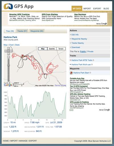
OK, now I get to show off a bit and for once I don't need to wear a helmet or ride along with constant fear of knocking out a tooth. Just look…
I've always been proud to show off my wounds and scars from mountain bike crashes, but there is actually a much easier way to show off my love for the sport. Bike…
Heil Valley Ranch map courtesy Boulder County. (you are not actually "here" :) ) We've said it before and we'll say it again: singletracks.com exists to help you find the best mountain…
Last month I wrote about a somewhat disappointing MTB trail recon trip to middle Georgia and I actually got a lot of sympathy (though that wasn't my intent at all). The fact…
Faster than a speeding bullet, able to leap over rocks and tree branches, and more powerful than your two legs can handle! Kenda's stable of tires are famous for superhero-like performance and…
About a year and a half ago I wrote about mountain bikers' carbon footprints (er, carbon tracks) and a press release from Performance Bike got me thinking about Green MTB once again.…
Daniel Hume, RIP. Photo from telegraph.co.uk. Some sad news to report this week: Daniel Hume, former pro mountain biker from the UK, was killed while on foot patrol in Afghanistan last week.…

 4
4