Lance Armstrong dropped out of the Miles of DisComfort Marathon in Texas with leg cramps, raising questions about his readiness for the Leadville 100.
# Option 1 (24 words):
The West Virginia Wilderness Bill threatens to eliminate mountain bike access to over 50 miles of trail in Monongahela National Forest including Dolly Sods North.
# Option 2 (23 words):
New wilderness designation could close over 50 miles of mountain biking trails in West Virginia's Monongahela National Forest; WVMBA urges riders to contact representatives.
Trade your skis for knobbies this weekend at Maine's Shawnee Peak, where over 100 racers will tackle snow-covered slopes on mountain bikes for just $30.
Mountain Hardwear designer Sean McDevitt describes 24-hour solo racing as "horrific," saying riders "come face-to-face with your soul" during the grueling endurance events.
A young Czech artist designed a French beret-shaped bike helmet with LED lights, but sadly there are no plans for commercial production.
# Suggested Excerpt
"Winter riding woes continue as only 27 brave souls endured a miserable rainy endurance race in freezing temperatures down South."
---
**Word count:** 22 words
**Style notes:** This captures Singletracks' conversational, relatable tone while highlighting the key story (the poorly-attended race in brutal conditions) that exemplifies the winter riding struggles mentioned throughout the article.
# Suggested Excerpt
**"After skipping a SORBA ride due to snow fears, this Georgia rider feels humbled reading about epic winter rides in Alaska's brutal conditions."**
*Word count: 24 words*
This excerpt captures the self-deprecating tone while highlighting the contrast between the author's weather worries and extreme cold-weather riding, typical of Singletracks' conversational style.
**Skip the slopes this MLK weekend and give back to your local trails by volunteering or doing a rolling clean-up ride instead.**
Mountain bike company stocks have mostly crashed and burned, but investing in an actual bike might offer the best returns—in adrenaline, at least.
USA Cycling taps five-time UCI racer Mike "Gully" Gullickson to lead mountain bike and cyclo-cross programs just months before the Olympics.
SORBA hosts a winter MTB festival in Macon, Georgia this weekend featuring Thomson factory tours, endurance racing, camping, and group trail rides.
Welsh town hosts chariot race using mountain bikes to pull chariots in a Saturnalia festival celebrating Roman drinking, food, and fun with togas required.
High-end mountain bikes often cost more than dirt bikes, possibly due to import differences and the premium placed on US and European manufacturing in the MTB world.
From action cams and touchscreen GPS units to electric bikes, here are a few mountain bike-worthy gadgets on display at CES in Vegas.
A mountain biker has been pedaling across Asia since last April, starting his epic journey near Mount Everest's base camp.
Mountain bikers can reduce their carbon footprint by carpooling to trailheads, purchasing carbon offsets, and advocating for more local trails near home.
Mountain bike legends gather in Marin County for Trips for Kids' annual fundraiser featuring raffles, brews, and a Jamis Dragon Comp grand prize.
Looking to stick to your 2008 mountain bike resolutions? Commit to riding an epic event this year, from century races to challenging backcountry adventures.
President Bush receives "vacuum-sealed" Shimano mountain bike shoes from Japan, while California mandates lights for sidewalk cycling but not trail riding.
Find mountain bike trails and compare gear prices on the go using your mobile phone's browser with Singletracks and BikeSomeWhere's mobile sites.
A New Year's Day revival ride at Georgia's redesigned Stonewall Falls Loop delivered 7.5 miles of pristine singletrack and multiple freezing stream crossings.
Christini's long-travel AWD mountain bike uses innovative all-wheel-drive technology to conquer slick climbs and winter conditions that would challenge traditional bikes.
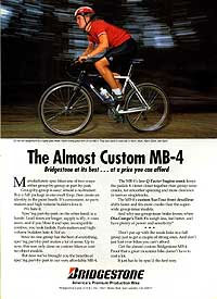
Looking back at iconic 1990s mountain bike brands like Bridgestone and Fuji, and wondering which defunct companies deserve a comeback.
Blue Mountain Ski Resort hosts annual Bikercross race where riders equipped with screw-studded tires bomb down a sculpted black-diamond slope at 50+ mph.
# Suggested Excerpt
**Mountain bike wheel sizes are evolving beyond 26-inch, with 29ers, 650b, and mixed combos offering different advantages for terrain, rider fit, and performance.**
(24 words)
From 650b wheels overtaking 29ers to GPS going mainstream, here are six bold predictions for what mountain biking will look like in 2008.
The Singletracks blog launched in January 2007 and published over 300 posts, with GPS guides and quirky stories proving most popular with readers.
The inaugural Baja Epic mountain bike race takes riders through remote Mexican terrain November 5-8, with early registration discounts available through May 30.
Cervellum's prototype rear-view camera and handlebar display offers roadies a high-tech alternative to mirrors, though handlebar clutter remains a concern.
Mountain biking beats gym memberships with fun, low-impact, full-body workouts that keep you coming back for more adrenaline-pumping trail sessions.
Major bike manufacturers like Haro and Fuji are adopting 650b/27.5" wheels, with tire makers and wheel builders following suit in this rapidly growing trend.
"Our server literally caught fire this week, but we're back online with new hardware and all your data intact."
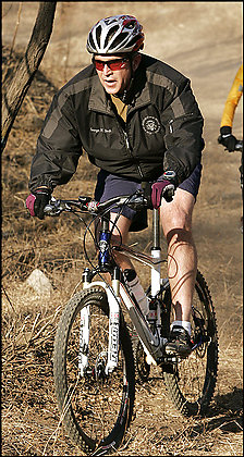
President Bush rides singletrack Saturday mornings at a Secret Service facility in Maryland, and he's reportedly obsessed with biking metrics and data.
Marilyn Price, founder of Trips for Kids, needs your votes to win the Volvo for Life Awards and a $100,000 charitable contribution.
Liberty University plans to build downhill and cross-country mountain bike trails on campus to attract students with "good clean fun."
BLM opens Free Lunch, its first purpose-built downhill trail in Fruita, featuring 7-foot drops, wall rides, and gap jumps for expert freeriders.
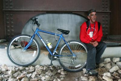
Austin bike shop owner and IMBA board president Hill Abell donates a new mountain bike and accessories to a 63-year-old homeless man for Christmas.
Gary Fisher discusses mountain biking's "second coming," covering advances in bike technology, trail building improvements, and the internet's role in the sport's growth.
Internal geared hubs are finally making the leap to mountain bikes, offering weather-proof shifting and low maintenance in lightweight packages that rival traditional derailleurs.
California wildfires forced Ellsworth to evacuate and closed area bike shops, while Limestone Canyon and Whiting Ranch trails suffered 90 percent burn damage.
Here's a one-sentence excerpt in Singletracks.com style:
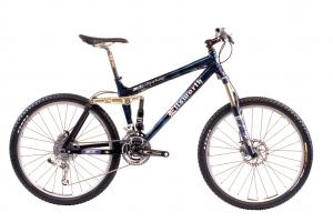
3Luxe picks the Ellsworth Epiphany, Sycip Diesel, and K2 Apache as the world's best mountain bikes—questionable choices that leave us scratching our heads.
Two industrial design students created this gnarly mountain bike/motorcycle hybrid featuring MTB components paired with a gas engine strapped to the frame.
The revolutionary Delta 7 Arantix pushes carbon-fiber technology to new extremes with its radical lattice design, raising questions about durability and innovation.
Magellan's new Triton 2000 GPS packs a touchscreen, LED flashlight, MP3 player, 2-megapixel camera, and voice recorder into one slick outdoor unit.
Google Maps adds terrain view with topography and park boundaries, making it a much better tool for mountain bikers to scout trails and elevation.
From GPS units and Fox suspension to Santa Cruz full-suspension rigs, Singletracks members aren't shy about dreaming big this holiday season.
The Guardian profiles Raleigh's business transformation, revealing the 100+ year-old British company also owns Diamondback while struggling for profitability and market share.
Hunters are trading ATVs for mountain bikes to access wilderness quietly, efficiently transport game, and avoid scaring away prey while saving gas.

 1
1