The lightweight Giro Athlon mountain bike helmet delivers exceptional ventilation, a secure fit, and barely-noticeable comfort for riders who demand performance without compromise.
Metro Atlanta's Board n Bike collects used bicycles for single mothers through December 15, while national charities like Trips for Kids welcome year-round donations.
Gore's Windstopper Tool jacket and Fusion SO pants offer wind and water resistance with thoughtful features for extending your riding season into colder months.
Canada's first indoor bike park offers 90,000 square feet of pump tracks, progressive jumps, foam pit, and elevated XC loop opening December 14th.
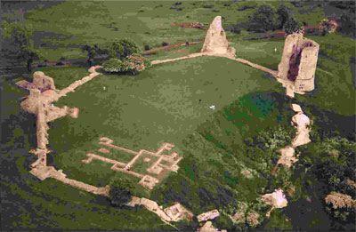
The 2012 Olympic mountain bike course at Hadleigh Castle will remain open to the public after the games conclude in London.
The WTB Vulpine 29er semi-slick tire excels on fast hardpack trails with its lightweight design, though cornering grip suffers in loose conditions.
Straitline Components started in a garage with a retirement bonus and grew through NASA contracts before applying precision aerospace machining to mountain bike parts.
Answer returns with Fall Line DH grips and Rove FR pedals designed for downhill and freeride contact points that matter most.
This face-forward mountain trike concept lets riders pump both legs simultaneously while lying prone just inches from the trail like a prowling cheetah.
Learn to identify and utilize natural features like ridgelines, benches, and rock gardens when scouting terrain for your next mountain bike trail build.
A 2006 study found Viagra improved cycling performance by up to 45% at extreme altitudes above 12,700 feet, though it showed no benefit at sea level.
Formula RX brakes offer excellent modulation and solid stopping power for XC to light freeride riders at a more affordable price point.
Jason Priestley options Rolling Stone's story about freerider Sam Brown's double life as drug smuggler for potential mountain biking movie.
Gore tests waterproof gear in extreme conditions using climate chambers, rain rooms, and continuous wash cycles before approving designs for production.
Hayes introduces three affordable maintenance tools for mountain bike brakes: the Pro Bleed kit, Stroker tool kit, and Feel 'r Gage pad spacer.
Mountain bikers can stay safe during hunting season by wearing orange, riding mid-day, making noise, and checking for trail closures with land managers.
A basic guide to getting started with trail building.
Here's a one-sentence excerpt in the Singletracks.com style:
"Race Across the Sky, documenting Lance Armstrong's showdown with Dave Wiens at Leadville 100, returns to theaters November 12."
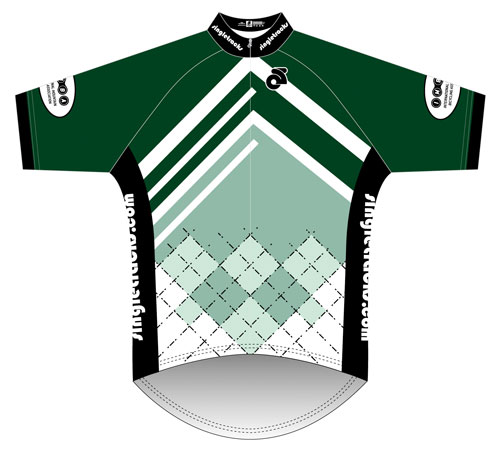
Singletracks launches custom jersey pre-orders with proceeds benefiting IMBA; first ten buyers receive free Pro membership with their $55 purchase.
Meet Bob_the_Builder, a dedicated trail builder transforming Ontario's singletrack into magazine-quality rides, now sharing his expertise on Singletracks.
Rebecca Rusch discusses her transition from adventure racing to mountain biking, her dominant Leadville 100 victory, and why listening to your body beats technology.
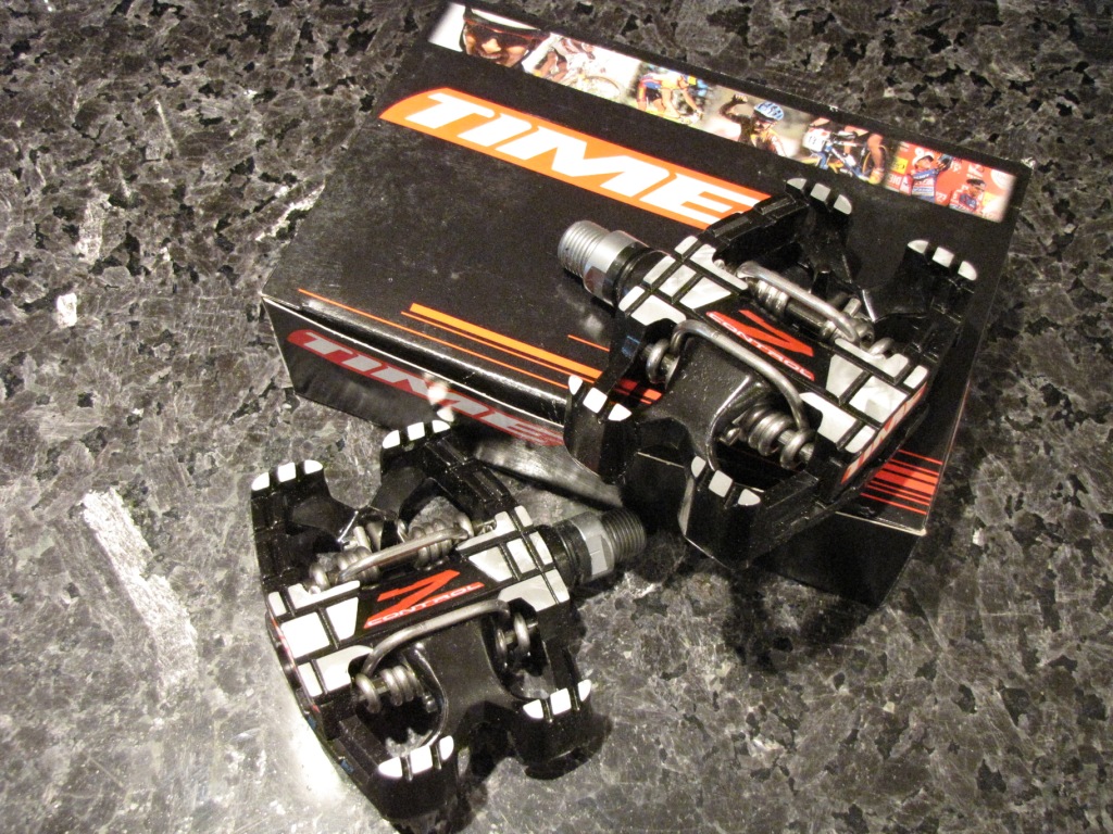
A review of the Time Z-Control clipless mountain bike pedals.
Here's a one-sentence excerpt in Singletracks style:
We visited Gore-Tex headquarters to learn how their waterproof, breathable membrane is made and why it actually works for mountain biking.
The Xterra Triathlon World Championships in Maui featured 550 athletes competing in a 1-mile swim, 20-mile mountain bike, and 7.5-mile trail run.
Here's a suggested one-sentence excerpt in Singletracks style:
**Enter to win a bike ride with Lance Armstrong in Austin by becoming a Clear2Go fan on Facebook through December 2.**
(20 words)
IMBA urges mountain bikers to comment on North Carolina's State Parks plan by October 31, supporting expanded singletrack trail access and development.
The Maxxis Minion 2.35" tires deliver exceptional grip and control for all-mountain riders who need aggressive traction without the bulk of full DH rubber.
Race Across the Sky delivers an inspirational look at the Leadville 100, showcasing Armstrong's dominance, Wiens' class, and the incredible drama of high-altitude racing.
The 2010 Opus Nelson 1 is a purpose-built freeride machine with 7 inches of travel that excels at high-speed descents and soaking up drops.
The Leadville 100 mountain bike race documentary featuring Dave Wiens and Lance Armstrong hits theaters nationwide for one night only.
Atlanta's Down South Cyclery brings Barnett-trained bike repair to your door with affordable prices, same-day service, and no separation anxiety from your beloved bike.
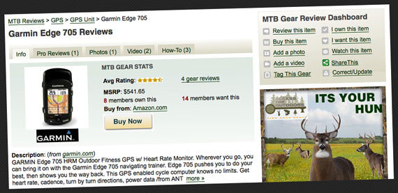
Singletracks rolls out updated MTB gear review pages with new tabs for pro reviews, photos, videos, and how-to guides alongside member ratings.
A photo tour of Interbike's hottest mountain bikes and components, featuring drool-worthy DH rigs from Intense, Banshee, and Ellsworth plus cutting-edge suspension tech.
Nuun Active Hydration tablets add electrolytes and flavor to your water without the sugar crash, and they won't gunk up your hydration pack.
IMBA adds five new Epic trails from Georgia to Washington, featuring technical challenges, stunning scenery, and world-class mountain biking adventures.
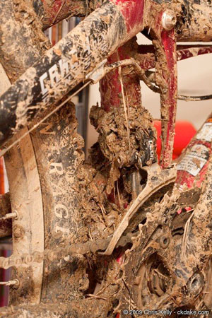
We asked readers to submit photos of their filthiest drivetrains, and the winner's grime-caked crank showed serious neglect and impressive wear.
The Light & Motion Seca 900 Ultra pumps out a retina-searing 900 lumens, turning pitch-black trails into a daylight bubble for night riders.
A review of the Maxxis Ardent mountain bike tire.
Lance Armstrong signs 3-year deal with Michelob Ultra, trading energy drink ads for beer commercials as spokesman for the low-calorie brew.
Mountain biking categories span from XC to downhill, with most bikes and riders covering a range rather than fitting neatly into single classifications.
A dedicated mountain bike coaching trail in the UK features berms, tabletops, rhythm sections, and technical climbs exclusively for skills instruction without interruption from other riders.
Mountain bike news roundup: backyard bikepark projects, Rio's 2016 Olympic trail plans, Chicago's venue challenges, and VHoldR's new full HD helmet camera.
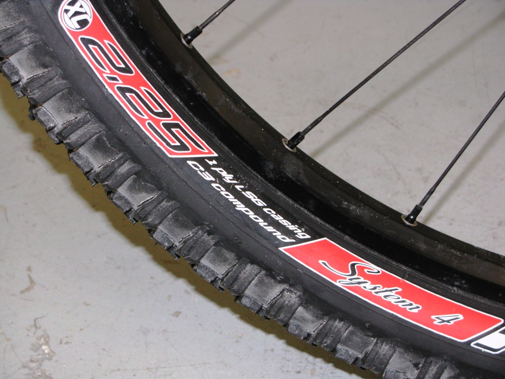
Intense Tire Systems' System 4 and 5 XC tires offer versatile fall performance with high volume casings that resist pinch flats for heavier riders.
Six-time 24 Hour Solo champion Chris Eatough retires, Trek lobbies for Chicago Olympics, and riders tackle a grueling Himalayan stage race.
Giro's Xen helmet and gloves combine with Filter sunglasses to create a complete all-mountain protection package that handles rough trails with style and comfort.
Easton debuts fresh 2010 graphics across their component line, plus the striking Haven all-mountain wheelset—their first UST offering with straight-pull spokes.
The Tri-Flow Dirtiest Drivetrain contest ends October 1st—submit your grimy, rusty, gunked-up bike pics for prizes and glory.
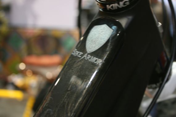
Bike Armor offers custom-cut, clear protective film decals that shield your frame from scratches and dings without hiding your bike's graphics.

 1
1