
Having ridden most of North America’s great mountain biking destinations, I find it hard to answer when someone asks me which is my favorite. Each destination is unique, having its own charm and appeal, leading to an apples-to-oranges type of reaction on my part. How can you compare the endless downhills of Downieville to the joyous miles of high desert singletrack of Fruita? Or the Slickrock of Moab to the high altitude magnificence of Breckenridge or Bozeman? Yet if you asked me, on any given day, if I could be teleported to any location for the coming week, free of charge and with no time penalty, more often than not, my answer would be none of the above, but rather Sedona, Arizona.
We included a paragraph on Sedona in our recent article, “The Top 10 Mountain Bike Destinations in North America.” In this article, I made a rather audacious claim, that Sedona has singletrack like Fruita, slickrock like Moab, and scenery that beats them both. If that is an exaggeration, it isn’t by much, and I stand by that statement to this day–especially the scenery part. Sedona is positively other-worldly.

But Sedona can be a very tricky place for the uninitiated. On one hand, you can wander into town with but a couple hours to ride and, whatever trail you chose, you’d have an excellent time. However, if you want to maximize your Sedona riding experience, whether just passing through in one day, or staying for a week, a little orientation is in order.
Sedona is literally surrounded by singletrack, most of which can be joined in one way or another, although occasional outlying city streets and encroaching Wilderness boundaries will interfere if you’re not prepared. To add to the confusion, Sedona has been a hotbed of bandit trail construction and often negative response from the USFS. Locals’ trails are everywhere, and it’s hard to know if you’re staying on your intended route, or even a legal route. The good news is that the USFS has actually brought some of these previously illegitimate trails into the official fold. The bad news is that some trails which have been ridden for years have been officially designated as verboten, and even obliterated.
In this installment, I’ll introduce those trails which lie on Sedona’s east side. These are the most varied trails in terms of range of riding abilities and, despite their relative ease of access, provide jaw-dropping scenery around every bend.
Be advised that most of the trailheads in the “Red Rock Country” require a parking permit, which costs $5/day or $15/week. These funds are crucial to maintaining these high traffic areas and shouldn’t dissuade anyone from checking the area out.

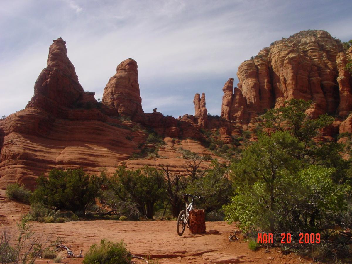
Central Sedona and the Village of Oak Creek are separated by six miles of Highway 179, one of the most scenic stretches of highway you could ever hope to drive; between the highway and the Munds Mountain Wilderness lie a couple dozen miles of singletrack and scenery to die for.
This network is anchored by the very wide, popular, and novice-friendly Bell Rock Pathway, a dirt and slickrock route which gives even the first timer access to some of the area’s best vistas, including the pathway’s namesake, Bell Rock, and the awesome Courthouse Butte. At the south end of the pathway, lying between Courthouse Butte and the Village, is the still novice-friendly, but genuinely narrow and entertaining, Big Park Loop. This trail can be a real hoot, even for non-newbs, especially when ridden clockwise.
The Village of Oak Creek makes an excellent base for your Sedona explorations. There are a dozen hotels within riding distance (which tend to be less expensive than those in Sedona Proper) of the trailhead (as well as the west side trails I’ll cover in the next installment). It also has two three quality bike shops within a couple blocks of the trailhead: Absolute Bikes, the Sedona Bike and Bean, and Over the Edge Sports. Dining options are a little scarce here, so a drive (or ride) into Sedona proper may be on the menu.

While the scenery on the Bell Rock Pathway is beyond exceptional, what’s under your knobbies isn’t. Intermediate and advanced riders will want to make their way over to the Llama Trail, which runs parallel to the Bell Rock Pathway and rides well in either direction. A simple loop can be had by taking the Bell Rock Pathway north for 3 miles to the Little Horse Trail and hooking northwest 0.6 miles to the Llama intersection, which will bring you back to the Bell Rock Pathway after 3 miles of sweet singletrack.
The Little Horse Trail also rides another mile north to the magnificent Chicken Point. If going to Chicken Point, I prefer to access it via the Broken Arrow Trail, which starts at the end of Morgan Road on the south end of Sedona proper. While it’s only a couple miles, the Broken Arrow trail serves up plenty of challenge in the form of steep climbs, narrow singletrack, exposure, and plenty of piñon and cactus to duck, as well as some of Sedona’s more interesting geologic wonders.
The route takes you to the “Devil’s Dining Room,” a hundred-plus-foot-deep sinkhole dropping right out of the bedrock. There’s also an optional 0.6-mile out-and-back detour to Sedona’s famed Submarine Rock, aptly named due to its unusual shape.
On the west side of the Broken Arrow trail lie the challenging Hog Heaven and High on the Hog trails, plus a couple slightly less exposed routes known as Hog Wash and Pig Tail, plus the easy Mystic trail. At last check, the pig-themed trails were not formally adopted by the USFS, but had not been marked off limits, either. Be sure to check on their status before going hog wild here.

The other east side complex, which is cut off from the rest (for bikes) by Wilderness, includes some of Sedona’s most dramatic scenery… and spookiest exposure. The Munds Wagon Trail climbs a rough route up Bear Wallow Canyon parallel to Schnebly Hill Road to an intersection with the Cow Pies Trail, so named because of the “plop, plop, plop” appearance of the rocks at its high point. Fortunately, they are the same gorgeous red rock endemic to the area rather than… well, you know.
At its end, Cow Pies meets up with the Hangover Trail, which then loops back down to Munds Wagon. Here’s where things get interesting. No, the Hangover trail isn’t so named because the person who laid it out had a hangover, but rather because of the overhanging rock you’ll duck under as you hang over big exposure below. This trail is not for the faint of heart. This route also led to the Damifino trail; when the USFS got involved in this area, both Hangover and Damifino were unsanctioned. Hangover was brought into the fold, but Damifino was given the axe. While I generally hate any trail closure, I give the USFS big kudos for sanctioning the amazing Hangover trail and legitimizing its use for cycling.
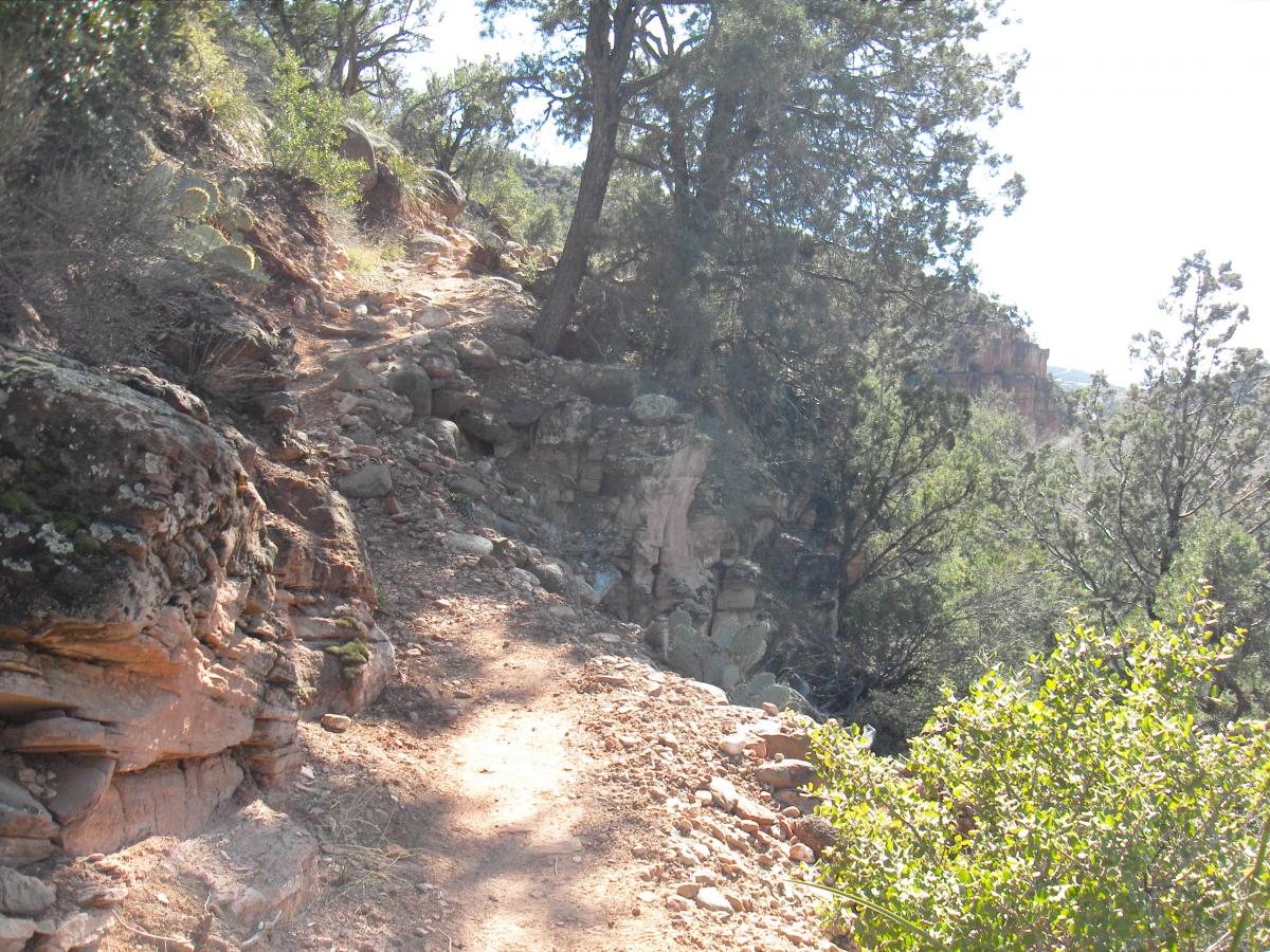
Lastly, on the east side is the Huckaby Trail, which runs from the Munds Wagon trailhead north to the base of Midgley Bridge on Highway 89A. While most people ride it this direction, I prefer it north to south–you’ll have an equally-challenging experience in either direction. This trail sees little use, and there’s good reason why: it’s positively brutal in either direction, and the only decent loop you can make with it requires a good deal of pavement through town, crossing or riding on the busy highway, and crossing Oak Creek, which can be treacherous, especially during spring runoff. Huckaby is one of those trails I’m very glad I did, but I’m in no hurry to do again.

For years, the best way to approach Sedona was with a local or frequent rider. However, thanks to USFS sanctioning and increased popularity, good maps are now available, trails and intersections are picking up good marking, and someone not so hooked up can still create an excellent experience of any duration.
Stay tuned…
In the next installment, we’ll cross to the west side of Highway 179 and hit more of Sedona’s magnificent routes.


2 Comments
Feb 8, 2014
Feb 3, 2014