

Cycling8r recently shared her backyard trails in the Sandia Foothills on the east side of the great mountain bike city of Albuquerque. One of the things that makes Albuquerque such a great place is the proximity of such trails. But the largest city in New Mexico has so much more to offer a little further beyond.
Traveling East from Albuquerque on I-40, one passes though a notch separating two great mountain ranges: to the north are the Sandias, and to the south are the Manzanitas. If you’re looking for a little more kick out of your ride than the Sandia foothills next to town, driving around to the backside of the Sandias will certainly deliver (as will the Manzanitas, the subject of a future article). For now, we’ll concentrate on the Sandias.

After passing through the town of Cedar Crest, a turn to the West on NM536 will deliver you to the base of the Sandia Peak Ski Area, home of the infamous King of the Mountain, which ascends the 1,800 vertical feet to the 10,600ft ski area summit over a distance of eight miles. While that doesn’t make for a huge average grade, this route will definitely keep your heart rate up for an extended period of time.
The trail itself isn’t particularly interesting: traverse a couple hundred yards, switchback, and repeat… many, many times. On a couple of occasions, the trail dips into some surprisingly deep, dark woods and hits some technical sections which, while challenging, provide some relief from the monotony of the repetitious climbing/switchbacks. Overall, this climb seems tougher than others I’ve done with a similar elevation profile.

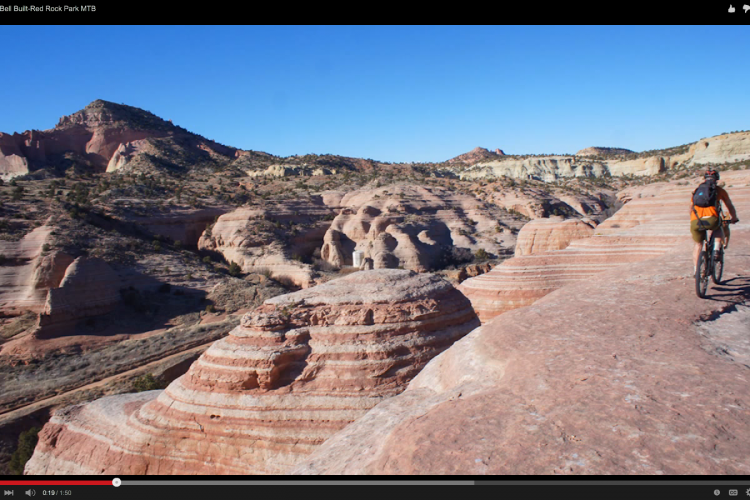
In addition to being able to catch your breath, there are two other benefits to reaching the summit. The first is the view. The unobstructed vista down upon the city of Albuquerque and along the ridge of the Sandia Crest is spectacular.
Coincidentally, the top of the climb coincides with the top of the Sandia Tram, which brings tourists up from the Albuquerque side, as well as skiers wishing to shred the Sandia Peak Ski Area in the winter. This convergence also hosts an upscale restaurant with an excellent observation deck. The food is good, but the prices are far higher than what you’ll pay for similar fare in town; you’re paying extra for the spectacular setting. There is also a road to the top which is used largely by folks who want the view without the work. As such, you’ll find the trails near the summit to be fairly congested with hikers during peak times.

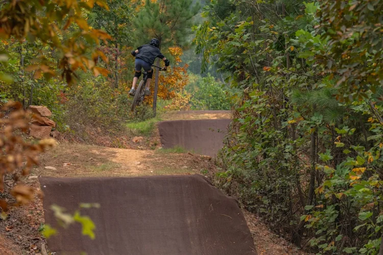
The second benefit to summiting is, of course, the fact that you now get to bomb back down the mountain! The King of the Mountain trail is two-way, so you can go back the way you came. However, the Golden Eagle Trail is downhill only. Making this unique is the fact that Golden Eagle is largely a beginner-friendly green circle trail`–rare for a ski area downhill trail. The grade is usually mild, most curves are bermed and none are off camber, and this trail is even smoother than the King of the Mountain climb. Of course, if you don’t want to earn your turns, you can come here on a summer weekend and let the chairlift overcome gravity for you. Just know that this isn’t the type of ski area to satisfy the full-face helmet, armor-wearing, dual crown fork crowd.

If you’re looking for a more organic riding experience, the tail system lower and closer to Cedar Crest, which is anchored by the Faulty Trail, is just the place for you. If you’ve read about this trail in the Falcon Guide, ignore it—the loop described is no longer available, the southern end having been closed by private property. However, this remains a robust network with numerous route options to keep you coming back, especially given the quality of the trail, the excellence of the scenery, and the lack of competition for trail solitude.

The Sandias are a fault block range (hence the name “Faulty Trail,” lest you think there’s anything wrong with the trail itself) composed primarily of granite with a layer of limestone on top. Consequently, you get a variety of riding conditions on the rough back side, from perfectly tacky loam to all forms of chunk, from small, lose sedimentary breakaways to big, square rollers and step ups. A good variety of trail riding skills will come in handy on a Faulty excursion.
The best launching point for a Faulty ride is the Doc Long trailhead. The ride starts out with a brief but challenging and entertaining climb up the Bill Creek Trail to a three-way intersection with the Oso Corredor and the Faulty Trails. The Faulty Trail heads south for about five miles before looping around a small lollipop and returning.

Heading back doesn’t automatically mean a pure out-and-back, as there are a number of trails which can create loops by dropping off toward the valley floor. The longest and best of these is the Armijo Trail. Other than a short section which is more a jagged, rock strewn wash than an actual trail, the rest is sweet singletack swooping through the hardy pine forest. If you take this route, there will be a little pavement riding and a couple tricky route finding spots if you want to take the most efficient path back to the Doc Long parking area. If lost or in doubt, simply swing back out to NM 536 and take a short spin back up the highway to where you started.

If you’re really looking for a big day with a lot of climbing, at that three way intersection, you can take the Oso Corredor trail up the mountain. It will eventually meet the Tree Spring Trail, which will in turn take you up to the 10K trail, so named because it fairly closely follows the 10,000ft elevation line, just below the Sandia Crest. The 10K Trail proceeds Northwest through the ski area and once more crosses NM 536. If you follow the 10K Trail to its Northern terminus, you can add a small loop by throwing in a tough, but short, 0.3 mile climb to the Ellis Trail, and return on it as far as the highway.

Straight line, the rides described here, and the North Foothills covered in the previous article are a few short miles apart, however it is not viable to connect them as any trails in between pass through the Sandia Mountain Wilderness Area and are off limits to bikes. In fact, the routes described above are hemmed in by Wilderness as well. A good map of the area will be very useful both in helping you find a route to your liking as well as keeping you out of trouble.
This is an awesome area to mountain bike, and but one of many around Albuquerque. It should make anyone with a requirement to visit the area glad they have received such a task/benefit!

Stay tuned for Albuquerque, Part 3!


1 Comments
Mar 13, 2014