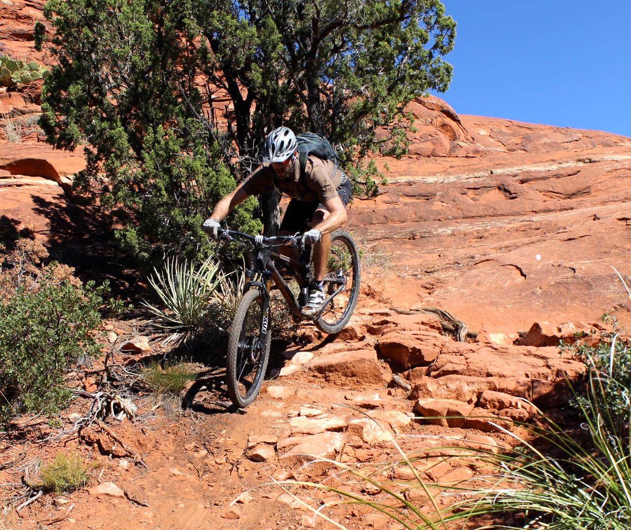
Hiline Trail is an expert-level mountain bike trail that is best ridden from the Village of Oak Creek side -- finishing on the Baldwin Trail loop. There is some exposure along the narrow, ledgy trails during the climb up. The descent on the far side has some steep, loose areas that most bikers will choose to hike.


 2
2

First of all, the trail map on this page is NOT the Hiline, it's Slim Shady, Templeton, and Baldwin's Loop.
This trail has what is probably the longest high-speed descent in Sedona, which is what makes it so fun.
The exposure on the east side of this trail is pretty epic, don't be a hero. There are spots where if you hit your bar end on a rock, you can be pitched down a loooong way. The chute on the back end of this trail is an attention getter, know your limits or you will pay ( I speak from experience lol ).
The views are some of the best in Sedona, especially of Cathedral Rock. When you hit the Baldwin Loop hang a right and hit the Templeton and take that to Slim Shady to Made in the Shade back to the Village. That's a damn fine loop right there!
| ThankGreat ride if you know your limits and don't try to be a hero! Plenty to enjoy even with some hike a bike.
| ThankSuper technical climbing and descents. Great views the whole way. Definitely a true double black diamond trail. Know your limits
| ThankPurposefully didn't give this a star rating, because it depends greatly on your skill level. The views are awesome. There is quite a bit of tech, but I wouldn't call most of it double black diamond (there is one crazy drop section near the back). What makes it double black is the exposure - there are several sections where if you screw up, you could be in serious trouble. If you're Intermediate and not from the area, there are plenty of other trails in the area that you'll have more fun. If you're expert with no fear, hit it.
| ThankA great singletrack experience. Plenty of exposure but the views are amazing. A slickrock section leads to a highly technical downhill stretch that seems a bit out of sync with the rest of the trail.
| ThankLevel 3 type fun. Very challenging trail, but doable if you're on your game. I would call it The Hangover's little brother. A great mix of tech climb, exposure, and flowing fun.
| ThankThis was my first time in Sedona and the views and rock formations were amazing--well worth the drive up from Phoenix. Exposure not really an issue. The slick rock descent put a big smile on my face and was the highlight of the ride (next to the views).
The double black diamond portions were very, very steep--they make a lot of other diamond runs look green. I only rode about half and walked the other half but it pushed my limits and made me a better rider.
I connected to Hiline from Slim Shady, which I connected to by riding a block from Absolute Bikes. I know this is a rating for Hiline but it is not an out-and-back or loop, it's a one-way so you have to ride other trails to get back to Slim Shady, and those other trails were not great and that affects the experience of Hiline, which is why I rate it a 4.
| ThankFollowing a moderate climb this trail hosts quintessential Sedona views. Following the climb an easy and fast descent delivers you to a very technical slickrock descent.
| ThankHi-Line, above my ability but a great time! Highly suggest you ride the first time with someone that knows the trail! Many areas I walked or had to attempt more than once, but well worth the effort!
| ThankThis trail is not super technical except for one short section of the descent. There is a lot of intermediate/advanced climbing. Then there is a rowdy descent mostly on rock, that I'd call advanced. Then there is a short double-black section that is made up of 4-5 very steep spots. An intermediate rider shouldn't be afraid of doing this trail, just expect to maybe walk some short sections.
Seemed like a lot of climbing without much payoff, but I was having a rough day. Need to do it again for a fair judgement.
| ThankThis is one of the best trails I've ever ridden for pure enjoyment factor. The ledgy ride up is smooth with the 'risk' being the exposure (which if you're not afraid of heights, is not too intimidating). I am so happy I rode this trail, the views are second to none and the downhill is challenging and fun!
| ThankAs an intermediate rider with a hardtail and 26" tires and this trail is still epic and worth doing. Unlike some of Sedona's double black diamonds, 95% of the insane parts are in one continuous section so most of the trail has an amazing flow if you are used to Sedona type trails. The technical downhill section is even tough to walk your bike down but it's all well worth it.
| ThankHiline is a true gem of a trail, with fantastic serpentine singletrack along the ridge with astounding views, to a gnarly, super-challenging descent down the mountain. This is a must-ride!!
| Thanknot to be a doucher, but it's technically 'HILINE' Trail...
| ThankIf you want the badest Sedona has to offer, just try and hit every trail that starts with an 'H'... You will not leave disappointed..
Started off on Slim Shady by the Bike and Bean bike shop which was a nice trail. The initial climb on Hi-line was great with some fun technical rock. The traverse along the exposed bench to the top was great as was the initial flowy descent. Just as I was saying to myself this trail rules you get to the ridiculously technical descent that kills all of your elevation. Kind of reminded me of the Portal Trail in Moab. Once we walked a couple of sections it was easy not to even try the others. I'm sure a lot of ballsier riders would love it and it wouldn't have bothered me if it didn't just kill of the elevation this trail had left. Felt more like a "how do we get off of this thing" than an intentional tech part. The ride back on Baldwin was ok. Templeton was annoying as there were a bunch of hikers. Not really a mtb trail. Scenery was a 10 but the epicness of the trail didn't last long enough for me to give this one a 5.
| ThankStarted off on Slim Shady by the Bike and Bean bike shop which was a nice trail. The initial climb on Hi-line was great with some fun technical rock. The traverse along the bench to the top was great as was the initial flowy descent. Just as I was saying to myself this trail rules you get to the ridiculously technical, all-in and clean it or get jacked up, lose all of your elevation in a not fun way descent. Kind of reminded me of the Portal Trail. I'm sure some people can ride it of course but not me and I think I'm a pretty decent technical rock rider. Once we walked a couple of sections it was easy not to even try the others. The ride back on Baldwin was ok. Templeton was annoying as there were a bunch of hikers. Not really a mtb trail. Scenery was a 10 but the epicness of the trail didn't last long enough for me to call this one a classic.
| ThankAwesome trail, definitely not for the faint of heart. It's got a lot of technical decents that make the journey up worth it all. Crazy fun
| ThankSo much fun, big climb at first but once you reach the top it's a blast all the way down with sweet drops, rock gardens, and super technical decents. Crazy fun trail
| ThankI road this yesterday. I am not sure what the Buddha Beach loop is. I linked Slim Shady to Highline to the Baldwin Loop to Tempelton and back to Bell Rock via Made in the Shade. Maybe the most awesome ride I've done.
Highline is a grunt up to the top. Then some super fun single track. There are a number of steep roles and drops that I had to walk. I am not sure if I would have had the ball to ride the whole thing on my DH bike in full armor, For a reference, this trail is more intense than Shlayer in Whistler. Pretty amazing. Baldwin loop is fun and has a few challenges of its own. Getting back out of Oak Creek on the Tempelton trail is an annoying hike a bike, but just part of the deal. Made in the Shade was a great way to finish, though it has a grueling up hill as well. If you are up for it it is a must do ride in Sedona.
| ThankGood honest climb to stunning view point, fast flowy section then awesome DH. It's not a shuttle. Loop it with Baldwin, Templeton and add Llama via HT and Slim Shady-Made in Shade to the South for extra miles and smiles!
| Thank