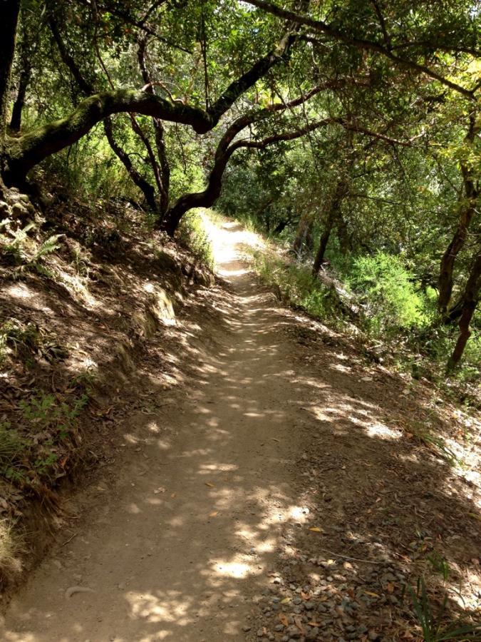
Start out with a nice warm up climb up a paved road, followed by nice sigletrack climb through some narrow switch-backs and some rock gardens. Levels out for some rolling singletrack. From here on, it is climb a little, enjoy some nice down hill. There are only 2 areas that I would call 'really technical' (THE switchback, and the boulder) but the rest of the trail will keep you on your toes, while still allowing your helmet to whistle in the wind. Since this is private property, you will either have to buy a day pass or a season pass at Don't try to poach, there are rangers out there most of the time.
 | Caballo Rojo | 1 mi | |
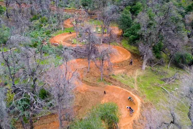
 | Flow Trail | 1 mi |


 2
2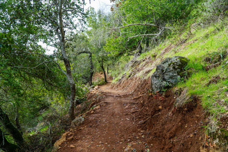


Good variety of terrain. Super thrilling to ride where it all started. Drop by the MTB Museum if you're out this way.
| ThankThis trail is very fun and one of my favorites though theres nothing extremely difficult so if your a biginer you can still do this trail also if you have time i definitely recommend doing the flow trail on your ride if you need food the deli makes good sandwiches and also has snacks and icecream if you need to rent i recomend sunshin bikes
| ThankFun loop ride, all singletrack and plenty of technical climbing with roots and rocks. I would award the ride 5 stars if it was a longer loop. Also note that there are no real fast sections as well, I think my peak speed for my ride was about 20mph on the road going back to my car. I was actually surprised that on a Saturday there weren't more riders there, while I saw a fair amount of other riders, I was never held up by anyone for an extended period of time. Area is beautiful and picturesque.
| ThankFlow/ pump track is awesome! Takes a bit of work or "pre-joy" to get there though, however it's worth it.
| ThankThis is a great loop near Fairfax. Very well maintained single track. There is a fun flow trail as well. Once your bored of china camp, this will give you a fun challenge.
| ThankLocal biking trails in Santa Rosa at Annadale were closed due to fire so decided to explore Camp Tamarancho. Spend some time learning about obtaining a day pass as the park is on private land. Also good to research parking. I was able to find 4 hour free parking downtown Fairfax. Sunshine bikes is often recommended both for parking as well purchasing a day pass for $5. I purchased my pass online and printed at home as I was hitting the trail early on a Monday. From downtown Fairfax, the ride into the park is pretty short and even a nice warm up before you start the initial climb up the Alchemist trail. This trail is a moderate climb with moderately tight switchbacks which will challenge your balance and technical climbing abilities over small rocks and roots. I was riding a hardtail which added a little more challenge but it was very reasonable and fun. Most climbs are in shaded areas with intermittent flats in the more exposed yet scenic vistas found on the main loop. There is a mixture of smooth trails, semi-rocky terrain, a rock garden, the boulder drop-off and finally the Enduro trail. The Enduro trail is a purpose constructed trail providing jumps and banked turns with a ton of fun in a short trail. Better yet, there is an opportunity to detour to the right off the main loop and repeat the Enduro traill as much as you like. Once your adrenalin has subsided you can finish the rest of the loop which is more of the same. At the end of the day, this is a great trail with mixture of terrain and fun for the low-intermediate to expert rider. Beginning riders should probably get some time negotiating rocks, roots, and crevices before heading to Camp Tamarancho. This trail is well suited for full suspension low to mid travel bikes but is reasonable for hard tail if you are willing to take a little abuse in the saddle. Not sure this is a downhill thrill but fun for everything else. Well worth the drive and the $5 usage fee. Definitely plan to return from time to time. Highly recommend a Monday as there were only few riders encountered. This trail is not designed to support a large number of riders and a crowd would definitely spoil some of the fun.
| ThankYes very true, a great town.
| ThankThis is a great place to go biking, with the flow trail, it adds the cherry on the cake. the only reason that I give it 4 stars is the accessibility to the trails, and the quality of the trails is ehhhhh.
| ThankVery cool place to ride. It has a little bit of everything from flowing singletrack to some more technical areas. Fun loop. I wish it was longer. Solid intermediate trail with some advanced sections. The flow trail is great! There are some amazing views, along with local wildlife too! I rented a bike from Sunshine Bicycles. They did an awesome job and I highly recommend them if you need to rent a bike.
| ThankAwesome trail! I love what they are doing in Marin. They climbs were tough but all climbable, and the switchbacks were tight. The descents were blasting and varied (everything from downhill flow trail to natural downhill). To make it even better, a quick ride past the Endor Trail puts you in the complex system of doubletrack winding of mount Tam's flanks. This puts you within range of a ride to the famous Repack.
| ThankThis place is AWESOME!!! The first part of the climb is quite technical with switchbacks, exposed rocks, and roots you have to crawl over!! One feature to look out for is "The Boulder" a rock drop-off!! Pretty cool nothing crazy but fun all the same. Wagon Wheel is where rocks slow you down!!! You can't go fast but have to slowly traverse through them... B-17 Extension is great for catching some higher speeds... and the best part.... Endor!!!-the flow trail. There are about two jumps between each burm, and you have to speed up to catch air off them.. IF you want to do the flow trail again you turn right at the bottom of the flow trail, then take the singletrack incline on your right instead of continuing on down the fire road. At the top are some wood features which are cool, enjoy yourself and be warned there is a slight chance of hikers... GO CLOCKWISE!!!! The best trail ever can't wait to come back,
| Thankand a recommendation go to China Camp to learn how to ride singletrack if you are a beginner, this is quite a bit harder than China Camp though...
The climb begins with very technical, winding singletrack. It then opens up and alternates between open hills and forest with singletrack. There is this one section called the Boulder, and it is very cool...just a small drop but very fun. This place reminds me of both Crockett Hills Regional Park and Santa Cruz. The trail called Wagon Wheel is extremely rocky and very fun... The B17 extension and Endor are both awesome sections! The flow trail is very well built and very thriliing! The wood features are fun to play around on...The climb out of here is pretty exhausting, but finishing off the ride with Alchemist which has some technical downhill and good switchbacks. Overall, I highly recommend this place and it is definitely worth paying the $5 day pass..
| ThankI only have a full DH bike and i was wondering if theres anyway to shuttle this trail?
| Thank4.5 - Great single tracks of varying skill levels and terrain (switchbacks, rock gardens, roots, etc.). The flow trail was awesome and I'm looking forward to returning. I'll probably wait for cooler weather though as I was sapped by the end (had to be well in the 90's). A little crowded - but mtb riders are generally good natured - and that's what I found as well (rode 8:30-11:30 on a very hot day).
| ThankThis gem is located in the heart of the Mt. Bike mecca. There are several types of ecosystems ranging from arid, redwoods to wetlands. The trail is well marked and in great shape. This is a trail you must experience. Make sure you go counter clockwise to maximize your enjoyment.
| Thank11/10 would fly through the bars again
| ThankFirst time riding in CA. Fun and nicely done. Not too technical, great ride
| ThankThe loop is great. Mixed flow and technical stuff. The views are good. Track is dry in some spots slightly tacky in others. Highly recommend it.
| ThankSweet and well maintained.
| ThankAmazing trails with several types of vegetation. I especially like the evergreen portion near the Endor flow trail.
| Thank