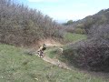
The Bonneville Shoreline Trail is a series of trails along the slope of the Wasatch Mountains where the old shoreline of Lake Bonneville met the hills. Good aerobic ride. Can be rideable in winter, but tread carefully. Great views of Salt Lake City and beyond! Can be busy. Descending Bobsled trails is the best option to leave the BST.
 | Bobsled | 7 mi |


 19
19
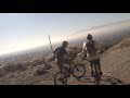
This is a fun, relatively short trail you can make in a loop. It also rides at a lower altitude and is easy to access. The trail has some challenges with long sustained climbs, tight switchbacks and some technical sections. The best part by far are the amazing views of the Salt Lake Valley and a fun but challenging finish down the Bobsled downhill.
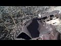
| ThankThis trail is cleverly built with many things mountain bikers like. I found parts of the trail to be pretty tough with deep erosion trenches toward the top and loose sand and dirt making it nearly impossible to stay upright. The berms and jumps at the bottom were awesome and the trail breaks off into multiple lines which allows for great variety. To me the trail seemed pretty advanced, so unless you're really confident in your riding ability, I'd tread lightly. Nevertheless, it's a great place to challenge yourself and push your skills.
| ThankVery fun trail, although muddy throughout a lot of the season. Definitely not for beginners. Met up with the guy who builds features on the trail, and he was pretty chill! Fun trail, lots of jumps, tons of berms, etc. I recommend going for an easy and relaxed run through the first time just to get a feel for the trail and see where all the features are.
| ThankClimb up, bomb down! Very fun! What more can I say. It's a great ride to do after work or if you don't have much time. If your visiting the area definitely check it out.
| ThankAs its name implies, Bobsled is a fast DH section off the BST. Super fun and pretty easy to do some laps.
| ThankOne of the most fun and exhilarating trails in northern utah. I've ridden it many times and it's always a great ride. The downhill is well worth the climb. And the view at the top is breathtaking.
| ThankThis trail is fantastic, love it! Hardcore riders can defy death on it, and less experienced riders will also have fun (though definitely not a trail for beginners). I'd recommend taking it fairly easy first time down just to familiarize yourself with its ins and outs and then hit it up again for reals. I say this because there are some very serious drops/jumps for the unaware.
| ThankBeen riding bobsled the last few months with the weak winter. Everything is super fast and smooth the mega rut at the top has filled in and there is very little water present. Unnfourtunatly the sweet bench that marked the top of the trail is gone.
| Thank8/25/2011 about 1/3 or so of Bobsled is messed up because of a rut from water spring thats running down it after you get past that its mostly ok but still a lil funky. would be great if not for the 6inch to 2 foot high rut that has developed since I guess 3 months ago.
| ThankRippin' fun decent off the BST. I highly recommend it!
| ThankFast moderately difficult downhill. Lots of features on the trail! Rode 4/16/10 and it was about 95% dry and 100% good to ride.
| ThankWhat a great ride and such nice scenery. The Bobsled is definitely the payoff for all the work put into the the first part of the trail. The whole Bonneville Shoreline is absolutely worth it although be careful of on-coming traffic. Be Noisy!!!
| Thankgreat downhill! thanks to local steve newton for the new entrance. fantastic singletrack getting there via the bonneville shoreline trail. hikers frequent this trail, so BEWARE, also ON-COMING BIKER TRAFFIC.
| ThankMany super sick mods made spring of 2007. This trail keeps getting better with age.
| Thank