
I recently returned from a long road trip to The Mighty 5 National Parks in Utah, including Bryce Canyon, and I made it a point to ride my mountain bike in every single destination.
See Also: The Mighty 5: Mountain Biking near Utah’s National Parks
After some serious research, Thunder Mountain seemed like the only legitimate mountain bike trail close to Bryce Canyon, so I set out to explore it on my own, hoping that the internet reviews were accurate. There are no bike shops anywhere near Hatch or Panguitch, where Thunder Mountain is located, so riders are really forced to rely on reviews like this one for the scoop.


Thunder Mountain is located in Red Canyon, about 10 miles west of Bryce Canyon on Hwy 12. Probably the most important thing you need to know before embarking on this trail is that it is best ridden from east to west. You could ride it as an out-and-back, but the western end of Thunder Mountain would be a brutally-steep climb. Therefore, I think it is either best done as a shuttle, or by making a loop using the SR-12 bike path that parallels Hwy 12.

In the interest of time (and impending foul weather), I elected to shuttle it. You can start at the Coyote Hollow Trailhead just off of Hwy 12, or drive about two miles up Coyote Hollow Road (a dirt road) to where the trail actually starts, aptly-named “Thunder Mountain Trailhead.”

The trailhead is located at 8,077 feet, and the trail begins with a gentle climb on red dirt sounded by pines and desert flora. A front was moving in on me quickly, so I made haste and didn’t stop for a lot of photos.
The first 4.2 miles of this trail are relatively smooth and flowy, with some fairly fast downhills on buff terrain, followed by some gradual climbs that take about 10 minutes or less. There are two notable steep climbing sections, both short, but steep enough that many riders may need to get off and walk due to the grade. The first is about 2.6 miles in, with a grade ranging from 18-24%. It’s a doozy, but it’s doable if you torque up and pedal. The second comes at about 3.6 miles in, consists of about a mile of climbing, and also has a section that is 24%. After that, though, it’s almost all downhill… so hang in there.

There is a point where the scenery changes dramatically: you’ll emerge from the forest, and the landscape will start to feel more open as you approach a ridgeline. When you see the first two, very large, orange hoodoos, you can rest assured that the downhill fun is about to begin. As you hit the pinnacle of the ridgeline at about mile 4.2 (8,270ft), breathtaking views of a multi-colored desert canyon are short-lived before the trail turns decidedly down. In fact, aside from two very short climbs at mile 5.0 and mile 5.7, it is almost all downhill, with grades often -14% to -18%… and that is steep, my friends!

I went into this ride thinking that Thunder Mountain was a buff trail with a few steep sections but assuming, based on reviews, that it was squarely an intermediate belt of singletrack. For the most part that is true, and I think any confident intermediate rider would have no problem with most of this trail, but there are a few sections that will give any non-seasoned rider pause.
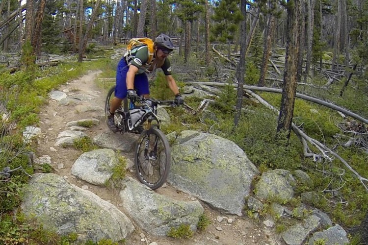
Between mile 5 and 6.6, for example there are some tight, rocky switchbacks that are honestly pretty hard to make. They are easily-ridable for the experienced, and certainly walkable, but not exactly “intermediate” in my opinion. They were a blast for anyone that likes ripping down steep, gnarly, twisty trails–so I would do them a hundred times over. The only bummer is that the scenery is gorgeous here, and you hardly get to look at it because the trail demands 100% of your attention.

After this section, there is a very photogenic area of large hoodoos and deep orange and red-colored rocks. The trail follows a narrow, picturesque ridge that reminded me a lot of Zippity Doo Dah in Fruita (if that trail could be transplanted on Mars), before dropping another short series of tight, fast switchbacks into a creek bed. Despite being on the very edge of a system of wet snow and sleet at the end of winter, the trail was tacky-dry and the creek bed had no running water. The trail continues on the other side of the creek and is easily visible as you pedal up a short climb to an intersection. Keep right here, and you will climb another 2-3 minutes before topping another small hill under tree cover.

Your final effort will be duly-rewarded at the top of that little climb with a screaming-fast, mostly-straight, downhill section littered with little kickers. My max speed was 28mph on this section, and had I known the trail, I could have and would have opened it up quite a bit more. Still, braaap! What a ride!

This downhill took several minutes and was the perfect way to end this ride, as it spits you out in a parking lot on Hwy 12, about 1/2 mile west of the Red Canyon Visitor Center, where they have water and restrooms. This is a great place for a shuttle pickup or, if you are looping it, catching the Red Canyon Bike Path eastbound back to Coyote Hollow.

Thunder Mountain is a hidden gem in the heart of Utah. You may never have opportunity to access it unless you plan a trip to Bryce or just happen to be passing through, but it is well worth the ride if you can make it happen!


3 Comments
May 31, 2016
Jun 6, 2016
Jun 12, 2016
Another place not far that I wish to explore is Fish Lake and the Mytoge Mountain singletrack. Kit Carson said in the 1830s that there were so many fish in the streams feeing the lake you could walk across their backs and stay dry. Bring a fishin' pole.