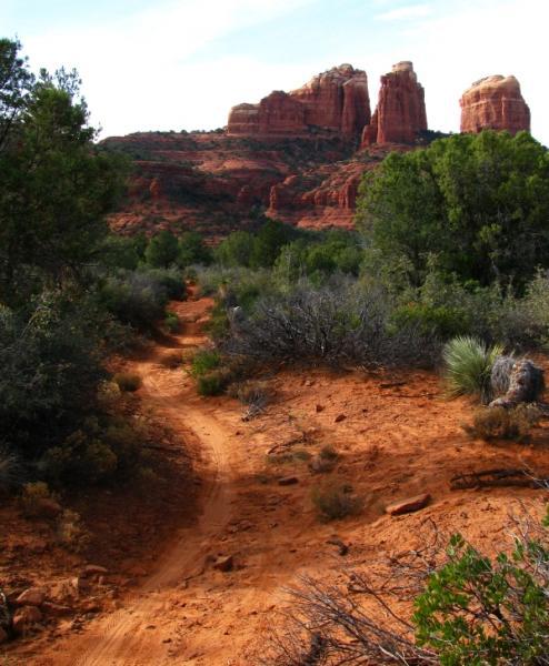
This challenging, fun & exciting singletrack rewards you with some of the most scenic vistas of the Sedona area. Leaving the B.R. Pathway you twist & turn downhill through the forest and two tunnels under highway 179, a fast ride through the forest with great flow! At 1 mi there is an intersection with the HT tr, an alternate route to the B. R. Pathway, stay left here and follow the trail as it climbs and descends through the forest to the base of the Cathedral Rock. The trail turns more to slick rock and follows the contour of the mountain north sometimes a bit technical and exposed in some places. 1.5 mi later you will reach a large open, slickrock point & the intersection with the Cathedral Rock Tr, a hiking trail that starts at Back O'beyond rd and goes straight up the mountain. The ride gets more technical from here on so if your not up for it this is a good place to take a break and then head back.
.5 mi past the Cathedral Rk tr you will go down a set of technical switchbacks to the river and follow it for another .5 mi. At an open field with a fence you will come to the 2.2 mi Baldwin tr and the beginning of the loop, although do-able either direction I recommend doing this counter-clockwise. Staying left at a couple intersections takes you to the top, around the mountain and back down to the river. This a very fun but challenging trail, once back at the river follow the Templeton trail back to the starting point.


Rode in from the Yaivapai TH. Beautiful ride to Cathedral rock, not hard. However, going downhill to the river is very difficult. Wish I had turned to Easy Breezy trail. From Cathedral rock to the creek is also full of hikers whereas before you get there was almost empty
| ThankThis is a very good all-rounder for the Sedona area. There's slick rock, there's vista's with stunning views, there's wooded creekside sections, there's some challenging technical sections to keep it interesting but not too difficult to the point of having to walk your bike a lot.
| ThankVaried Sedona singletrack that incorporates a lot of slickrock sections in the shadow of Cathedral Rock, technical climbs/descents, and a beautiful run along Oak Creek.
| ThankGreat trail to get introduced to Sedona. Nice mix of fun and tech. Gets a lot of traffic with other riders and hikers.
| ThankVery fun riding.
| ThankLoved it. Rode Templeton after Hiline and Baldwin. Spectacular views. Moderate to heavy hiker traffic. Great way to end the day.
| ThankGreat chunky trail, with stellar views!
| ThankOk. First of all, I'm a very advanced xc mtn biker. This trail is not intermediate if you add the baldwin loop. Which is also required for the water part. It is also not 400 ft of climbing or 10 miles long. It is 1349 ft of climbing and 13 miles from the bell rock parkway parking lot. I.e the instructions arent exactly correct. If you start at bell parkway you head up hill first for a mile and half before dropping under the bridges. Anyway, this ride is really awesome, but be prepared for some climbing and technical, especially is you do the baldwin loop.
| ThankGreat singletrack that has something for everyone (flow, rocks, techy spots, small ledges). I didn't encounter the tourist problem, but I see how it might be an issue in the spring or fall. Don't avoid the trail if you're here in the summer - just ride early in the morning or late at night. If you connect this trail with Slim Shady from Oak Creek, its about a 2.5 hr ride (Slim Shady -> Templeton -> Baldwin).
| ThankFun trail with a lot of different features to challenge you. Some fun red rock type riding, similar to moab, some soft sandy spots, and a few techy spots to keep you on your toes. nothing super technical though. def a great trail to hit if you are in the area. lots of trails in this network to piece together to increase the distance of the ride. awesome scenary.
| ThankVisually stunning, get to this one early in the day as there are lots of toursits walking on this trail. Any ride near water in AZ is a treat.
| ThankOnly reason I give it only 4 stars is the crowds.
Ok, the trail ain't bad. Rocks, sandy spots, some drops and jumps makes it a good ride if you live near. But due to the enormous number of tourists on this trails it makes near impossible to ride it. It's probably a good idea to start with first sunrays and get it done quickly. And then go to Moab and have real fun.
| ThankA premier ride in Sedona. Excellent singletrack transitioning to slickrock with stunning views. A must ride.
| ThankA great mix of technical, single track and climbs....hardest part was keeping your eyes on the trail in front of you as the scenery unfolds around you.
| ThankThis was an awesome ride. The descent into Oak Creek is a bit hairy and a little beyond what my ability was, so I would give that part a black diamond. But the scenery was incredible.
| ThankIf I only rode one trail in sedona this would be it. Park in oak creek across the street from bike and bean. Lots of true singletrack. Ride to baldwin loop and do it or not, out and back or with baldwin lollipop. Fun stuff, within about 2 minutes you go from riding red slickrock to forested singletrack along the oak creek. Pretty rocky along the creek but clearable for only the best. Enjoy the riding, watch out for others as traffic moves both directions. * Review edited 5/10/2010
| ThankGreat mix of singletrack and slickrock. Nothing to hard except maybe the switchbacks down to the creek, a slip here could send you doing cartwheels head over heels down the cliffs, totally do-able, just don't be stupid.
| ThankOver 3 days in Sedona, I covered about 60 miles of outstanding trails--this was my favorite. The combination of stunning scenery, sweet singletrack and superb slickrock made this a real gem. The ride along the slickrock bench as you approach Cathedral Rock is way beyond cool and the super-technical switchback descent to Buddah Beach isbeyond description. Just when you think you've had more fun than anyone deserves in a single day, you hit Baldwin with it's super cool technical climbs and descents in the shadow of the other side of Cathedral Rock. This one truly rocks!* Review edited 3/28/2009
| ThankI realize this description may seem a bit confusing, its not really, just go ride. I do however advise getting a good map at one of the local bike shops as there are many options & trails in this area. Carry lots of water in the summer and be wary of other trail users.
| Thank