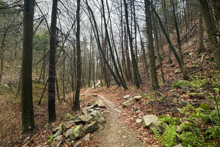
A 100-mile network of 80% singletrack trails run through the Rothrock State Forest. The tracks have great technical and flow sections. There is 4,463' ascent and -4,458' descent,
 | Beautiful | 1 mi | |
 | Brush Ridge | 4 mi | |
| Chestnut Spring | 1 mi | |
 | Coopers Gap Epic | 27 mi | |
| Croyle Run | 2 mi | |
| Deer Tick | 2 mi | |
| Detweiler Run Road | 4 mi | |
| Gettis Ridge Road | 2 mi | |
| Lonberger Path | 2 mi | |
| Long Mountain Trail | 3 mi | |
| Lower Trail Connector | 1 mi | |
| North Meadows Road | 2 mi | |
| Old Laurel Run | 1 mi | |
| Pig Pile Trail | 2 mi | |
| Ross Trail | 2 mi | |
| Sassafras Trail | 1 mi | |
| Sassafras XX | 2 mi | |
| The Raven | 12 mi | |
| Three Bridges Trail | 0 mi | |
| Tussey Mountain Trail | 9 mi | |
| Wildcat Gap | 1 mi |


 1
1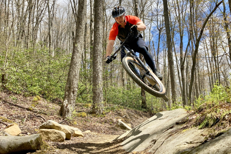


I grew up next to Rothrock and love these trails. Cell service is spotty and I highly recommend taking a Purple Lizard map, which you can get at the Bicycle Shop in State College or Rothrock Outfitters in Huntingdon. As the Purple Lizard map says, there are no easy trails in Rothrock. If you are looking for a challenge, you can find it here. Uphill rock gardens, downhill rock gardens, you name it. The Cooper's Gap area with Chicken Peter, Dutch Alvin, Lingle Valley, etc. is a blast. I like to work gravel roads into a ride for elevation gain, then descend on singletrack. There are enough rock gardens in these trails that hopping off the singletrack onto a 1000' feet gravel climb feels like a relaxing break. Ross and Peep are a couple of trails that work great for accessing with a gravel road climb.
It's typical to see few other riders out in Rothrock. It's in a rural area and has substantial skills barriers and fitness barriers to riding it. I've never flatted here, but you'll be in the middle of nowhere so it's important to take flat repair kit, tools, spare tube, etc.
| ThankI love this trail, but a minor fuck up on the bridges has cost me and several others a derailleur hanger from time to time. Great ride, but the rock garden before the bridges is an absolute enigma for me.
| ThankYou will get worked, but just as you are about to bag it, quit, stop, cry, curse, break a bone, smash your knee into your handle bars, crunch your nuts off your top tube, or endo into a geologically funky rock garden...Rothrock concedes and sends you on a ripping downhill, flowing single tracks, or out the other side of a monstrous rock garden and just as you fall back in love with mountain biking Rothrock bitch slaps you up a steep, rocky, never ending death march climb. What a trail.
It is a massive system. I like to camp at Penn Roosevelt (Primitive) and hit the trails in that section...Sassafras to Pig Pile trail is a good time.
| ThankAs with most of Rothrock, it's rocky but loads of fun; challenging with awesome vistas to enjoy when you stop. Tough to look when you're hopping rocks!
| ThankThis review is for Lower Trail and Bald Knob Ridge only. Not going to lie, I was unprepared. As a fairly travelled expert rider, I found these trails to completely catch me off guard, I entered Lower trail off Laurel Run Road and it started off fast, flowy and totally fun. However Lower trail soon became extremely technical, as in rocky to the next level and by the end it was seriously 500 meters an hour and big rings hitting rocks every 2 seconds. Next I took Bald Knob Ridge eastbound, which started off with taking my bike for a walk through the woods but once you get to the top it's super technical, but rideable. After that I hit SandSpring which was a decent technical. Overall good times were had but I would label it as adventure riding because the trails are not very well marked so be careful.
| ThankLittle bit of everything here. Especially rocks. Some tough climbs, but the grades aren't overly steep.
| ThankExcellent singletrack, assuming you like rocks. Rocks, rocks, rocks, everywhere. It's such a huge trail system it really should be broken into individual sections.
Some of the highlights are John Wert, it's about 2.5 miles long and pretty flat, but it's one long rock garden. It's insane.
The crown jewel of the system is by far, Tussey Ridge. It's around 4 miles long, super techy, and yes, rocky. The top of the mountain burned (I think?) a few years back, so there are no trees up there. This gives you great views of the other nearby ridges.
Overall, Rothrock has some top notch riding.
| ThankRothrock is far too large to really review in a single entry. These entries seem to be for a single trails or at most, a trail system of nearly uniform trails. Rothrock trails range from wonderful to ok. As a past local, I miss the whole of Rothrock riding greatly, so maybe that is the best review.
| ThankBench mark trail in Rothrock State Forest
| ThankSkinny hiking style trail. There were a lot of rocks, and it was a bumpy ride. I ride a hardtail, and I would definitely recommend a full suspension. Fun overall.
| ThankAwesome trails! Did the IMBA Epic per the MTB Project website. Pretty well marked w/ signs at many trailheads. Some flow, lots of rocks, nothing too tech but enough to keep you on your toes. A few big climbs but all mtb friendly if you have the legs/lungs. *Note that this epic is more like 30 miles, not 26 as MTB Project states... we ran out of light and had to cut it a little short. Also "Flat Rock Trail" is boring double track... considering skipping it by riding all of Sassafras trail instead. Have to look at a map. The Rothrock "Purple Lizard" map is really helpful here (and Tussey Mtn Trails next mountain over)
| ThankRode they Coopers Gap Highlights system with my son. We made a diversion for some great trail riding on our trip from Wisconsin to New York. These trails did not disappoint!
| ThankGreat trail system! TONS of rocks, and lots of roots to boot! A real challenge. But fun as heck. We both loved it.
Super rocky. Super rooty where is is not rocky. Some fun flow bits. Great views. A real fun trail.
Huge kudos to the folks who make this trail happen. A great trail looks like it is natural and just flows, even when it is difficult. It takes a lot of work to get this kind of quality. Thanks for all your work!
Great ride if you love Rocks and technical riding. This is definitely an advanced ride I had to walk through a few sections as the rocks are tombstones and boulders in some sections. I did have a ton of pedal strikes along the way.
I bought a purple Lizard map and learned as I rode. You can get one at Rothrock outfitter in town. This map comes in handy and it is waterproof. Take it with you as it can be confusing up on the mountain.
I rode the opposite direction as the below route Which made for some steep rocky climbs. I feel I gained some new skills on this ride.I do wish I had brought my full suspension bike instead of the hardtail.
I suffered a pinch flat . However the views from the ridge where worth the climb.
I met a group of local riders a judge ,lawyer and a engineer, they gave me much needed directions to get back over the private land.
I was welcomed back at the parking lot by them with some ice cold beverages and great conversations.
| ThankNice meeting you guys.
sick place. tussey ridge trail is a must do.
| ThankGets rough and technical the closer one gets to the Shingletown Parking area
| ThankThe name says it all. It's a must-ride for those visiting Rothrock State Forest.
| ThankMaybe one of the best views of any trail in the area, especially in the burn zone. Moderate easy climb up the end of the ridge, and then a rocky, technical ride out the spine of the ridge.
| ThankCooper's gap has it all. Heart pounding climbs, rock gardens, hair raising descents, beautiful views and more. Check it out--Pennsylvania Mountain biking at its best!
| ThankI've only been mountain biking for about a year but this is the best loop I've ever ridden. I mostly ride the trails around Philly, i.e. the Wiss and White Clay in Delaware. Cooper's Gap has quite a bit of elevation change and a huge variety of singletrack. It starts out fairly smooth with an easy ascent and fast descent down Dutch Alvin Trail. Peep Trail has a fair number of rock gardens as you wind your way up a hill and ends with a long climb up to the road. After a relatively brief road climb, Sassafras Trail is so narrow and brushy that you might think you've gone the wrong way (we did), but it opens up for some great flow and rock gardens and you pass a gorgeous lookout. Descending down Pigpie is an absolute blast, pretty much the most fun I've ever had on a mountain bike. Finally, Sass-XX trail is gorgeous and flowy as you drop through the woods to a creek and then climb back up to Coopers Gap Road. Highly recommended.
| ThankToo much small narrow rock for my liking. I much prefer Moraines larger Rock gardens but that just me
| Thank