This trail is a combination of a network of trails. I rode it counter clockwise. I starts out with the Gould Rim, then on to the JEM trail, and finally to Hurricane Rim. This is a great intermediate ride. Very fast, rolling hills. Not a lot of climbing. If you dont want to do the whole 21 miles, consider just doing the JEM trail out and back.
Description from justin70:
This trail is a combination of trails. It is usually ridden counter-clockwise, so that the JEM trail is ridden down-hill. There are a number of trail heads that can be used.
By doing the whole network (Hurricane Rim, Gould's Rim, JEM Trail), you get a 22 mile epic cross country loop.
I recommend parking at the Virgin trailhead for JEM - that way, you get to finish the ride with JEM, which has the best flow, is the funnest of the three, and is primarily downhill.
Turn right off of State Road 9 onto Sheep Bridge Road just before you enter Virgin, Utah. Cross the Virgin River and take the first right after the cattle guard. Follow the two track to the end (this is the trailhead).
Start riding going west on the Hurricane Rim, which has the most technical bits and the biggest climb. Transition to the Gould's Rim, which has some tech, some doubletrack, and some flowy BMX-style ups and downs. Then finish with the JEM, which is a mostly big-ring affair, except for the one very technical drop from the top into the wash.
This trail as a loop demands respect. It includes rocks, distance, desert weather, vertical exposure and remoteness. Take adequate food, water and spares and ride with care.


 4
4
Trail was in very dry & dusty condition
| ThankOne of my favorites. great loop when combined with Goulds and Hurricane rim trails from Hurricane Over the Edge bike shop
| ThankGreat trail. Nice downhill flow when combined with Goulds Rim and Goulds trail. A couple of technical downhills that I actually walked the bike down. Ya...not a proud moment. Overall very flowy and enjoyable!
| ThankRode it as part of a long loop starting in town: Goulds-JEM-Hurricane Rim. J.E.M is definitely best ridden downhill (doing the loop counter-clockwise). If you're tired after some punishing days on the mesas, or you don't have slickrock back home and want to try something a bit more familiar, this flowy fun trail will be just what the doctor ordered.
| ThankAwesome trail (especially hurricane rim), and a testing ride to complete.
Very aware of exposure and mechanical risks ... A long way from rescue at times. Be prepared.
| ThankHmmm....and IMBA Epic rated #857? This isn't my favorite trail in the area but it's still a must-do in my opinion. We like to go ride til' we're toast on another trail and shuttle the JEM from the top. When the wind is at your back, this trail is a pure roller coaster and in my Top 10 of all rides, it's that good. Nice variety of scenery and challenge with a littl exposure thrown into the mix for good measure.
| ThankFun trail, rode it New Years day 2014
| ThankButtery smooth through the desert. Make sure you go DOWN the trail rather than climbing it. Park by the river and link together JEM, jeep roads and Sheepsbridge Road for the climb, catch a little of Gould's on the other side of the highway and then hit JEM for some fun downhill. At times, I wished for a tad more gradient, but plenty of fun. A bit of exposure at the bottom next to the river.
| ThankRode out on the Jem trail and did the whole loop, but due to the long section of road I would recommend doing it as an out and back, fun and flowy and not too technical at all.
| ThankJEM is just below Gooseberry Mesa. If you find the mesa tough this may be your heaven. It's a much mellower trail with a few descents to add tech but all are walkable. It's pretty desert scenery with edible wolfberries around June. Mostly dirt trail with some rocks but mostly farily smooth trail.
| ThankEasy and pleasant ride. If you only have time for one ride near Hurricane (bad planning on your part), skip this and go up on Gooseberry Mesa. this is a better choice for intermediate-level riders, though.
| ThankIf you don’t have the time or legs to do the whole epic 21-mile loop incorporating the Gould Rim and the Hurricane Rim along with the JEM Trail, this is a pleasant and shorter alternative route to do the JEM Trail.
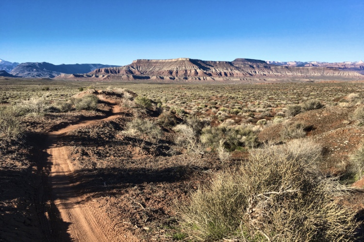
The J.E.M. Trail is just west of the town of Virgin near Hurricane and Zion National Park. This trail offers high-speed desert cruising and a scenic cliff- side ride along the Virgin River.
This 12.8 mile route begins on double-track and returns on the JEM singletrack which is mostly downhill. If intermediate-level riders walk a short but tricky switchback section, most of the ride is not technical – just fast and fun.
From the TH backtrack 0.2 miles and turn right on the main gravel road. At 2.1 miles you’ll drop through a big wash. Continue up the hill on the far side of the wash. At mile 2.44 turn left onto a dirt, double-track road. Follow this DT as it winds its way towards the base of Gooseberry Mesa. It will follow a wash for a ways, goes past an old corral and through a gate.
At mile 4.36 the road forks. Go right. At mile 5.16 you’ll go through another gate. At mile 6.57 the (signed) JEM trail crosses the road. Turn right and fasten your seat belt.
At mile 7.1 the trail descends the cliff with a couple tricky switchbacks. Many riders will choose to walk this short segment. At mile 11.08 the trail forks. Go right (left will take you to Hurricane Rim). At mile 11.4 the trail intersects a doubletrack at a wash. Turn right, cross the wash and some rock until you see the trail continue on your left. Follow the trail as it skirts the edge of the wash and the Virgin River. At mile 12.81 you return to the TH.
| ThankFrom starting the JEM trail on the Hurricane side it was simply a blast. Not to technical, but the flow was impressive and a great start for beginner riders. It does have anywhere from 75-90 foot drop offs to the left into the Virgin River. It is no wonder why it is rated one of the top flow trails in the nation.
| ThankBy doing the whole network (Hurricane Rim, Gould's Rim, JEM Trail), you get a 22 mile near epic loop. I recommend turning on the dirt road a couplemiles before the JEM trailhead and taking it to the end of JEM, which is also where the Hurricane Rim begins. That way, you get to finish the ride with JEM, which has the best flow, is the funnest of the three, and is primarily downhill. Start out going west on the Hurricane Rim, which has the most tech bits and the biggest climb. Transition to the Gould's Rim, which has some tech, some doubletrack, and some flowy BMX-style ups and downs. Then finish with the JEM, which is a mostly big-ring affair, except for the one very technical drop from the top into the wash. I thought this loop was somewhat overrated, but still well worth doing.
| ThankJEM rips! Especially if the trail is tacky and no wind. You are in Hurricane. Fast and flowing, this trail is a must do for singletrack enthusiists.
| ThankPretty fun singletrack network, best after they have had some rain though, can get quite loose and dusty.
| Thank