
Everyone defines their perfect MTB road trip differently. For some, it might be stringing together a long loop of mountain bike trails at different locations to drive to and hit, one after another. For others, it might be driving cross-country non-stop to reach a destination that has enough singletrack to fill a full week of vacation time. For still others, it might be a combination of the two.
This summer my wife and I are going on an epic road trip. This road trip is so epic that we don’t even know for certain how long it will be or how many trails we will ride yet. However, we do have a plan in place about where we will start, and here’s how we went about getting to this point.

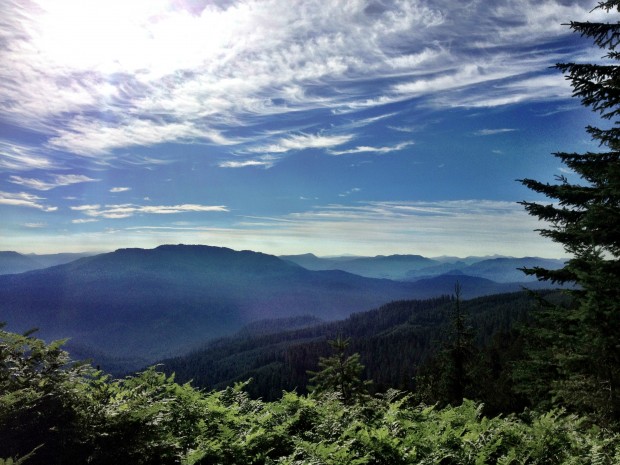
The view from Porcupine Rim, one of the trails I’ll get to ride this summer. Photo: maddslacker.
Getting Started
To figure out which approach you want to take when planning your road trip, start by determining your purpose. Do you want to ride epic downhill, desert slickrock, high alpine lung busters, or something else? The primary focus of our trip is to visit the San Francisco Bay area and the Los Angeles area to ride trails that aren’t already in the Singletracks.com database. As a result, our destination was already chosen for us.
While those are our main destinations and we will be spending a significant amount of time at each of them, along the way we are definitely going to add in a number of different trails. To figure out exactly which trails to ride and which to skip, I started with the list of the best mountain bike trails in the world. While we are going to be spending some time in Colorado and driving through Utah on our way to California, we are obviously going to have to skip over some really amazing trails. However, one thing I decided that we could not do is just drive past a trail that is on the top 10 list. Turns out, our path is taking us near a lot of top 10 trails that I had never ridden before: Porcupine Rim, Slickrock, and 18 Road Trails. I am definitely going to sink my tires into the dirt at each of those trails!
We are also going to visit a couple of spots that are close to the top 10 list but not quite on it, including Park City and Downieville. There are a few spots that we probably won’t be able to fit in, such as the Tahoe area. While those trails might wind up on a list of regrets, we can at least take solace in the fact that we are still young and have our whole life ahead of us to travel to these places another time (Lord willing)!
The Destination
Once you reach the destination where you want to spend some serious time, how exactly are you supposed to pick which trails to ride and when? Obviously, starting with the Singletracks.com database and choosing some of the highest-rated trails is the best idea, but what if there is an area that is really dense with trails, there are tons that you have to choose from, and you need to remember which ones to ride?
Well, I developed a little system using Google Maps that works pretty well. In case you weren’t aware, if you have a Google account you can create and save custom maps with various place markers. I took the data for the trails I wanted to ride in each specific area (SF Bay and LA) and created two different Google maps. After plotting all the points, it’s easy to see exactly which trails could be ridden together on which days. Of course, the searchable Google map on Singletracks does that for you, but plotting hand-picked trails on your own map will eliminate distractions and clutter from trails that you have decided, for one reason or another, not to ride.
For instance, here’s a screenshot of my Bay Area riding plan:

As you can see, I have categorized the trail markers using different colors. For you, perhaps green will be the best trails, blue the second best, and red the worst, etc. On my map, I categorized the trails by the amount of information we have on Singletracks: green for the most (and so good that we can’t skip over them), blue for some information but not enough, and red for none. As a result, the red and blue trails are my priority. As you can see, there aren’t very many red trails on this map, so LA is actually even more of a priority than the Bay Area:

After plotting the trails and seeing where they were located, I visited Tripleblaze.com and researched a few quality campgrounds that would be centrally located to the trails I wanted to ride, and also added those to the map as well. If there are other attractions or things you want to do while on vacation, you could definitely add those to the map as well, using different icons, and presto! you have a digital game plan for your vacation!
Moving Forward
The big question mark in our personal plan this summer is what happens after we leave LA. Right now we are tentatively planning on spending a few days in Big Bear and making that a mini destination all its own. However, we might have much more time than we initially thought, so there are still some decisions to be made.
Watch this space–I will keep you all updated as plans develop, and look for regular blog posts this summer as we travel the nation!
Your Turn: What’s your idea of the perfect road trip?


22 Comments
May 29, 2012
May 29, 2012
@abegold, thanks for the advice. Do you know of a good campground in the Angeles National Forest front country that you'd recommend?
@Luke_E, thanks for the recommendation, I'll be sure to check it out!
May 29, 2012
May 29, 2012
Prepare for poison ivy at CA trails by water if allergic. Diluted chlorine or just washing after riding thru it usually works, hot tub! Beware of goatheads, too. They cause flats.
Get exact trail head directions, couldn't find the trailhead for the Forest of Nisene Marks and the bike shop in Santa Cruz wasn't helpful.
Downieville rocks, cool, fun and beautiful. Plan on taking a swim in one of the many trail side pools as your elevation lowers down the trail.
May 30, 2012
Ive had just a little experience at the road trip myself- I have all kinds of tips and advise for you and what I see as speed bumps in your plan, but; You guys will develop your own tripping style and the way you like to do things, experience is the best teacher.
How you view just being out there will make or break what you view as a successful trip in the end. Years from now it won't be about how many trails you rode or places you got to see.
People, although enjoying the same things can be very different, my cousin and I are like this- love the doing the same things and the same kind of country. But he is more of a destination guy where I am a journey person. He will bust his butt frantically with to-do's and drive 100mph to get to a destination to 'be there'. I on the other hand start with a pretty loose idea of where I am going, what Im doing and how it will take- as soon as I back out of the driveway 'I am there' already.
We can't wait to tear about your adventures buddy!
Jun 1, 2012
If you guys take the I-40 route back from LA and want to check out some of the Albuquerque area trails I'd be happy to give some recommendations or be a tour guide.
May 29, 2012
Glad we'll be able to overlap our travel plans a bit so we can ride with Corey in Colorado next week. Road trip!
May 29, 2012
May 29, 2012
Yeah, those pics of Switchgrass sold me - looks very cool.
May 29, 2012
May 30, 2012
May 29, 2012
He's been a blast to follow. Great writing and incredible insight into the past and present bike industry, plus I hear he can really shred. He lives in the Bay area, if you wanted to get the local scoop on trails I would recommend shooting him a note.
May 30, 2012
May 31, 2012
May 30, 2012
May 29, 2012
May 29, 2012
Jun 1, 2012
May 29, 2012
May 29, 2012
May 30, 2012
May 30, 2012
And thanks for the tip on the google maps. I'll definitely be using that in the future.
Thanks for the tip on the biking blob, Luke_E. I need some decent time killers :D