difficulty: Advanced. Best trail in southern LA. It is hard.. that is why it is called the Beast. Big climbs, they never stop... the whole trails is a massive climb, some of the drops are very fun. You need technical skills. The downhills curve and go over trees, bridges, roots. You will have an awesome time...
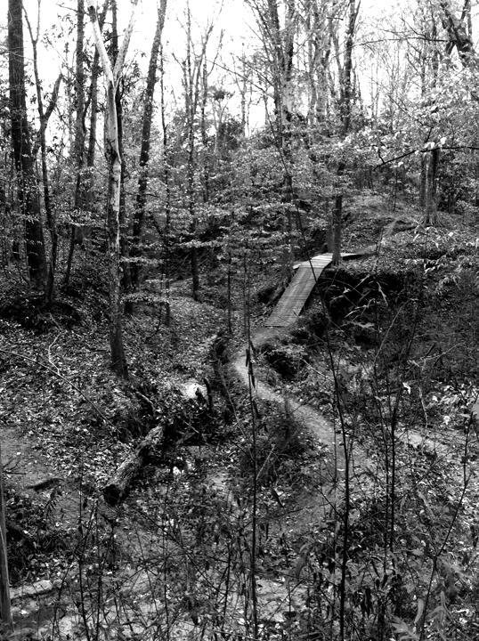
This trail was begun but unfinished by the same bloke who did the great trail system in Ruston, LA (Lincoln Parish Park), James Ramsaur. It was completely destroyed by Hurricanes Katrina and Gustav. Beginning again in 2008, Lynn Gray, with the help of friends, designed, rebuilt, and completed a 6 mile loop with 16 bridges, bench cuts, and other new features.
The trail ducks in and out of the woods surrounding the park. 95% twisting technical wooded singletrack. A couple short sections of double track. Many twisting, steep rooty off-camber hills. Good elevation change for Louisiana. Great semi-technical downhills. Trail is decently marked and follows a single loop.


 13
13
Not a mountain biking trail at all. This is not maintained and needs serious work. Spent more timing walking over trees and avoiding pits. Sand was interesting too... even at the bottom of a steep hill, when you would traditionally speed up to get up. All that being said, it would be great if it had work done to it. Hoping BRAMBA can help! :)
| ThankVery challenging trail, steep climbs with serious roots to navigate. It's probably a lot more fun in the spring and early fall when it isn't so leaf covered. Unfortunately the trail is a little in disrepair and not the easiest to navigate. Still worth checking out if you're in the area and up for a challenge.
| ThankLove it! Up or down always, lots of challenging roots. The entire trail is a puzzle to be figured out.
| ThankFortunately, to some, there is nothing like The Beast in Louisiana, nor in Mississippi. It most closely resembles the technical trails around the Austin and San Antonio areas of Texas, but instead of rocks, the roots provide technical challenges. If you haven't ridden more challenging trails locally, you're in for a rude awakening. However, The Beast is a lot of fun once you solve all of its technical puzzles. Just relax, take a deep breath, and drop in!
| ThankThe overall trail is very dangerous and not well maintained the trail has to be the worst in La next to Hooper trail. They even have you riding behind an archery range without any warning to the archers shooting arrows at you. The other problem is that they have dangerous drops on both side of of a single foot track that is deadly if you fall along with roots very difficult to maneuver. The descents are also met with pot holes and at the bottom that catch the front tire and have you got otc. The climes are also much worse as they are full of high roots that hit the pedal. im a experienced rider and most of my time was spent walking with the bike. i would recommend mt Zion as a way better trail or a comite with anything in the top 3 in Louisiana but the beast is one to avoid.
| ThankSo upon making the decision to buy a boat from a guy in nearby town of Hammond, my brother and I made a long weekend of the trip and stopped at a couple MTB parks along the way from Miami Florida.
Today we road "the beast"
Nestled in a corner of the park, the trailhead is clearly marked and allowed us to park rite next to it. Starting the trails you quickly get a taste of what "The Beast" has to offer with short drops and tough root climbs. The single track is nice and compact in 95% of what we road making it smooth and fun until you get to the crazy climbs and challenging drops covers in roots and small steps. There are a bunch of small wood bridges connecting the giant loop in areas where there would be washout making it nice that you don't have to stop and hike-a-bike over them. The drops will get you going with plenty of speed on the descents but it will mostly be followed by longer winding climbs or short quick changing root fill ones. The trail dose have some flow but the sharp turns with no berms make you loose a lot of speed.
My brother and I did loose the trail at the point where the trail turns back on itself by at the end of the baseball fields where you can see the skate ramps in the distance. There was no clear sign to let us know where to go. Unfortunately we realized our mistake once we got back to the truck and began to ride the trail backwards. (No one was on the trails but us, otherwise we wouldn't have done this.)
Overall we did enjoy ourself enough to say that if we are ever passing by again... It's worth the stop.
Great job by the local trail builders... We look forward to see what you have in store for the future.
| ThankThe trail is maturing well with roots becoming more exposed and moderate refinements, such as wider bridges and the occasional reroute, making it a more complete trail Most importantly, due to The Beast being adopted by runners, the most recent administration's park staff does a good job of upkeep on the trail. If you are the kind of mountain biker that wants to keep the "mountain" in mountain biking, come up to ride The Beast and enjoy the technical challenges.
| ThankWell...all I can say is what a great trail. To offer full disclosure, I didn't ride the trail this morning...I ran a good portion of it. Yes it has climbs...Yes it has very technical sections...Yes it is difficult...No it's not for beginners (unless you follow instructions of trail builder)...but man what a great trail. A couple things to note...Singletrack's directions will lead you astray. Off 61 you will find the entrance to West Feliciana Sports Complex off of W Feliciana Pkwy...same road as the Sheriffs dept. Follow signs once in the park to the trail head. The park has hours posted and since I'm an early morning runner...I had to wait for the park to open at 7 am. I'll post a pic of the park hours to help the non-locals who want to experience this trail. My bike will be with me next time and I'll post how I did after riding.
| ThankThis is a awesome course. You snake up the same hill over and over again though. It's very challenging tight bridges the hills are tough. There are no easy sections
| ThankThis is an awesome trail... very technical, the climbs weren't too bad. Watch the bridges, little bit of moisture makes them like riding on ice. I will go back and ride this again when it is dry.
| ThankHi I'm Lynn, I designed and built the Beast Trail. I am proud of it having survived many hard times. Although the trail was 100% built by mountain bikers, I have to thank the runners for actually embracing the trail and keeping it thriving with use, word of mouth, and encouraging the park staff to take responsibility for its maintenance.
Having it as an vision of a World Cup-style challenging race course, after Hurricane Gustav wiped out what my friend James Ramsaur started, Chris Morgan and I set out to rebuild and triple the existing length into a full, completed loop, beginning in Fall 2008.
When Chris moved to Japan, I got some great help from Larry and my other friends over the years. Wayne stepped in much later due to poor management of the park and helped to replace some the 16 bridges I'd built by myself, into ones that are made to last.
Thankfully now, St. Francisville government has been completely revamped and we have a bright future for the area in terms of economic development and tourism. I hope to see a state championship mountain bike race back at the West Feliciana Sports Park trail in the near future.
Today, the trail looks great! Some roots are more exposed but the track is widened and mature looking. I'm not thrilled about some of the cheater routes that have cropped up, but I like that they have been blocked off and the original route has been well-preserved. Thank you trail gnomes.
I ride the Beast on a fully rigid 1x10, and I'm 25 pounds overweight right now, so haters, step up your game please. There are at least two trails just in the Austin, TX area alone that are tougher than the WF Sports Park Trail.
The Beast was meant to bring real mountain biking technical challenges to unskilled riders. So if you can't make one of the drops or climbs without risk of falling, just walk it, no big deal. But if you want to get better, stop and safely session a section until you can master it. Again, that's what the trail is meant to do, teach skills.
| ThankVery technical. Zero flow, lots of climbing. Stupid hard.
| ThankThis is known as a humble brag my friend. but description spot on. Half a lap kicked my butt, but hoping to do better next time.
| ThankThis trail lives up to its name. It is in the beutiful town of St. Francissville in the West Feliciana Sports Park. The trail has a good bit of climbs which I had to hike-a-bike some. It also has some pretty nice decents where u can get some speed. There are some technical areas and I think maybe one black diamond area. It is worth the drive if you live in the Baton Rouge area, but be prepared to get a workout.
| ThankMan, let me catch my breath. Even the mere thoughts of "The Beast" get me out of breath! An 8~ mile slurry of never-ending climbs followed by many FAST drops, often switching direction violently at the bottom. More of a workout trail than a trail that you can actually complete with a good pace. Trail doesn't flow too well and you'll never pick up much speed between climbs. Be prepared to walk up many climbs, eat up your brake pads, and fall. If you love a challenge, this is for you. If you live for those moments of adrenaline after an oh-sh@t-I-almost-just-ate-it-so-hard-that-was-awesome!, this trail is full of that. The day you can complete this trail without falling or stopping, you can consider yourself a beast.
| ThankNot a fun trail. Wild and unpredictable. Dangerous and not well groomed. Steep drops followed by hairpin turns followed by steep, technical climbs with no momentum. Obstacle after obstacle and no flow or any place to grab some speed. I basically hated it. Sorry if I offend anyone down there but geez, y'all. There's a lot more fun to be had on a bike.
| Thankaka 'Wayne's World'
| ThankGreat trail system out in St. Francisville, and as said before, it does live up to its name. Not for the beginners out there, but if you just have to try it out, take it easy (real easy). Thanks to Mr. Wayne Cox for all his hard work getting a whole slew of bridges built (w help from other local riders also ;) and making this trail a bit more manageable and free flowing. GET OUT AND RIDE!
| ThankThis trail has been under constant restoration, modification, and addition Since January 2009. It is currently 5-6 miles and is in the process of connecting the trailhead and end for a loop of 8-9 miles. Stay tuned to the progress here: http://www.chomxxo.com/temp/BeastLoopCompletionMap.jpg
| ThankTrail was in poor shape in 2008. Now after the races in 2010 it's in fantastic shape. Easy to follow, great technical climbs and declines- has to be the best trail in La.
| Thank