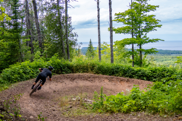
This Trail Network is well known for having some of the best riding in the Midwest. There are 3 full loops that range in legenth from 5 to 7 miles over the rugged terrain. The blue loop (Mt. Marquette loop) is the most challenging with technical climbs and long, sometimes rocky downhills. The Red loop (Pioneer Loop) starts out with a long climb up the Benson Grade across the street, and then descends through the woods on a mixture of single and double track. Look for some amazing free ride trails on the Benson. The Yellow Loop (Carp river loop) starts out mellow with a good downhill section and then climbs up Marquette Mountain Ski hill. The descent rewards you for the challenging uphill with a great run down "Easy Rider" These Trails are managed by the Noquemonon Trail Network. Big ups to them for all of thier work.
 | Baby Blue | 0.3 mi | |
| Bertha | 0.3 mi | |
| Chunder Muffin | 0.3 mi | |
| Doctors | 0.8 mi | |
| Down Dogger | 1.1 mi | |
| Flow | 0.7 mi | |
| Forget Me Not | 0.2 mi | |
| Gorge-ous | 1.6 mi | |
| Gurly | 0.1 mi | |
| Hardtail Pride | 0.6 mi | |
| Jaw Bone | 1.2 mi | |
 | Marquette SBR (snow bike route) North plus South | 25 mi | |
| No-Dab | 1 mi | |
| Off Grade | 1.6 mi | |
| Pipe Dreams | 0.4 mi | |
| Rooster | 0.2 mi | |
| Smiley | 1 mi |


 7
7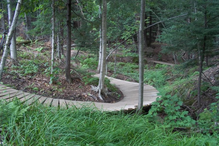

Wonderful chunder, absolutely worth the trip.
| ThankThe signage on this trail system is beyond terrible. It needs to be better marked. The yellow trail especially.
| ThankLarge scale gas line construction project altering the trail system. Leaving portions of the system that has been iin the past easy to moderate closed. Found section wet, Muddy, from recent rains. Good deal of the difficult was just that!! Lots of roots , off camber rocks, all fine for expert level riders. Will wait for next year when construction is complete.
| ThankAmazing trail network..plan your ride or just start riding and find your way back (trailforks helpful). Drains water well so even after a lot of rain the previous day, was tacky and perfect (with very few wet spots). This area has a little of everything from green loops to double black jump lines (not on the map, but marked appropriately on the trails). Sports Rack in Marquette has some great bikes for rent/demo and very helpful so recommend. Lots of parking options, tools available and even nice shady picnic tables and changing rooms at the main trailhead.....overall just amazing.
| ThankBlown away by these trails. They have everything you could ask for. Mirror creek is pretty easy and so scenic. Can't wait to come back
| ThankWOW! Such good trails tucked away in some of the Midwest's best topography. This place really has a trail for everyone. Gorge-ous contains stretches of idyllic, exposed singletrack. Those looking for more of a technical challenge should try the brutal tracks Southern Cross, No Dab, and Flow. Lastly, pristine flow trail can be enjoyed on Down Dogger, the Dual Slalom Course, or Eh Line. Whatever you choose, not a single trail will disappoint!
| ThankGreat trails...very scenic and challenging. Definitely worth the trip
| ThankI'm been lucky enough to ride in most every state of this great country and have experienced many great trails. Marquette stands up in terms of variety length and most of all fun riding. It's not real close to anywhere but worth the trip
| ThankAbsolutely phenomenal riding here, there's so many trails throughout this entire system that it'd be near impossible to list. Everything from gnarly technical downhill runs to huge tabletops, some crazy big drops, and everything in between. Ride here asap.
| ThankI rode the majority of the south trails over two rides. I have to give them a great rating although I would really prefer to have a single track climb instead of the road up Benson's. The south network offers trails of varying technical difficulty so it makes no sense to rate it. Suffice it to say there are sections that will challenge most rider skill levels.
| ThankWonderful trail system, lots of fun trails for the whole family.
| ThankThese are really really really great trails. Rode the pioneer loop for the first time. The first stretch was a little more technical than I needed, but the rest was awesome. Flowy and fun and incredibly scenic.
| ThankExcellent trail, well maintained and beautiful views
| ThankBest trail system I have ever ridden. so much to do and see. EH line and Down Dogger are an endless amount of fun.
| ThankEndless, Scenic awesomeness.
| ThankGreat trail, very close to Copper Harbor in quality
This is for the Freeride side of the mountain only. Lots of fun to be had here. Didn't have a lot of time but the jump trail was so much fun and well thought out. The trail Flow was more gnar then flow. Your Mom was a great challenge and ride. I rode a few others and had a great time. Can't wait to come back and explore more!
| ThankAmazing. Can go from bone rattling, to rock dancing, to root ladders, to sweepy flowy berm riding; all in the same ride. Definitely several days worth of riding. Locals told me the winter fat bike was outstanding.
| ThankIncredible system! To plan in advance, the following resources may be helpful:
Excellent map of Benson area downhill tracks that is also posted at the trailhead: http://marquettetownship.org/download/recreation_committee/recreation_maps/Benson_Area_2015_Final_11by17_Low_Res.pdf
Good video footage of most trails: http://trailgenius.com/trail-genius-map/south-trails-marquette-mi
...in addition to mtbproject.com if you like.
| ThankRode the green loop. Fun trail. Pretty tough and technical for maybe the first mile or so for a newbie like me. Trail went up,up,up with lots of rocks. After the initial tough part the trail smoothed out. An occasional root and short stout climbs were the norm. About half way through you will be treated to some river rapids and a waterfall. Very scenic ride. Almost crashed a couple of times because the scenery was incredible. Oh, also there are a couple of places were you have a nice straight, smooth downhill where you can really fly. My only complaint, and perhaps I am displaying my naivete, traffic was allowed in both directions.
| ThankRode this weekend. Rode NC last year (DuPont and Kerr Scott/Warrior Creek). This trail system far surpasses Warrior Creek.
| Thank