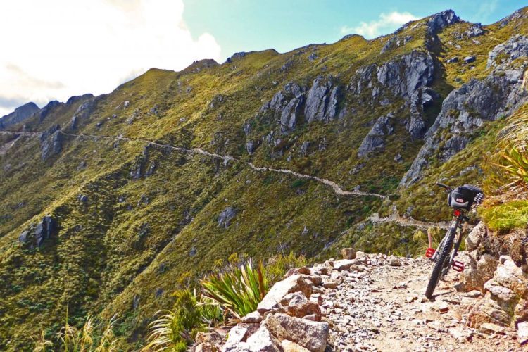
This trail is considered by many to be the premier cross-country ride in New Mexico, and for good reason, it offers 22 miles of sweet downhill singletrack cruising thru deep and dark evergreen forest, aspen glades, meadows; providing great views and some technical challenges at the end to give you a dose of adrenaline to finish the ride. It doesnít get much better than this.
First off, unless you are riding with someone that knows the current route, I strongly advise that you go to a Taos bike shop (there are lots) and get a current map of the trail. The 1996 Trails Illustrated map is missing a lot of detail and does not show the current route, so donít waste your money.
You start the ride at the trailhead on the east side of Osha Mountain, near Angel Fire, at about 9,900 feet. From there it is about a mile and a half of sometimes rocky uphill grind till you crest out at 10,770 feet. The trail then goes downhill on an open, rocky road ride for about the first mile, and then you enter the real singletrack. Enjoy the sweet, winding, singletrack thru the forest, past Quintana Pass, where you will pick up doubletrack and continue till you get to Garcia Park (Forest Road 437). At this point things get tricky for a couple reasons: 1) you have a lot of intersections over a few miles to contend with till you get back on true singletrack, and 2) the trail has been rerouted so the directions you may get from friends or outdated trail maps/guides will conflict with the current route. Compound that with the funny-boys who think it is great sport to steal or destroy trail signs and you have the potential for a lot of wandering. Most of the trail is well marked, but donít count on it. IMPORTANT: When you get to 437 the old directions said to go right till you crossed a cattle guard; that is no more, YOU NEED TO GO LEFT, downhill to the south, and continue on the road for about a quarter mile where you should see a trail perpendicular to the road on the right, heading west across the meadow and into the trees. From there the route is too complicated to try to explain. Hopefully you will find the ì164î that someone has managed to carve or mark into signs, trees, etc., that guide you thru this section of the trail; look for green treated poles, too. You will be riding doubletrack sections, singletrack sections, bits of road, etc., till finally you get to the cutoff for Don Fernando; at that point you are back onto singletrack for the remainder of the trail and the route finding is relatively easy and low-risk. You then have many more miles of cruising thru the forest to the final downhill section. The last few miles present some technical challenges, like steep sections, which are sometimes rutted and/or covered with loose rock, or some interesting rock obstacles. Blast on thru if you have the skills, or get off and walk if you donít want to take the risk. In any case, if you are worn down when you get here it would be wise to take a break so that you are alert and ready to respond to the challenges ñ you donít want to end a great day with a serious injury.
If you can schedule it, I recommend doing this ride during the last couple weeks of September. You will be rewarded with cool temperatures, miles of golden aspens, and deserted trails.


 2
2

A little of everything….scenic views, narrow ridge lines, stands of pine, and aspen. And then lots of CHUNK! Truly an Epic ride.
| ThankShuttle Taos provides dependable daily shuttles to the South Boundary Trail: shuttletaos.com . Formerly Turquoise Tours, Shuttle Taos and our crew have been serving, riding, and maintaining the South Boundary trail for almost a decade.
| ThankI finally got the chance to ride the SBT. Great ride! This is truly a premier cross-country ride, and the end (the last 5 plus miles) is a hoot. There is a very nice long high-speed downhill section after Paradise Park in the middle of the ride. The Heaven on Earth section after the first climb is a nice long downhill too. After that killer first climb (~800' in 1.5 miles), climbing is minimal. It's all fun after that.
Also, please believe the reports about the road to the trailhead. FR 76 is a chunky 4WD road after the first mile or so. Do not take a regular car up it. It is a half-hour from pavement to the trailhead. Also, if you have 4WD and want to add some extra four-wheeling to your experience, there are roads that make it up to the top of that first brutal climb. If you have a less-conditioned rider with you, this could be an option you might consider because after that first climb, the ride is an easy 20 miler in terms of exertion. There is only about 800' of climbing after the first climb and ~4400' of joyous descending. Plus, the 800' climbing is quite gradual.
| ThankThe first climb is as soul sucking as a Dementor in the Harry Potter movies. Steep, loose, baby head sized rocks, and absolutely devoid of character- so boring it hurts. After that, it is an absolutely spectacular trail. Beautiful and great trail. If you can not let the first climb ruin your day you will be glad you rode this trail. This is an epic trail, but needs to get rid of miles of steep, loose fire road.
| Thankthe classic NM ride
| ThankOne of my favorite rides of all time! This long trail offers it all. Long peaceful gradual climbs with rewarding descents that are followed by smooth flowing trails through the woods with scenic vies of the valley and mountains. Then there is the pure exciting miles of trails that are just downhill and rocky with so many jumps and opportunities that I about exploded. What a fun trail, I can hardly wait to go again.
| ThankPlease don't take this as a criticism or negative post, but I'm quite sure that you did not see a "brown bear" or better known in the Southwest as the Mexican grizzly. The last known animal in NM was killed around 1930. And the last known Mexican grizzly was killed in Mexico around 1960. The New Mexico black bear has a variety of color phases. So I am guessing that you saw a black bear in a brown or cinnamon phase. If you are strongly think that it was actually a grizzly, you should report this to the Forest Service. This would be a significant sighting of tremendous ecological importance. All that said, kudos to you for riding the SBT. It sounds like a big ride in big remote country. It is definitely on my wish list.
| ThankI'm going to give SBT 5 stars despite the brutally miserable climb at the beginning. "Heaven on Earth" is nice, fast and smooth, and the last few miles to Taos are freaking awesome; fast and technical. If you want to skip the first climb, start at Garcia Park, or on the bypass trail about a mile before Garcia on FR437 (this skips some climbing out of Garcia Park as well).
| ThankThe final descent:
https://www.youtube.com/watch?v=1vOgduprmII
I went in the first week of October. Colors were peak and it was breathtaking. We shuttled to the top and rode to Taos. The last 5 miles went from frustrating rocky downhill and we took the turn off for the "jeep trail" section that turned into a whoops ride of your life. Just a BLAST! you go from high mountains on top to high desert at the bottom. great trail, hit it in the first week of October for the colors.
| ThankThis is a nice epic if done from end to end. Over the course of about 23 miles it will throw a little of everything at you, all at altitude. The best parts are the miles of bench cut through beautiful pine and aspen forests and the dramatic plummets, including the last three very technical miles with very rapid elevation loss. It would easily be worth 5 stars if the full route didn't demand so much climbing on loose rock doubletrack.
| ThankThis trail really fun and offers some great scenery. For great fall colors ride it in October. We rode it both ways and the trail is so flat that it almost seems like you're going downhill in both directions. There are lots of rolling hills and skinny sections to keep things interesting but as usual the rating for the trail is not accurate so if you're looking for a challenging or technical trail this is not the one for you. I would rate this trail as "Easy" due to the fact that it has barely any incline and zero technical sections. However, because the trail does narrow in areas it may not be the best choice for new comers to biking.
| ThankJust rode this trail and it's beautiful right now with all the leaves changing. I swear that this trail is downhill both ways.
| ThankGreat trail! I accessed it from Garcia Park because my Subaru was bottoming out at black lake access. Start of the trail is a lot of traverse and a bit of uphill. Don't let that discourage you, the downhill is worth the wait. This is not a beginner trail. Watch your speed on the corners in the downhill it's a long way down. There are a few washouts but they are all rideable... Have fun!
| ThankA great and strenuous ride, much of it around 10,000 ft. Heed the suggestion to have a good map and directions. Very easy to get lost! One of the coolest things about the trail is that it is minimally maintained and is not like your heavily used, well signed trails you might be used to. It is a wilderness experience. If you ride it alone, just remember that a mountain cat will make a hissing sound before he jumps you from behind.
| ThankGreat epic ride! I would advise going east-to-west, however, and forget the steep dive down to El Nogal Picnic Area at the end. The Ojitos trail is a great way to end this ride, with miles of whoop-de-dos before ending up in the outskirts of Taos. One other thing. In the early part of the season (May, early June), there can be a lot of snow and deadfalls. Later in the season the snow is gone and the deadfalls should be removed.
| ThankThis trail is as advertised. I never get sick of reading articles in magazines about this ride. Epic singletrack, epic DH, epic trail all together. Great trail in the fall with all the aspens in the area.
| Thank