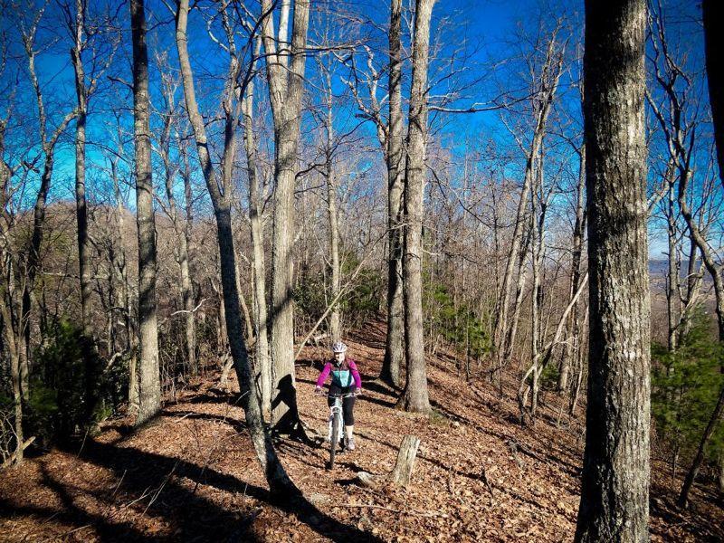
Mountain top riding at it's best. Just 1 mile off Interstate 77, this short but tough trail is a good way to stretch those legs.
Trail can be ridden as an out and back or loop using the paved road as the return route or starting leg. Trail can be ridden from either Dir. and is easy to follow. From day use area; cross creek and take first trail to the right through the Mountain Laural tunnel. For the next mile follow the single track up the old logging rd. grade to the top of the ridge, At top of ridge take the trail to the right (tr. to the left is an easy ride out to a bench where it dead ends, good choice for those wanting an easier ride).The next couple of miles is mountain top single-track with a few short but very steep climbs. Shortly after passing
the highest point ( sign;3310') trail will traverse a very steep side slope, feel free to walk this section. Past this make friends with you brake levers, 2 miles of downhill bliss. First switchback is unrideable???, 2nd easier, then 2 small gully's, then you can let go of the brakes, just be mind-full that you are approaching the campground nature trail, and possibly small children. At the Y go L or R to the campground, and either ride the road back, or better yet refuel and head back the way you came.
If you do as an out and back be shure to add in the short but, sweet trail on top of the ridge. (very enjoyable and it'll give you a solid 2 mile downhill back to the TH). Don't let the shortness of this trail fool you It's an hour ride each way. Also if on a weekday you will probably be the only one there.


| ThankBeing summer the trail is some what over grown but the down is still fun
| ThankInitial uphill is about a mile long but not technical at all. Once at the crest, a series of short up and downs keep you on your toes. Some of the ups are quite steep but short in length. The start of the downhill is marked by a sign indicating you've reached the highest point on the trail. The downhill is fast and lots of fun. Several areas are exposed on steep side hills, so quite the pucker factor. I was excited to ride both switchbacks.
| ThankGreat trail overall. Not overly technical and a great workout.
Above my skill level. Entered at Stony Fork campground and in second mile found I could hardly stay on the trail -- I kept sliding off the downhill side. Once I hit the high point the downhill to the trailhead was awesome, but I guess this trail was above my bike mechanic's skill level too because the new chain he put on kept rolling up between the front chain rings and the frame. At EXACTLY halfway in, I twisted the links when that happened, which made the drive train inoperable. I had no way to pedal. I walked up and rode down. Tough outing, but it is a lovely trail for those who can really ride.
| ThankSeven Sisters is more of a hiking trail than a Mt. biking trail.Several hills are just too steep with loose rocks and narrow off camber hillsides.Even the toughest bikers will find it challenging.It is not all bad.When there is a good stretch of trail it worth the hills.Great views from the ridges and nice sections of down hills.If they could add some switchbacks and bench cuts it would be more rider friendly.
| ThankI rode this trail for the first time today. The description given is inline with what you will find. I only had to dismount my bike for the one switch back because it was almost a 300 degree turn. The thing about this trail is you don't ride it, YOU CLIMB IT!!!!! Down hill was fun but short, not sure the climb was worth the downhill. What makes this trail tough is the extreme climbs where you can't spin out or you are done besides that nothing else should bite you. If you like a challenge and love to climb then this is the trail for you.
| ThankGlad 7 sisters has no brothers rode it 8/6/11 trail is in good shape but the 7 100 yrd climbs at a 35% angle how do you ride up that? i ride intermediate trails i see why its rated black diamond. Still i enjoyed it but had to walk bike up the 7 peaks
| ThankI have been coming through the area for several years usually right before dark and can never complete the trail. I finally got to ride the whole thing yesterday. It was great. The short climbs are a challenge and the narrow downhill on the back end keeps you puckered. It is well maintained and is one of the coolest short trails I've ridden. Thanks to the locals! Now put one over Big Walker!
| ThankThis trail gives you a good work out ,no manner how gooda shape your in.It is well kept by local mtbs .Parking avaible at either end,easiest from day parking to campground with a couple steep push/climbs then sweeeet payoff.Others do an out and back from campground.The addition from the bench out toward I77 is almost finished/cleaned out and should not be missed.(again this is the left after you climb from day parking,about 1 mile up ) The NAT GEO map # 787 covers this area.
| ThankJust wanted to add; the trail has a rock, shale, gravel base, so unless it's thunderstorming, rain is not an issue. Adding appx. 1 mike of trail past the bench. Still a out and back, somebody put a interstate highway through the middle of the mtn.* Review edited 3/13/2011
| Thank