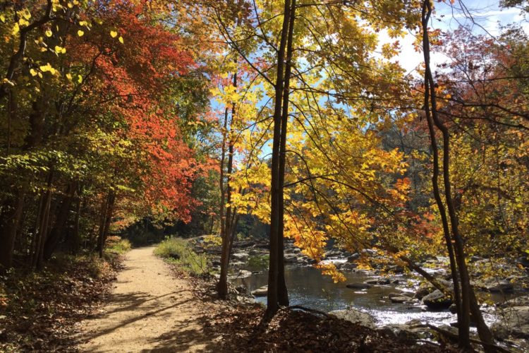
The main trail is a gravel trail and is very easy. There are many single track trails off of the main trail. But beside the main trail entrance is an up-hill climb which is laden with large roots and babyhea**mall, sharp, loose rocks), presenting a precursor to this trail's condition. This immediate up-hill will bring you to the singletrack trail network, which split off many times from each other, creating many different combinations. If you begin taking consistent right turns when the trail splits you should be able to follow the railroad tracks. If done correctly, the trail overlooks the train tacks. But what ever trail you end up taking, you will encounter many large roots, up-hills and down hills, baby heads, a river crossing(depending on which trails you take), Log jumps, mud, and many other combinations. This is a very challenging trial due to its quick downhill/ uphill change, requring quick gear changes and an eye for a good line. The trail ends at the top of the Lake Accotink dam. Just follow the Asphalt path down to the information center. At Lake Accotink there are water fountains, boat rentals, and drink machines. If you continue past the beach to the bridge, you will follow a gravel trail which ends at the Wakefield ball fields. Continue on to the rec center and then onto the Wakefield trail network. To return to your parked car, take the asphalt trail back up past the Lake Accotink dam and then onto the gravel trail. This trail will quickly take you back to the trailhead.


 2
2
Pleasantly surprised. Has a wide multipurpose trail that comes down from Wakefield and crosses the stream by bridge and then downstream over the dam and circles back to make a ring (cross county trail and Lake Accotink Trail. But skip that. When coming from Wakefield make the first right that crosses the stream by bridge, follow the paved trail up a short steep hill to end up in neighborhood. Pedal up Danbury Forest Drive until it ends and go straight into woods and up short burner. At top skip the big fire road like trail (Lake Accotink Trail) and take the single track with the sign that says that it's maintained by the boyscouts. Just a whole bunch of interlocking trails that make good use of the topography. Just ride em and have fun. This part is definitely moderate difficulty for quick elevation changes, some short fast downs, stream crossings and roots galore with the odd downed tree to pedal over. Just saw the trails on the map and decided to take a look because Wakefield was too muddy and The Garry Connolly Cross County Trail and Lake Accotink Trail are boring as you know what and I was pleasantly surprised. Nothing gnarly but quite fun. I need to get back here and explore more of em. And gotta talk to MORE- if they had some manmade drops in here this place would be awesome.
| Thank"Hello,
"Community Input Needed on Future of Lake Accotink
The future of Lake Accotink, including whether it will continue to exist at all, is on the front burner. There has been some discussion within the Fairfax County Park Authority of tearing down the dam and eliminating the lake. I believe Lake Accotink is a community asset worth saving, but the issue is complicated and community input now is critical."
Please spread the word!
Here is the link to Braddock Supervisor John Cook's newsletter that lays out the situation, including the statement:
The Park Authority outlined these options at its January 22, 2018 meeting. Some attendees to the meeting came away with the impression that the Park Authority favored getting rid of the lake.
Will you help?
Thank you,
Wade Corder
Neighbor of Lake Accotink
http://files.constantcontact.com/71c12914101/fb2ed546-e17e-4876-96b3-1c23c20c0656.pdf
| ThankLake Accotink has two kinds of trails: The fire road and paved loop that goes around the lake, and the hidden MTB trails hiding in the West corner along the railroad tracks. This makes Lake Accotink ideal for beginners and experts by providing numerous trail type options. Recent improvements to the MTB trails have made the singletrack riding more enjoyable, and reduces the disappointment of all the paving they have done to the North side of the lake. All in all, Lake Accotink is a good technical ride, interval ride, or just a good cool down after riding Wakefield.
| ThankThe trails here at Accotink are a little more rooty and rocky than at Wakefield, but if you are into that then you are in luck! The whole point of Accotink is to get a little lost and explore rather than always staying on the main gravel path. There are a lot of little features in the system that are actually pretty technical if you are going fast. I HIGHLY recommend starting on the far side of the park (towards this railroad chemical tank center thing) rather than at the top of the dam. By starting at the far side, the trail will be slightly more downhill primary going towards the marina overall.
In terms of trail conditions: With heavy rain, its best to wait 3 days for the trail to dry, but the trail is rideable after only 2 days if the humidity is low. Vegetation is a double edged sword: The trails are very shaded, so you can stay cool-ish with temperatures in upper 80's with humidity. However in many areas of the trail, it is pretty common to have your legs being slapped by poison ivy and other thorny vines - which is very annoying especially when you pick a line where getting hit by poison ivy is unavoidable.
Overall, the Lake Accotink area is like the Yang to Wakefield's Yin. It feels more raw and technical than Wakefield, and there are a lot less people and events at Accotink than at Wakefield. As a more Intermediate/Advanced rider myself, I kinda feel like Wakefield is more of a warm up area for me, whereas Accotink is a place where I go to grow my skills. Soo, yeah. That's just my two cents. :P
| ThankNice trail system. Main part is gravel, but there is some nice single track.
| ThankThis is a scenic ride great for beginners around the lake. There are some trails that jut off to the side that are fun to ride too.
| ThankGreat up and downs - serene alongside the railroad track. More technical than Wakefield but the two routes in one morning makes for some solid MTB'ing very close to NW DC, NOVA.
| ThankNear Wakefield this a great trail with a variety of trails and some serious climbs and downhill!!!!
| ThankAccotink is Maad fun!, Some moderate and technical climbs, fun descents. The trails are pretty much a bunch of extending figure eights going along several ridge lines and valleys. Nothing hardcore. There is a lot of trail around there and you could even catch a fire road to or from Wakefield park. There is also a DH jump line section. But if ya don't know ya don't know ;)
| ThankThese trails are fun with a lot of variety. Towards the west end of the network, there are some doubletracks that can provide some high speed or simply a route out to the main trail.
| ThankCombine a meandering loop through Accotink with a loop through Wakefield park to the north for two or three hours of riding.
The trails are currently in excellent condition. No puddles or trail blockages.
Few puddles...made it fun. Great trail.
| ThankI would love to live in one of those neighborhoods with those spurs. I do think the signage should be a little better on the rail trail because I accidently ended up at wakefield.
| ThankRode in from Wakefield. Nice scenery, and plenty of trail. A few techy spots that shoot off main trail. Will be back more to explore.
| ThankThe hills in the trail are pretty intense. Lots of fun. However, the trail itself is pretty confusing. Everytime I was able to get on the singletrack from the main gravel path, I would end up getting spit out again. I couldn't quite figure out how to stay on the singletrack. It was great riding, lots of roots and quick decents and some stream crossings. Just be prepared to do a lot of navigating.
| ThankIf you happen to be riding this trail, we are missing an tan Italian Greyhound in the area. Call us @571-423-9058 if you spot him with the best information you can give us. thanks!
| ThankJust started riding this trail a couple of weeks ago and its the closet to my house and then Wakefield. It was very fun just to new to the trail so i don't know all the routes in there yet but soon i will.
| ThankIts pretty good and what all the people said on here are spot on about this trail. the back trails could use some work in areas, but for a trail that's in the middle of suburbia its good enough. It has many places that you could push your self. Tire choice would be a little less knobby then wake field. because i feel that there is less sand.* Review edited 9/10/2011
| ThankGreat lunch break trail if you live/work in Springfield. Not marked or mapped very well so I managed to get lost. Had I not been on a time limit, I could have explored more. I only did 3 miles and didn't find anything too extreme but it was fun.
| ThankEnded up on this trail after starting on Wakefield trail system. After coming around the dam I ended up on the more technical section of the trail and had a blast. There is plenty of hills with sharp turns and I would have explored more if I hadn't snapped my chain.
| ThankThis trail is fun, but confusing--easy to get turned and twisted around. Ride with Wakefield for a great couple of hours.
| Thank