Like South Mountain, this trail overlooks the city and every view is spectacular. Looking to the west, the vast city of Phoenix and to the East the beautiful McDowell Mountains. To the North you see Red Mountain and the Salt River. Since the trail is almost all down hill, be sure to stop and look at what you are riding in. The beauty of Arizona is at its peak. Since the trail is primarily down hill on loose disintegrating granite, make sure your brake pads are in good condition, you will use them a lot. After the 5 mile trail ride, which ends on Power Rd, simply ride the road back to the car parked at the shopping center. If you consider yourself a skilled rider and would like a challenge, ride Hawes in the reverse order as described above. You will have to be a good rider in strong physical condition to master the trail ahead. An intermediate to skilled rider should allow 1 to 1.5 hours to complete. Take plenty of water and an extra tube. The desertscape can cause a flat in no time.
 | Ridge Trail | 2 mi | |
| The Saddle | 1 mi |


 8
8

The popular parking seems to be behind the Walgreens, from there cross Power Rd on Eagle Crest Dr. After going over a bridge the trailhead is on your left. From there it winds through classic AZ desert hugging the housing development. There are a few trail off shoots that I was able to link together to make a decent 9 mile loop. Lots of challenging climbs/ descents. As usual it is very picturesque. Trail is relatively popular so expect to meet with a lot of other riders. The trail section closest to the houses also have a number of walkers on them. Would like to come back and explore deeper into the system. My only complaint is that it could use a little more markings. Maybe I just need to do more research prior to a ride.
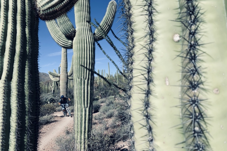
| ThankClassic Sonoran Desert views. Great trail to bring out of towners that have never been to Arizona.
| ThankNice place with considerable climbs and descents in the cactus covered hills. Not gentle climbs.
| ThankFlowy and fun.
| ThankA little short but a really good time. A good challenge. Fun rocky tech (not too gnarly) with some challenging short ups and downs.
| ThankHere's the best map I could find online. It's quite helpful if you are new to the system. http://globalbikes.info/merchant/1079/images/site/Hawes.jpg
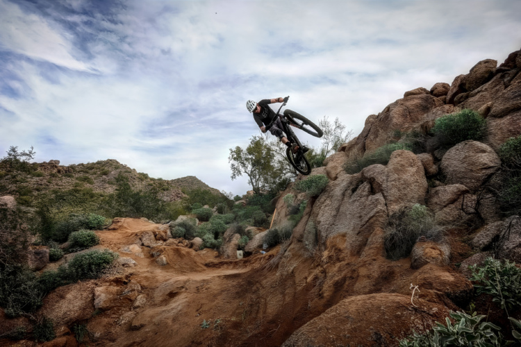
| ThankLots of fun to be had here. Most of the trails are narrow singletrack though much of the Hawes Trail itself is more of a double wide. Below Saddle there is lots of flow; lots a little tech, and some good intermediate tech all in and out of washes and up on little ridges. All the intersections below Saddle are well-signed. Above Saddle, the Hawes Trail becomes poorly marked. Be careful, and for the most part stay relatively close to the housing development if you want to stay on Hawes. It also becomes more technical (in a good way) the further up you go, including the trails up around the Tower Trail and Hawes Loop Trail itself. The trail is definitely advanced up in these sections. I really enjoyed coming down these upper trails.
| ThankAbsolute pleasure. Can't wait to ride here again. Good work climbing CC and super fun fast flow clockwise. Might be the most fun I've had on a mountain bike, even though I am new at it. There is a pretty challenging downhill section off of the tower road access. Road some and walked the most difficult.
| ThankSuperb ride up to the mines. If you enjoy rocky/technical single track, this is s super fun ride. There are a ton of routes that can be easier but the area is like Disneyland for mountain bikers.
| ThankMy go to for a short ride near Mesa AZ, The Hawes Loop counter clockwise segment (see Stava) is about 9.6 miles and 1300 plus feet of climbing and I have a blast on my single speed. Being new to the desert I had to learn how to corner when the sand got a bit deep. Side knobs on the front tire are very important. The steep loose stuff puts your traction skills to the test. There isn't much tech, but there is some. Going Clockwise I have to walk a few short sections. There are a few other trails so you can alter the ride for some variety and some out and back trails that go out to THs on Power Rd and over to Usery park. So lots of options, but you may end up doing some trails in both directions or some twice, depending on the route and distance you are going for
| ThankThis is a fun spider web of trails. This is more XC orientated than South Mountain and you can create new routes on every ride. You can ride all day here, or make for small loops. This is a fun place for lots of friends as it is not very technically demanding. There are a few sections that require skill but for the most part all users can ride here.
| ThankWe (my friends and I) are beginners, alternating between 1990's fully rigid mtbs and intro- Front Suspensions (Trek & Montague). LOTS OF FUN!
| ThankAwesome fun trail with technical spots. Beautiful ride all around with a great view of the salt river. Being water and a helmet
| ThankVisiting the area and first time here. Really nice trail, much less rocky than most in the Phoenix area. A little bit of everything, some flowy XC, decent climbs and cpl short DH spots. Great views. Lots of trails within the network to chg things up. Will definitely come back when next in Phoenix
| ThankThis is one of the best trails in phoenix. It has a lot of features to offer from some fast rolling parts to challenging climbs to tight corners and one or two technical spots. However, the big rain/flood that just happened a few months ago have really made this trail very sandy and washed out in a few spots. But with that being said, it's still one of the better trails in Phoenix. I always start at the trailhead off bush highway right next to the canal crossing. I ride counter-clockwise taking hawes rd to saddle and then taking that to saguaro and finishing with ridge trail. It's a great ride and beautiful desert scenery.
| ThankToday was my first time riding these trails. I rode in from Thomas/Power Roads. Once I came to the trails I started riding up Hawes (a local said it was cardiac hill) and quickly learned I was out of my league with the steep incline. I came back down the hill and rode saguaro, which became narrow and steep. I had to walk several sections before navigating back down. I think the intermediate rating for this area is way off. It is for the expert rider.
| ThankFast, fun, flowy connector of Hawes & Saguaro Trails with Ridge Trail in the middle.
| ThankRidge trail is great. Access it from either side of the the Hawes Tr #52. I prefer access from the Las Sendas are as opposed to far up the Bush Highway. You can either park at Thomas & Power behind Walgreens with all the other bikers and start and the beginning of las sendas & get ready to climb or park at Power & McDowell and go up Hawes Road to N. Diamond Point Rd. The trail accesses behind the last of 3 houses on the left. Otherwise the TH at the Hawes /E Teton intersection makes you hike-a-bike to the top, which is NO bueno. Here is the map of the whole system..https://maps.google.com/maps/ms?hl=en&ie=UTF8&oe=UTF8&num=200&t=p&msa=0&msid=103656266278992251523.0004661b537b86460603c&ll=33.504115,-111.66461&spn=0.04652,0.051498&z=14&source=embedI Once you get to the saddle, #51, take that N (looking straight at red mountain) and head Left at the sign post. THen head L at either trail at the T junctions up ahead. They both meet up at the bottom so there are 2 ways down the Ridge trail. Just make sure you turn L if you run into the Saguaro Trail if you go to the 2nd T junction. Be careful around the red rock incline and take either the Bush HWY or the Hawes #52 back to the Power/Thomas entrance. One of my favorite loops. Hawes is the shit.
| ThankDidn't know what I was getting into!
| ThankHad my first ride in these trails yesterday, and cannot wait to get back there. What i like the most is the combination of good climbing and fast and challenging descending.
| Thank