Start up the road. At 0.2 miles, you have your first decision point--you may turn left up the road (this the long way, but it takes you up untravelled road then gives you extra singletrack which will dump you out back on the main road a few miles up) or go straigt up the road and hed for the entrance to the ridge. Either way, you will come to a fork with a bunch of mailboxes in the middle--go right. A little over a hlf mile thereafter, you will see the Mt Helena ridge trail on the right. The climb is moderate at first and steepens for a bit before you gain the ridge--then the fun begins. There will be some roller-coaster downhill, popping in and out between meadows and ofrests. The singletrack is excellent. After 2.6 miles of singletrack, the mini ridge trail heads down to the right--ignore it. After 4.0 miles of singletrack, the Show Me The Horse trail (unsigned when I last rode) heads to the right. Look for it as it drops to the right in an open area--this is the best descent. Or you can go straight another mile an a half to complete the ridge and take the McKelvey trail (this is the one that dumps out right where you parked). The Show Me the Horse trail meanders gently downhill through the meadow at first, then picks up speed as it enters very thick forest--it yanks and banks at high speed with some bermed corners and a couple small drops that are an absolute hoot. After a mile and a half of rip-snortin' good fun, even hitting the pavement wont wipe the grin off your face. Follow the road a short distance back to your car.


 19
19

Catch the free shuttle bus out of Helena. It doesn't take you to the top of the hill but it does take care of most of the gravel road. The singletrack that climbs to the top of the ridge is a masterpiece - perfectly controlled gradient most of the way up as you gain over 2000 feet - so you won't burn your gluteus maximus if you take your time!
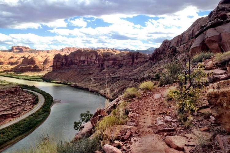
The track along the ridge mostly slopes down gradually- there are just a couple of small undulations. The trail is old-school cross-country style, devoid of significant technical features. (The photos of rock drops are actually off trail!) You can get up a bit of speed in places which is exhilarating. The views are nice but not breathtaking.
All up, if you take the shuttle you'll ride about 10 miles back to town. That should leave you feeling satisfied but probably won't give you a sense of achievement.
The Mount Helena Ride Trail is a good ride but not outstanding.
| ThankAmazing trail with views you only see in magazines. A must ride if you find yourself in Helena!
| ThankThis trail is a great piece of singletrack. The climb in the beginning is big enough to warm you up, but small enough to avoid being seemingly endless. The fast ridge riding that follows is beautiful and has excellent flow. Since there are plenty of options when dropping off the ridge, you can chose whatever type of descent you prefer. It's a mountain biking buffet!
| Thank5 out of 5 stars! This trail is a fantastic climb, complete with a bit of everything: climbing, fast descending, chunder, and more. This is a must-do if you're in Helena!
| ThankWow, what a great trail. Mt Helena Ridge is just one of many in the trail system just outside of Helena. It starts out with a decent climb to the ridgeline with awesome views. I took skibum's advice and followed Show Me the Horse trail down to the road, a very fun descent!
| ThankThis ride is a real dandy. There area a number of loop options, each beginning with a nice climb, great ridge riding in the middile, and finishing with a fun downhill. This ride packs in a lot of variety for its length and is easily accessible from town. Definitely do this if you're in the area!
| ThankI was just passing through and thought I'd jump on this trail to pass the a.m. I was very surprised this beauty sits so close to town. I rode up Dump Gulch(?) and took the ridge trail back to it's trailhead. Good incline to start, I enjoyed the thigh burner ups, and cruiser downs, some good trees and meadows, excellent views- all in great shape! Killer!
| ThankSteddy climb with a single track climb option via Wakina Sky. Absoulety execellent variety. Rolling meadows, nasty switback mountian climbing, rolling buffed decents, decomposed granite
| Thank