All trails begin at the Trailhead Parking Lot on the east side of Gambrill Park Road (about half-way up the mountain between the Rock Run area and the High Knob area, on the right side of the road). All trails are day use only ñ there is no overnight parking. Park hours are 8 a.m. to sunset, April to October, and 10 a.m. to sunset, November to March. All Maryland State Forests and Parks are trash free. Please carry out what you carry in.
All trails, except the Catoctin Trail, are loop trails, and return to the Trailhead Lot. All trails, except the White Oak Trail, are open for hiking, mountain biking, and horseback riding. Please respect other trail users.


 7
7
Lots of rocks, steep climbs
| ThankCheck out my review on Youtube at DADventureTV.
| ThankGreat place to go when everything else in the DC area is too wet to ride. Lots of rocks, very little dirt. Technical but no big features. Not very flowy, but fun! Trails are fairly well marked. This is a review of the 7.5 mile yellow loop.
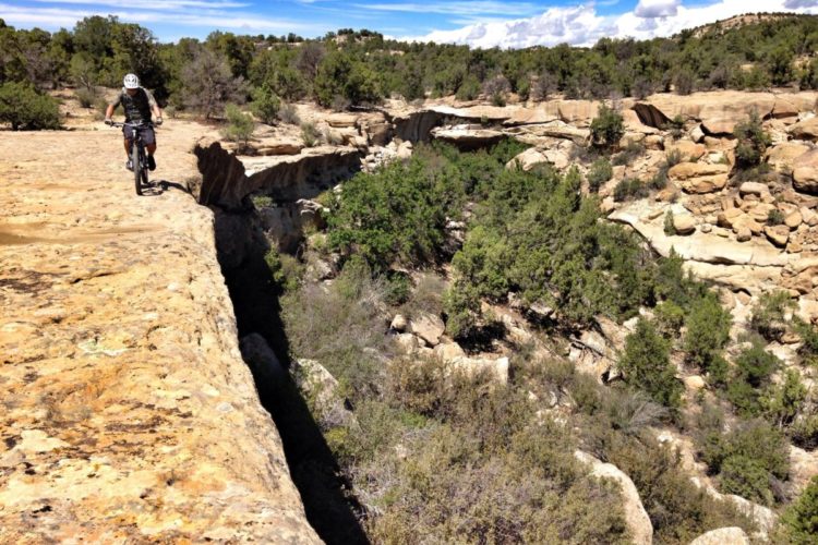
| ThankDid 20 miles yesterday in the fog and rain. Very demanding but beautiful. The trails are rocky but you can all downhill and many uphill. Be very careful when wet the rocks and especially the logs are very slick especially near (and in) the streams - falls come hard and fast. Great workout for your entire body!
| ThankTrails are very well marked and not for the faint of heart. The yellow loop was awesome ridden Clockwise but looks to be fun both ways. The black trail is definitely more DH clockwise. Counter cw is mostly very technical climbing. Amazing DH from the overlook at the road on black.
| ThankTried this for the first time and rode the whole yellow trail and some of black. It was fun, but some of it was hard for the sake of hard. Definitely a place to test your (and your bike's) capabilities, but I'd prefer less rocky trails. The trails were covered with leaves which was definitely not ideal, but even with that I had probably half a dozen spots where I had to at least put a foot down if not walk 20 feet. Without the leaves, I think that would have happened only a few times. So if you want to feel challenged, this is a good place, but if you want to go fast with little concern for hurting yourself or your bike, there are better places.
| ThankI do think that if you're considering going from a hardtail to a full suspension, ride this first with your hardtail then you will feel really good about the decision of getting a full squish bike.
Definitely not for the faint-of-heart. I consider myself an intermediate-advanced mountain biker and I would be seriously impressed if someone could ride the black loop without getting off and hiking at any point. I would not rate any of these trails in this park below a moderate in difficulty (and neither does the park). That being said, the yellow loop is a great one to get a little more distance, but all of these trails have some seriously challenging features. All of them have technical climbing and descending involved as well as sharp, jagged rocks protruding from the ground ready to slice and dice those light-weight XC racing tires you're rocking. What's great about these trails is that they're extremely well marked, they offer some great technical challenges, some nice scenic overlooks, and you will get a lot of elevation on your ride if you continuously start onto your next trail from the main parking lot. Note: I tried the black loop in the counterclockwise direction and it seemed as though the clockwise direction would have been the better choice.
| ThankThis trail is very rocky and for that reason i could only get in 4 miles on the Yellow loop.I did ride some of the black and blue trails.Most of it is more suited for hiking.I can see tougher riders liking it.It did end up with about 6 miles,far less than I wanted.All i can handle of this rocks trail.
| ThankPersonally I love these trails yes some parts are so steep you'll be hiking back up but it adds to the experience. I like taking the Blue trail from the lot all the way to the Watershed it drops close to 600 feet in a row at one point and is very technically demanding. Seat dropper post is a great thing to have. Black and Yellow trails are great too and I will always come back for more.
| ThankA friend and I tried out this park. We found that it is great for hikers and bad for those that want to have fun biking. I personally go so I can work out while jumping/sliding/anything fun. On the trail we took (black) you go down on large stones (4 inches in diameter) for a long while. Then you are expected to bike back up up a steep path with logs every 10 feet or so to stop the run off. It was very little fun. If anything take yellow. It seemed to be the least of all evils. It's worth an experience but I could never make it my home park.
| ThankRocky trail very pinchy ride - if you can ride the black in either direction without hiking you will be the first
| ThankThis place is awesome. Tough and technical in spots, not the best place to cut your teeth. Fun riding here for sure.
| ThankGreat technical rocky singletrack. I rode Yellow (including the Upper Yellow Loop which is a the best trail I rode there) then the Green Loop. CCW is definitely the way to go on Yellow as recommended below. Not as technical terrain wise as other stuff in the area but due to being uphill as well as fairly technical it made for a challenging ride. Trails are very nicely laid out with markers making it very difficult to get lost as long as you looked at a map beforehand.
| ThankGave it a 5 because I love that kind of trail, but they are definitely not for everyone. Rock, rock, and more rock, with some sweet flowing ST throw in. Had a blast on the Yellow. Then rode the Black, all except the very strongest riders will do some hike-a-bike on that one.
| ThankRode blue trail from parking lot all the way to Hamburg rd. Long technical downhill sections and very rocky. Will have to hike a bike up many spots. Took road back to park from watershed area and found the yellow trail which is more rideable then blue. Overall fun and challenging but be prepared for lots of rocks.
| ThankHad a great ride on the yellow trail.
Yes there is a lot of rocks, and yes it is technical in certain areas. But, this trail has something that no other trails in Washington DC area has.
It is cooler by 10 degrees comparing to Northern Virginia, and so humid. You even get a cool off wind breath from time to time.
This trailer will improve your riding skills and will beat you up if you are not ready.
I did the Yellow loop counter clockwise.
One more thing, you will immediately learn where your bike weaknesses are.
Yellow trail with upper loop you will have 940 ft of descending and 960 of climbing
| ThankYellow trail without upper loop you will have 620 ft of descending and 640 of climbing
REALLY HARD. I did more walking up and down steep rocky hills than riding. Went here with summer camp. Should have done something easier for my half birthday.
| ThankI was in over my head here. Rocks are my nemesis and this place is full of them. Broken bikes and scars must be a regular occurance at this place. We did ride over to the Shed which had some pretty gnarly downhill runs, also mostly covered in rocks...but very fun.
| ThankIntermediate to advanced intermediate rider. Previous posters pretty much got it right. I'd describe this trail as rocky with occasional single track gardens. Rode the yellow and the yellow extension. Whoever suggested to ride CCW was right on. Very good way to ride it. I only saw the face of God one time... during a descent and tried to get my weight back and mistimed it. Dropped the front wheel about square on a flat sided rock and about went over the bars. That would have sucked. But somehow saved it without destroying the wheel or myself, thank you seatdropper. I would highly recommend if you want to improve your rock skills. I wouldn't recommend a drive for this trail, but if you are in the area it is worth it. Really is weird how I didn't want it to end once it was over. But during the ride I thought about bailing a few times to the road. not horrible technical or steep hills. But when you combine the slow speed and the rocks with the climbs it gets more interesting. Where you could normally keep your speed up to clean a rocky section here the whole thing is pretty rocky so it's hard to keep the speed up for stability.
| ThankAdvanced, rocky trail riding. Full suspension almost a must. Most folks ride the blue trail. Difficult to get any rhythm and a few hike a bike sections.
| Thank