×

|
Rate it:
Tags:
Level: Beginner
Length: 20 mi (32.2 km)
Surface: Singletrack
Configuration: Lariat
Elevation: +212/ -261 ft
Total: 10 riders
Mountain Biking Fonte Da Telha
#7 of 26 mountain bike trails in Portugal
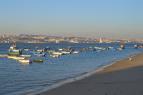
Beautiful up and along the coast with a fairly flat ride until the last loop where there is 200+ foot climb. This is one of the most scenic rides I have ever been on, absolutely beautiful. There is a quick out and back right at the beginning (or end depending how you ride it) that goes down to the beach called Cova Do Vapôr. My suggestion is to ride this late in the afternoon and finish up at the beach for sunset.
Plenty of places to eat and drink after the ride..
First added by on Dec 2, 2009. Last updated Apr 28, 2020. → add an update
Before you go
- Drinking water: unknown
- Lift service: unknown
- Night riding: unknown
- Pump track: unknown
- Restrooms: unknown
- Fat bike grooming: unknown
- E-bikes allowed: unknown
- Fee required: unknown
This trail information is user-generated. Help improve this information by suggesting a correction.
Take Estr IC20 East out of Almada to Av Alfonso de Albuquerque and take a right (north) Follow around the curve and g straight through the round-a-bout to EN5771 and take a right. At the T go left. Park anywhere along the road and the trail head is to the left.