The Burchfield concept is to have two distinct and separate trail systems, one for bikers and one for everyone else.rnThe older trail system runs about 5 miles and is almost all flat doubletrack and generally dull.rnrnThe new system is a bit over 7 miles of both a small bit of doubletrack and very tight singletrack that is a mind-numbing maze as is snakes you up and down a number of ridges and routes you over an unbelievable number of obstacles.
Additional info: Burchfield mountain bike trail is approx. ten miles and fully signed. Look for the orange signposts and don't make any turns until you come to the next one. On the north end of the park (near the main Burchfield Park entrance) there are two options for the Maze, one is rated green and the other blue. Both can be ridden by riding green first and looping back around and heading out on the blue option the second time through. A few sections of the trail are connected by sharing the two track/hiking paths. Please watch for trail runners and other trail users throughout the entire park. The complete trail is comprised of both a few segments of doubletrack, some open meadows, rolling terrain in hardwoods and tight singletrack that is a mind-numbing maze as is snakes you up and down a number of ridges and routes you over the occasional obstacles. The main entrance off Grovenburg Road has restrooms and water during the summer, at McNamara Landing (south entrance off Columbia Road) has handicap accessible water hand pump for fresh water as well as accessible vault toilets. The Riverbend entrance on Nichols road has a portable toilet and does not have water.
 | Beginner/Hiking Trail | 2.4 mi |


 2
2
Nice trails for all skill levels
| ThankLeaves down, but not slippery yet!
| ThankNice casual ride on the blue trail if you just want to get out
| ThankThis is a great, 10ish mile single track loop just south of Lansing. It should be noted (I see it is not in the description) that this trail is closed to ALL bikes in the winter to allow for XC skiing. EVEN FATBIKES. So PLEASE stay off the trails until they are officially open for the season, otherwise we may have to stay off permanently. Local chapters are working to allow fatbikes in the future.
| ThankFavorite Michigan trail! Perfect amount of obstacles and some areas where you can go off into beginner or advanced routes. Very scenic. So fun!!!
| ThankHoly mosqitos - bring your spray cause this place has major clouds of them. Good challenging trail - probly better for locals who can ride it a few times and figure out where everything is. A lot of work has been put into this trail -lots of obstacles.
| ThankI live in Grand Rapids and make my way over to Burchfield about once a year. I always look forward to it. Its good hardpark singletrack.
| ThankI pretty much agree with havlidan. I would add there were quite a number of stunts - more than I've seen at any other trail in Michigan that I've ridden. I also did get turned around more than a few times trying to pick up the trail when it crossed the double track. I think the hardest part about the trail is when it got to close to the pavilions in the park - all those people bbqing on a Saturday afternoon made my mouth water!
| ThankFun place to ride, nothing too challenging. They seemed to do the most with the terrain they were given, which doesn't have many hills. There are some decent stunts here however, which partially makes up for the shortcomings. Overall, great place to ride if you are close but not necessarily a "destination" trail.
| ThankI rode this track not knowing exactly what to expect based on the mixed reviews. I think this trail would be good for beginners and possible intermediates riders but advanced riders would become bored very quickly. There are a number of man made obstacles which should help keep interest in this trail if ridden on a regular basis. Not very much elevation and in places it seemed like the trail was compressed into a very small area just to increase the length of the trail. Overall I found that this trail seemed much wider than it needed to be with foliage removed from near the trail. The green arrows for the "advanced Mountain Bike trail" were two different colors greens (one bright and one more of a forest green that was very good at blending in at the wrong time!). There are a couple of intersections which could have been labelled to avoid confusion but I guessed right everytime so it couldn't have been that bad. Trail was very well maintained.
| ThankLots of different ways to ride at this park. Follow the single track loops and you find some fun obstacles, rock piles, and a few tight technical sections. For a first time mountain biker there is lots of wide flat trails that have some great trips through trees and along the river. It can get a little confusing to find your way around the single track loop, but if you start at the MacNamara landing entrance off of Columbia Highway you will see the entrance to the loop on the right side of the portapotty shed. after the first section follow Dragonball for the rock piles along the river or Serenity for a field ride. Both end up at swamp thing. After swamp thing head left up to Riverbend for more single track. This is a great day trip for a group of friends.
| ThankDrove the hour to this trail because so many people were giving it a 4/5 star review. Man was I disappointed. I'm beginning to think people in Michigan have no clue what a 4 star trail is. 1st the trail markers are little brown blocks of wood painted brown with green arrows, then nailed to trees. You can't see them. Everyone also raved about the obstacles or features of this trail. Most are broken or rotted. There was a sweet feature being build by a very dedicated man in the back section. I rode it my 2nd time threw. That honestly is the highlight of the trail. If you live more than 30 mins away I would not waste your time here unless having nothing better to do. Gave it 2 stars, because the stunt is the back being built is pretty sweet.
| ThankReally fun trail, good technical sections, plenty of bridges, small jumps, logs and rock gardens to keep things interesting. Downhills are interesting but short. Can get pretty muddy on the macknamara end, so watch yourself.
| ThankWas a fun trail once you got to know it. Not very well marked, had to ask directions 3 times. Lots of bridges, tepees, and log rides. You now ride it in reverse and markers are still out there from then and new ones so it can get confusing.
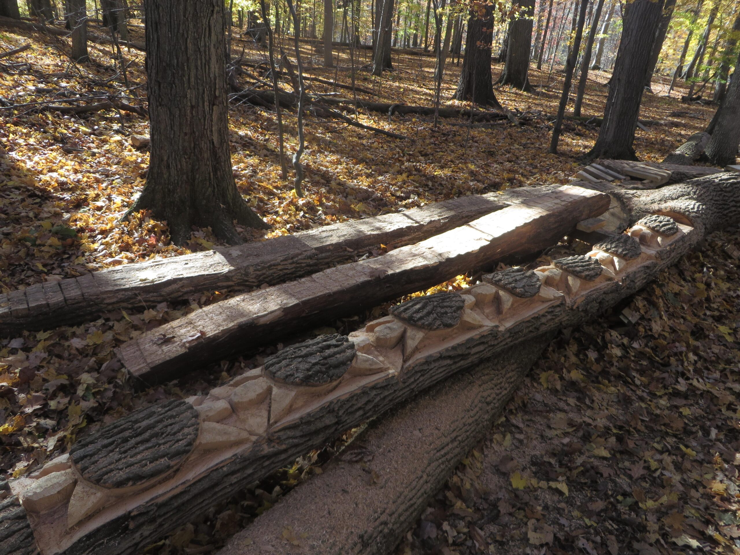
| ThankTrail has a some new sections to allow nearly a complete circuit w/out riding the easy trail. Not all are currently open(wet) at the time of this review, but may be shortly. Randy's Maze/Annie's Playhouse are basically a tight, twisting, very rooted, and somewhat technical labyrinth. Watch for the large rock pile, which can be bypassed. One fun, rocky and rooted descent. Several small ramps, bridges, a log ride, and some off-camber stuff worked in here. Dragonball is a tech gem, with some difficult bridge work and multiple rock gardens. A nice mix of trails. Not much elevation. * Review edited 6/28/2011
| Thankthis used to be a sweet trail till the MMBA changed the lay out and took down all the teeter totter's and made them in to point less docks that take no skill good place to take the kids.
| ThankWe took the advanced trail (there are others as well). Very fun trail with lots of obstacles. However, some of the bridges are getting old. That's what keeps it from being a 5 star trail. Overall, it was lots of fun. It is similar to Fort Custer except for two aspects. First, it has a greater variety of obstacles. Second, it does not have any severe climbs (at least not that we found). There were alot of off-camber portions. Some were so near the river I wondered if I should have brought a life vest. Careful of all the poison ivy. Overall a very good time.* Review edited 5/16/2010
| ThankFirst of all the address is 881 Grovenburg road, Holt Mi 48842. Recent work has been done to the trail (2009) however many of the wooden bridges show signs of age but all passable. This was my first visit here (11/1/2009) and trail was in good shape. Hats of to MMBA mid state for the improvements and or whoever volunteered his/her time. As for the trail it is relatively easy. The trail is mostly flat with only a few minor climbs that are not at all difficult. My fav section was the Dragonballs run as it winds along the river w/several rock gardens and roller coasters over down trees. Trail marking are everywhere. Be cautious in wet weather and late fall as many of the bridges are off camber and can be quite slippery in these conditions. A fun trail overall.
| ThankLove the trail, it's my home-ride as I'm only a couple miles away. It has a great variety of riding... and customizable loops. Beginner's trails, intermediate, and expert riding alike. More technical trails contain ladders, bridges, rock piles, roots, some sand, a few decent climbs and a few nice descents.
| ThankGreat trail! Lots of roots, hills and jumps. The ground is just right for digging in around those trees. Will try and get some pictures to post. OK watch out for the trees broke 3 ribs* Review edited 10/27/2007
| Thank