Tennessee's volunteer spirit shines through in its exceptional mountain bike trails, from Chattanooga's technical Raccoon Mountain to Ocoee's 30-mile Tanasi system.
This was the first true mountain bike trail I ever rode, with a rented mtn bike while on vacation. I caught the bug and ride this anytime I am in the area. There are a few (maybe 500 yds out of 6.8 miles) of technical stuff - rocks and roots - you need to make or you are sliding off the trail. First time I rode I thought I was gonna die - heat & humidity. Just rode it twice while on vacation last week and killed it ... twice. Be aware that this is two-way singletrack so as you come screaming around a blind corner you may make a new mtb biking friend that is screaming around the same corner from the opposite direction. From trailhead runs 6.8 miles to Boyd Gap Overlook and then on the same end of the parking lot but on the other side you can take Boyd Gap trail which is high-speed, rocky downhill, then up the raft put-in road back to Boyd Gap and back to the trailhead ... about 15 miles. Fun, flowy and tight but lots of fun!!! Will ride this every time I'm in the area. In fact, as we left to come back to TX, I stopped at the trailhead and walked down 50 feet or so just as a remembrance of the fun.
My favorite trail ever. Fun, relaxing, beautiful. Fast and flowy. Views of the river, wildlife spottings, zooming through the forest. It doesn't get better!
This is my kind of trail. Pure fun and flowing. Seven miles one way and then back. You can get good speed both ways. Shady, well kept, some scenery. elevation 684 ft. Sept 5, 2017.
i loved this trail, My son and i were staying at Mulberry Gap in Eljay GA we drove over for the day to ride and make our yearly white water reservations,. the only thing i would warn anyone of is the poison ivy :( it ate me up i 'm staring week two of it argggg. but love the ride
I am getting a bit philosophical here, but this trail really made me think "what is it I look for in a trail?" There is nothing particularly technical about this trail, nor anything that makes you think you might face imminent injury. But I get super-hyper technical at home in Markham, FL, and I can face all the imminent injury I can handle at Santos, FL.
Epic, well known trails like Pisgah- where I have also ridden can do both those things, and are, I guess epic partially for that reason. And I love Pisgah. A place like Pisgah represents a massive challenge, and sometimes that's what I want in a ride and a trail.
But THIS trail was some of the most fun I have had on a mountain bike. I have ridden all over Florida, Alabama, Dupont and Pisgah, and over at Tanasi. This was fun in a XC way, with less downhill fun than those bigger downhills. There is plenty of climbing here, but none of it requires a granny ring or hike a bike, as some parts of Tanasi (down the street) required of me, but its more than enough to get the legs burning and lungs pumping.
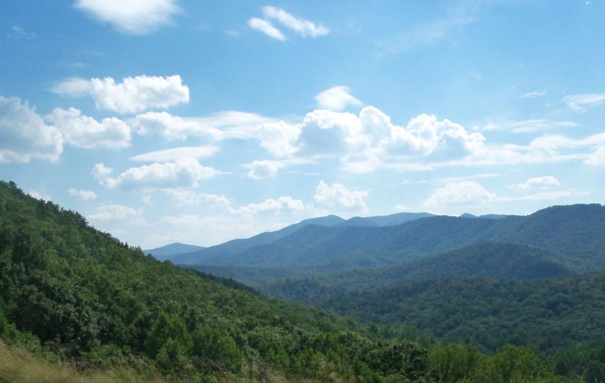
I rode this as an out and back from the trailhead, and may have interacted with the Boyd's gap trail as well- it was hard to tell, though you never feel lost. The views are fantastic, with the lake below you, small wooden bridges over streams coming down the hill, quiet forest.
The best part? I give this trail 5 stars because the ride back in was so fast, and so fun. Along with views, trail is quiet, well maintained, nice banks in the switchbacks and turns. If your looking for about 11-14 miles of pure fun, this was it, and we all loved it.
Not a bad trail at all. I gave it a 4 because I have been riding all over the country and if the top stuff is a 5 then this is not that close. Fast, flowing with decent scenery
This trail is really fast if you have the legs for it. Very fun pedaling as hard as you can picking up speed threw all the turns.. Best way is from Boyds gap parking lot towards the highway bridge.
I really like this trail. Beautiful setting. Seems well maintained. You can really pick up speed on some sections. There was a rattle snake in the middle of the trail. A first for me.
Ran the trail from the bridge at hwy 40 to Boyd Gap out and back. All in 13.4 miles. Great running trail, rolling hills, bikers must love it. Fast, smooth, flows well. I'll definitely come back for another time thru.
With only about 250 feet of overall elevation gain in one direction, this in and out trail is like riding a bullet train if you've got the legs and lungs to keep you going. There are however a few things to keep an eye out for:
1) blind corners: it is commonplace to come into view of oncoming traffic with less than 15 feet between you.
2) thorns: with the encroaching vines so close to the trail, thorns are draped across throughout the entirety of the trail. I've racked up a ton of flats.
3) wet foot bridges: don't hit the bridges at anything faster than a walking pace when its wet. Tons of slimy mildew ensures an exciting time.
4) off-camber turns: there's a couple of turns at the end of blazingly fast sections that will spit you out into the great wide open.
Fun intermediate ride doing an out and back either from the 64 bridge kiosk or parking at the Boyd Gap lookout. Be aware of other riders on blind corners.


 4
4
This was the first true mountain bike trail I ever rode, with a rented mtn bike while on vacation. I caught the bug and ride this anytime I am in the area. There are a few (maybe 500 yds out of 6.8 miles) of technical stuff - rocks and roots - you need to make or you are sliding off the trail. First time I rode I thought I was gonna die - heat & humidity. Just rode it twice while on vacation last week and killed it ... twice. Be aware that this is two-way singletrack so as you come screaming around a blind corner you may make a new mtb biking friend that is screaming around the same corner from the opposite direction. From trailhead runs 6.8 miles to Boyd Gap Overlook and then on the same end of the parking lot but on the other side you can take Boyd Gap trail which is high-speed, rocky downhill, then up the raft put-in road back to Boyd Gap and back to the trailhead ... about 15 miles. Fun, flowy and tight but lots of fun!!! Will ride this every time I'm in the area. In fact, as we left to come back to TX, I stopped at the trailhead and walked down 50 feet or so just as a remembrance of the fun.
| ThankMy favorite trail ever. Fun, relaxing, beautiful. Fast and flowy. Views of the river, wildlife spottings, zooming through the forest. It doesn't get better!
| ThankLove these trails. Come back every year for the cohutta 100 and big frog 65. Fast flowy section of trail.
| ThankThis is my kind of trail. Pure fun and flowing. Seven miles one way and then back. You can get good speed both ways. Shady, well kept, some scenery. elevation 684 ft. Sept 5, 2017.
| Thanki loved this trail, My son and i were staying at Mulberry Gap in Eljay GA we drove over for the day to ride and make our yearly white water reservations,. the only thing i would warn anyone of is the poison ivy :( it ate me up i 'm staring week two of it argggg. but love the ride
| ThankI am getting a bit philosophical here, but this trail really made me think "what is it I look for in a trail?" There is nothing particularly technical about this trail, nor anything that makes you think you might face imminent injury. But I get super-hyper technical at home in Markham, FL, and I can face all the imminent injury I can handle at Santos, FL.
Epic, well known trails like Pisgah- where I have also ridden can do both those things, and are, I guess epic partially for that reason. And I love Pisgah. A place like Pisgah represents a massive challenge, and sometimes that's what I want in a ride and a trail.
But THIS trail was some of the most fun I have had on a mountain bike. I have ridden all over Florida, Alabama, Dupont and Pisgah, and over at Tanasi. This was fun in a XC way, with less downhill fun than those bigger downhills. There is plenty of climbing here, but none of it requires a granny ring or hike a bike, as some parts of Tanasi (down the street) required of me, but its more than enough to get the legs burning and lungs pumping.
I rode this as an out and back from the trailhead, and may have interacted with the Boyd's gap trail as well- it was hard to tell, though you never feel lost. The views are fantastic, with the lake below you, small wooden bridges over streams coming down the hill, quiet forest.
The best part? I give this trail 5 stars because the ride back in was so fast, and so fun. Along with views, trail is quiet, well maintained, nice banks in the switchbacks and turns. If your looking for about 11-14 miles of pure fun, this was it, and we all loved it.
| ThankFlowy trail with lots of speed. I've ridden this trail 50 times or more and it never gets boring.
| ThankNot a bad trail at all. I gave it a 4 because I have been riding all over the country and if the top stuff is a 5 then this is not that close. Fast, flowing with decent scenery
| ThankGreat ride. Flowing and fast. Lots of leaves and wet but in great shape. Word of warning, this is an active hunting area so please wear bright colors.
| ThankFun flow trail.
| ThankAwesome trail.
| ThankThis trail is really fast if you have the legs for it. Very fun pedaling as hard as you can picking up speed threw all the turns.. Best way is from Boyds gap parking lot towards the highway bridge.
| ThankI really like this trail. Beautiful setting. Seems well maintained. You can really pick up speed on some sections. There was a rattle snake in the middle of the trail. A first for me.
| ThankRan the trail from the bridge at hwy 40 to Boyd Gap out and back. All in 13.4 miles. Great running trail, rolling hills, bikers must love it. Fast, smooth, flows well. I'll definitely come back for another time thru.
| ThankGreat trail overall. Flows well and lots of speed.
| ThankAlot of fun. Nice flowing singletrack and close proximity to other trail systems makes for a fun day.
| ThankWorth the ride,,and connects to so much more
| ThankGood beginner trail. Great for newcomers to the sport and in close proximity to Boyd's Gap and Tanasi.
| ThankWith only about 250 feet of overall elevation gain in one direction, this in and out trail is like riding a bullet train if you've got the legs and lungs to keep you going. There are however a few things to keep an eye out for:
1) blind corners: it is commonplace to come into view of oncoming traffic with less than 15 feet between you.
2) thorns: with the encroaching vines so close to the trail, thorns are draped across throughout the entirety of the trail. I've racked up a ton of flats.
3) wet foot bridges: don't hit the bridges at anything faster than a walking pace when its wet. Tons of slimy mildew ensures an exciting time.
4) off-camber turns: there's a couple of turns at the end of blazingly fast sections that will spit you out into the great wide open.
Enjoy the ride, but be safe!
| ThankFun intermediate ride doing an out and back either from the 64 bridge kiosk or parking at the Boyd Gap lookout. Be aware of other riders on blind corners.
| Thank