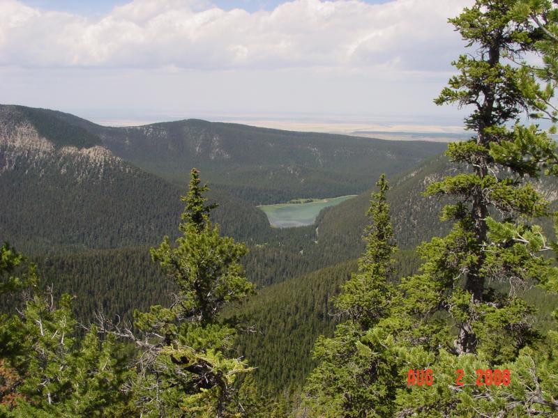
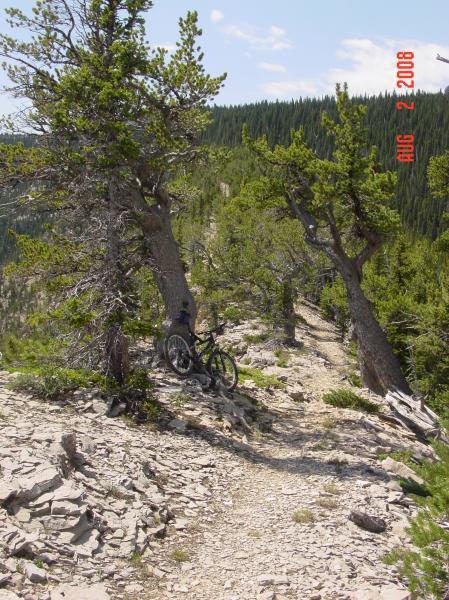
The Big Snowy mountains don't look like much from a distance, but once in them, they quickly become quite rugged, steep, and beautiful. To start the ride, go back down to the campground and take the trail that heads off to the right by the bathroom. After you descend a bit on the well maintained trail, it will become true singletrack next to the lake. Take the fork that branches uphill from the lake (Grandview Trail). There also be a cutback marked as a horse cutoff and the way back to the Uhlhorn trail--Ignore it. The climb is gradual at first with level portions where you can recover. THe higher you go, the steeper and more consistent it gets. At the lower elevations, the trail is sweet, forest singletrack with enough rocks and roots to keep it entertaining. It is also surprisingly lush here, As you climb higher, parts are covered with deep, loose shale, making the climbing even more difficult. At about 3.5 miles, look for the spur trail to Grandview point--it's worth the short trip for the fantastic view. After you rejoin the main trail, it gets really steep. A little over 4 miles, there is a short downhill, followed by another brutal climb. Some very tight, steep switchbacks will force dismounts. At about six miles, you will see a sign for the Dry Pole trail, but there doesn't seem to be any trail there--just keep on straight. After another .4 mile, there will be some very rough going that will cause a portage--i'ts steep, loose, and there is some exposure, making carrying your bike a littly sporty. After you carry your bike back up to the ridge, it's all gravy. The first great thing is the spur trail (hiking only) to the ice cave. Stash the bike and head down the spur for about .3 mi. It's an easy climb down into the cave and, even in August, there may be a column of ice from ceiling to floor (see pics)! It's well worth the extra effort. After you climb back up to the ridge, you'll follow the ridge top, navigating by cairn as the trail disappears completely). Take time to admire the views. To the northeast are the Judith Mountains, the Mocassin Mountains to the North, the Highwoods to the Northwest, and the Little Belts to the West. On a clear day, you can even see the Crazy Mountains to the Southwest. At about 8 miles, the ridge trail heads right and the Uhlhorn trail, your big payoff, continues more or less straight. After a little more ridgetop riding and some bobbing and weaving throu the hardy pines that inhabit this rugged environment, you'll begin one of the finest descents anywhere on the planet--I defy you not to hoot n' holler with joy (if you're an advanced rider--it's challenging in places). You'll descend 2200 feet in just three miles, including over 1700 in less than the first two. Up high, you'll have to surf some loose shale, but when you ge to the middle portion, you'll be on the best singletrack imaginable--narrow, steep, tremendous flow and a few opportunities for some air. The bottom third is less steep and punctuated with lots of roots and small drainage cuts across the trail--be ready to get light on your feet. There are a couple tight switchbacks and some deadfall that will check your speed. Although only 12 miles, this could have easily been categorized as "epic" and the climb up from the lake definitely makes it worthy of "tough climbs" status. But it's this absolutely rockin' descent that really stands out--it more than justifies the pain of the climb. What a treasure in someplace you wouldn't even think of looking--worth a trip from just about anywhere!


 2
2

Rode this about a month ago, note that the park/campground is currently closed, which means you have to park outside the road gate and ride a couple miles up the road before starting the ride. Not a lot of maintenance happening on the trails either, plenty of downed trees on the climb and descent.
| ThankEpic climb. Only made it up to Grandview Point because it was getting late and went back down the uphill trail. Still great fun. Wish I had more time to make it up to Ice Caves and do it proper.
| Thank"One of the finest descents on the planet" Double thumbs up to that! Love that trail!
| Thank