
Silver Plume is a small historic mining town located along the I-70 corridor in central Colorado, one of many kitschy attractions en route to the ski resorts that dot the same stretch of interstate. Located in Clear Creek County, an old railroad grade snakes up the mountain that has become a secretly-popular place for hikers and cross country skiers. When researching what trails I could do after a day of snowboarding, several fat-minded friends suggested that I investigate the Argentine Pass trail.

The town is small, with a population of around 170, and getting lost is nearly impossible. Its rich mining history, scenery, and ghost town lore has earned Silver Plume historic district status and attracts a fair number of visitors annually. I would postulate that very few of those visitors, however, travel to the Plume to discover fat biking. That is what intrigued me the most about it.
Over past seasons I’ve learned a few critical strategies about fat biking in the mountains. First, it is really nice to go somewhere off the beaten path so that you can get away and avoid crowds. Secondly, if it is too much off the beaten path, chances are the powder will be too deep and essentially unrideable. It is important, therefore, to find a place that is frequented by show-shoers and cross-country skiers to pack in the snow, but just remote enough that you aren’t yielding every few hundred feet when conditions are ideal.
The Argentine Pass trail fits that bill, and is also very convenient after a half day of snowboarding to work the “other” muscles in the legs.
The start of the trail is conveniently located off of Exit 266; simply exit, take a right onto the access road, and find a place to park along the roadside. It’s that easy. There is a sign that marks the start of the trail on the south side of the road before an intersection.

The day I explored this trail it was later in the afternoon on a bluebird day. It was a Friday, and there hadn’t been a fresh snow in several days. Still, I found the start of the trail easy to find, and at that point it was very well packed by hikers and skiers, which gave me hope.
What surprised me the most about the Argentine Pass trail was how gentle the grade was. There aren’t that many reviews on Singletracks, and the ones that are there were written when there wasn’t snow on the ground. Re,views did allude to an easy grade, but with some technical rocky sections–something I didn’t experience, since snow filled in all the rough spots. Nevertheless, the trail started out with what I would wholeheartedly claim is a beginner grade–if, that is, you can ride at 9,500ft elevation without any respiratory problems.

The first mile was really easy going, with a nice, clean, packed trail due to foot traffic. As I neared what appeared to be a water tower, however, I began to break trail. The grade toughened a bit, but was still very manageable. It looked like no one had hit the trail in a while, but there was only 3-4 inches of powder, easily broken in by the Maxxis Minion 4.8″ tires on my fat bike. The hum of traffic from I-70 was in the distant background, akin to a brook, and there were animal tracks everywhere: deer, rabbit, birds, bobcat, mountain lion, and bears. Yes, bears, in January. In fact, I saw bear tracks in several other places along the trail as I climbed.

The trail was beautiful. The sound of traffic disappeared somewhat, and I felt like I was deep in the backcountry, slowly climbing a narrow trail sheltered by tall trees, though I could easily peer through the cover as I climbed and see the I-70 traffic moving down below. The forest was otherwise silent.
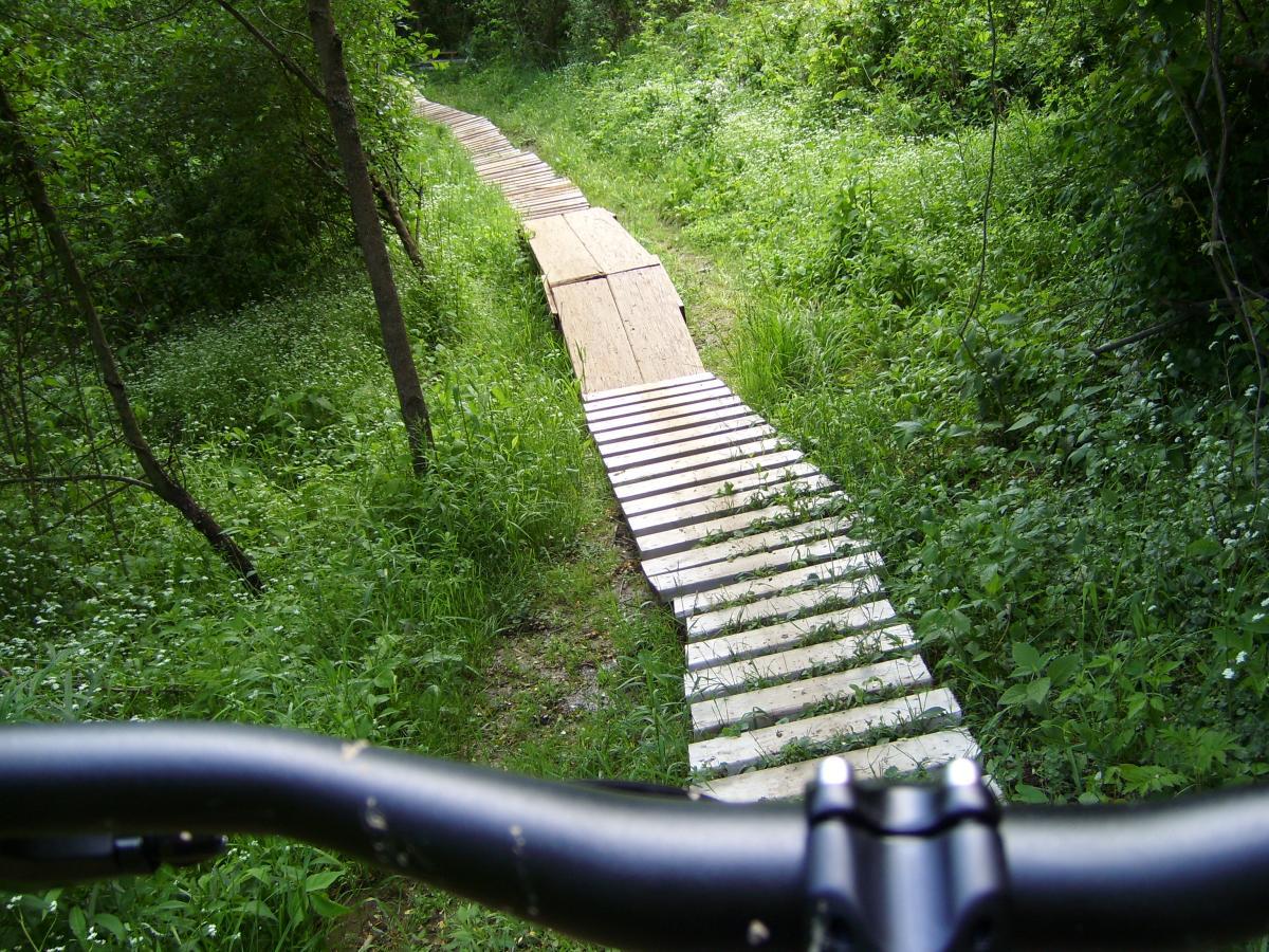
I came across a few defunct wooden structures, part of the silver plume itself, which were very cool to see. The first was nested in a switchback, where the old railroad cars could tuck into the plume site, load up, and change direction to go down or uphill. It gave me a sense of respect for the miners out here in the elements at altitude searching for silver. What a difficult and laborious task!
The higher I went, the harder things got, however. Initially, the packed track was about 2-3 feet, but as I climbed that became narrower, sometimes as little as 6-8 inches. It also became harder to tell where the packed portion was located, and occasionally my front tire would slip off into the deep and I would posthole to the knee.

At about 2 miles in things really got difficult as I entered tight, barren, aspen trees. The track was consistently narrow, and I started pushing my bike up on its rear wheel in front of me so that I could stay on the packed portion and pack it in more without destroying it. I was hoping, that at some point, thing would get easier, but everytime I made an effort to get back on the bike and ride, I didn’t get very far before my bike fell into the pow. There were sections where a bear had actually walked the trail, packing it in, which made that section easier. I found that very ironic.

After about another 1/2 mile of this, I came to the sad realization that I wasn’t going to make it to the crux of Argentine Pass with enough time and daylight left to return. I had gone 2.5 miles, climbed 1,020 feet, and topped out around 9,900 feet. I made the decision to turn around and descend right before Pavillion Point. I fueled up, layered up, dropped my seat, and prayed that I could stay on the packed portion and have a fun, fast ride down. The upper portion took a lot of balance, but I managed to stay on the trail. It became easier as I descended, and the last half of the descent was wicked fast and fun as I gained confidence and put the pedal to the metal. My max speed was 28.6mph, and I really wish that the trail was a bit more reliably packed so that I could have just floored it downhill. I had a couple of close calls, sliding around some corners, but managed to stay upright the entire time. I could not wipe the grin off of my face for hours after that!

The Argentine Pass trail is a blast, no doubt about that.
I am sure some locals might cringe at the prospect of this trail gaining a bit of popularity, but I don’t think this review will suddenly make everyone rush out and ride it. It is not a destination trail by any means. It would be nice if a few more people got on it from time to time to pack it in. The upper section, which stays under 10,000 feet, can be connected to Leavenworth Creek Road, which also connects to Guanella Pass Road, as well as several spurs, so you could ride for hours and explore a lot of scenic territory.

If you are looking for a fat bike ride after hitting the slopes, this is a great trail to explore.
Here is a short segment of video I shot on the descent; it’s nothing fancy but it will give you an idea of what to expect:


1 Comments
Feb 6, 2016
btw, the easy grade should have been no surprise--old railroad grades are always low angle.
Oh yeah, Nice Borealis too!