
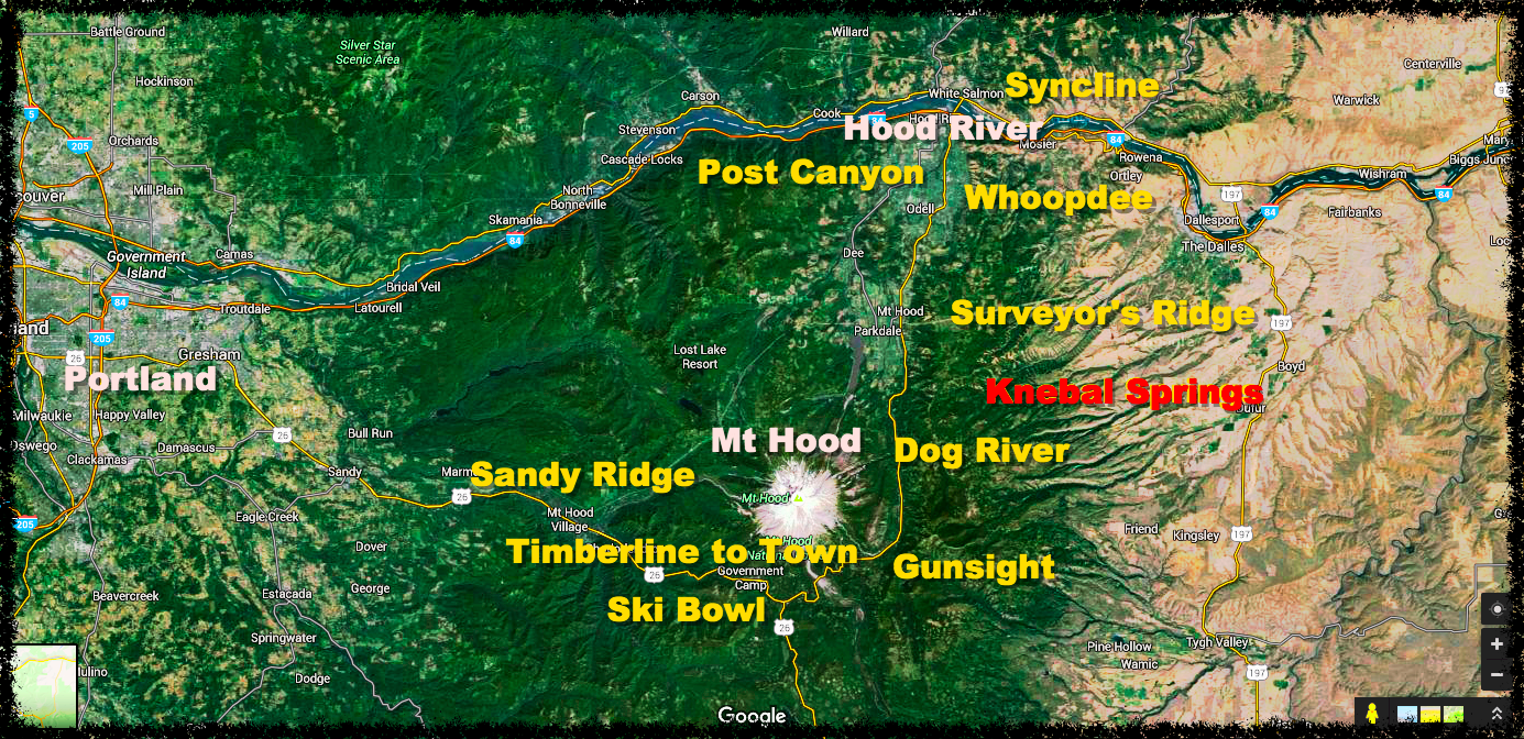
The Hood River Valley courses nearly 40 miles along Highway 35, bound by Mount Hood to the south, the Columbia River to the north, and the Cascade Range to the west. A large ridge system runs the eastern border of the valley where, 26 miles south of Hood River, OR, National Forest Development Road (NFD) 44 climbs into the ridge and beyond, providing access to the largest single network of mountain bike trails near Hood River, collectively known as the 44 Trails:
- Dog River
- Surveyor’s Ridge
- 8-Mile
- Knebal Springs
- 15-mile
- Cedar Creek
- Cooks Meadow
- High Prairie
- Gunsight Ridge

Most trails within the 44 network can easily be linked with at least one or two others (like Dog River and Surveyor’s Ridge) for a solid 2-3 hour ride so, for the sake of thoroughness, this is how we will report on it. That said, it is possible link several options for a truly epic day in the saddle. For this ride report, I explored the Knebal Springs and 8-Mile loops, which lie at the heart of the 44 Trails network.
The Ride
The Knebal Springs and 8-Mile trails form side-by-side loops, each branching from a shared common pathway forking 0.25 miles in from the main trailhead (TH) along the Bottle Prairie Trail. I describe Knebal Springs counter clockwise and 8-Mile clockwise, as that’s how I rode them, but both would be as enjoyable in the either direction. Both loops have fast, flowy, XC-type descents, are devoid of any overwhelmingly-technical sections, and although there’s plenty of climbing, all of it is gradual, making for a perfect intermediate-type ride.
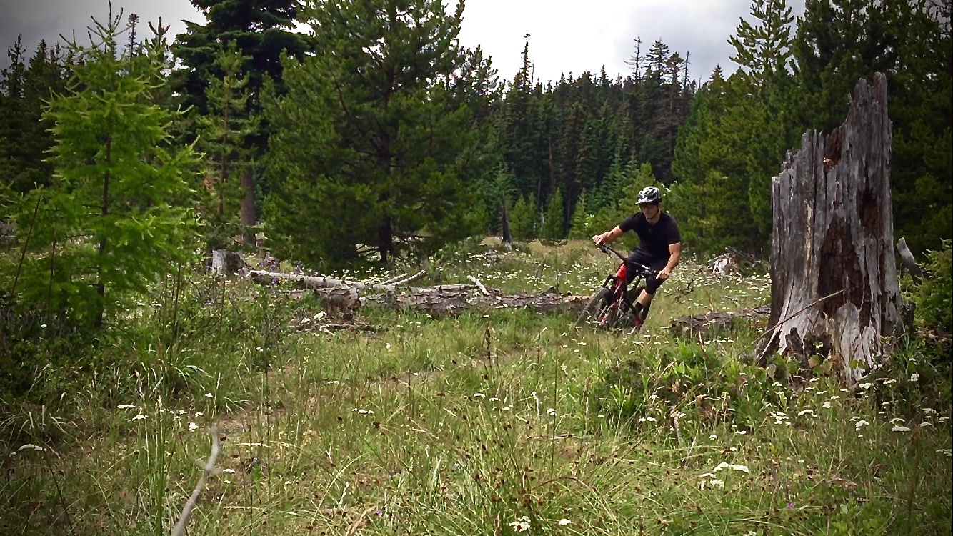
Knebal Springs was like eating dessert first, as a 1,300-foot descent over 3.5 miles shows up after only climbing less than a mile up a ridge. Corners both wide and tight are punctuated with small root drops, whoops, and the occasional rock patch, catering to those who live for popping in and out of turns while executing effective pumping skills for speed. The final half-mile leg of downhill dives off the opposing ridgeline where hot, heavy feet are rewarded by the spray from small stream crossings, before paying it all back over the next four miles of climbing.
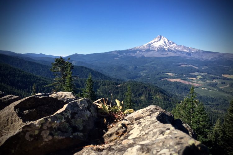
A short descent follows the climb out of Knebal, bringing you back to Bottle Prairie where repeating the first quarter-mile section meets up with the junction to 8-Mile. From here, the trail skirts a ridge, plunges a half-mile down, and then opens up to an expansive view along another short climb below Fivemile Butte. Here, a fire tower accessed by a short side trail provides a perfect stop to fuel up before the nearly two miles of switchbacking ridge descent, followed by a slow, but beautiful, climb along 8-Mile creek and back to the car.

Because the 44 Trails are more remote and higher up in elevation than others in the Mount Hood-area, they succumb to many a tree fall and other wintery damage, and they are typically shred-ready mid to late June. Situated to the east of the Cascade Range also means a drier climate and, subsequently, very dusty conditions in mid to late Summer.
The planning, building, and maintenance of the 44 Trails is carried out by The 44 Trails Association, a non-profit organization staffed entirely by volunteers and financed by fundraising events and donations. While the association’s involvement is heavy in stewardship of the trails surrounding NFD 44, their efforts are supported by others including: Backcountry Horsemen of Oregon, Columbia Area Mountain Bike Advocates (CAMBA), Northwest Trails Alliance (NWTA), Central Oregon Trails Association (COTA), and Hood River Area Trail Stewards (HRATS).

StumptownRider’s Post Bike Bite & Beverage
StumptownRider advises a visit to Walking Man Brewing in Hood River for the Homo Erectus (Double IPA) and a veggie burger (add avocado with fries).
Getting There
From Hood River, head south on Highway 35 for 26 miles to National Forest Development Road 44 on the left. Follow NFD Road 44 up for 6 miles and turn right onto Dufur Valley Road. In 2.3 miles on Dufur, look for the Bottle Prairie TH on the left where both 8-Mile and Knebal Springs trails intersect.
Knebal Springs/8-Mile
- Type: Loop
- Difficulty: Intermediate
- Miles: 16
- Elevation Gain: 2,780ft

The Hood Report is a series of ride reports on trails in the Mount Hood region located along the Mount Hood corridor through the Hood River Valley along U.S. Route 26 in north central Oregon. Read our introduction and overview on Hood-area riding here.


1 Comments
Oct 27, 2016
I'd definitely recommend doing 8-mile clockwise for the best descending and climbing experience.
The trailhead is a bit hard to see from the road. Watch your GPS closely.