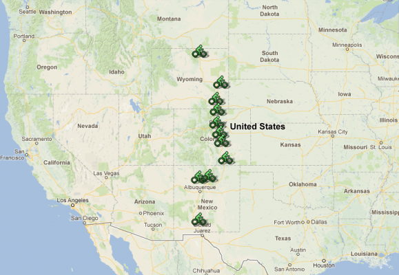
Beginning at a fork off the East-West I-10 in Las Cruces, NM, and ending at a merge with the East-West I-90 in Buffalo, WY, Interstate 25 spends much of its length flirting with the Eastern boundary of the Rocky Mountains. You might think this kind of topography would lend itself to great mountain biking along the way—and you’d be right. This zone where the mountains, desert, and prairie all come together provides a great deal of easily accessible, yet high quality singletrack.
1st Stop: Dona Ana, NM
1-25 Exit: 15. Trailhead distance from exit: 2.7 miles
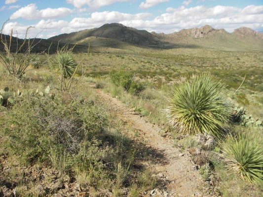
Assuming you didn’t actually start in Las Cruces, you’re probably ready for a ride about now. And lucky for you, the wonderfully varied Dona Ana trail network is only a few minutes off the interstate. This is a perfect stop for you to customize a ride to your liking with the easier trails closer to the trailhead and more challenging routes farther out.
2nd Stop: White Mesa, NM
1-25 Exit: 242. Trailhead distance from exit: 25.7 miles
If you need a singletrack fix sooner rather than later, head for the Elena Gallegos trails on the East end of Albuquerque. But if you’ve got the time and want a truly unique Southwestern singletrack experience, make the jaunt over to the wonderful White Mesa loop. This trail was a cooperative effort with the BLM that had mountain biking in mind from its inception. You will be rewarded with a high quality, all singletrack loop amidst real posses-chasing-outlaws-in-the-desert scenery. Just remember to bring plenty of water.

3rd Stop: Atayala Mountain, NM
1-25 Exit: 282. Trailhead distance from exit: 6.4 miles
Here’s your opportunity to bag one of the seven best climbs mere minutes from the interstate. Hit this one if you’re ready for some serious elevation gain in a short distance. It’s also the best way to rise above the heat in the summer. If you’re looking for something a little less strenuous but still full of that Santa Fe charm, opt for the nearby Dale Ball trails instead.

4th Stop: Sugarite Canyon State Park, NM
1-25 Exit: 452. Trailhead distance from exit: 8 miles
After departing Santa Fe, you will enjoy pinion and juniper forests all the way to Las Vegas (NM). After that, it gets pretty dull as you will share the next hundred miles of desert prairie with antelope and bored New Mexico State Troopers doing their best to help the state’s revenue shortfalls. As you approach Raton, however, you will see the forests and mountains return, meaning this is a good time to stop for a ride. The main loop around Sugarite Canyon State Park (best done clockwise) is just the ticket. The mostly singletrack trail is very narrow, offers great mountain biking variety and, despite being a State Park, feels very remote and you will likely have the place to yourself, even on a weekend.

5th Stop: Lake Pueblo State Park, CO
1-25 Exit: 97. Trailhead distance from exit: 8.4 miles
Although you’re well into Colorado by now, the mountains remain far to the West, but that doesn’t mean you’re out of great riding options. The trails around Pueblo Reservoir will satisfy either the technical freerider looking for some quick hits or the cross-country junkie looking to pile on some miles. The trail network has a tight group of short downhill runs over obstacles, big drops and loose shale. The descents aren’t long, but they are very entertaining and you can take one of the smoother trails back up and do laps to your heart’s content. If you’re just looking for a nice long aerobic workout, skip the downhills, proceed to the other side of the ravine and feast on over 20 miles of narrow cross-country ribbon with occasional exposure to the reservoir below.

6th Stop: Red Rock Canyon Open Space, CO
1-25 Exit: 24. Trailhead distance from exit: 4.9 miles
Colorado Springs is chock full of highly accessible Class A singletrack, so why pick this one? Three reasons: 1. It’s the quickest jaunt off the interstate, 2. You can get genuine red rock scenery that rivals Garden of the Gods, which lies just across the highway but prohibits bikes on the best trails, and 3. It’s right next to Rudy’s Barbeque, an excellent post ride refuel. Most of the lower reaches of the open space are wide and smooth, but there are a few great techy spots amongst the easy stuff, and those who venture higher into the hills will find plenty to keep their wild side entertained. If you’d rather have a nonstop technical extravaganza, head for Palmer Park instead.

7th Stop: Deer Creek Canyon Park, CO
1-25 Exit: 194. Trailhead distance from exit: 16.7 miles
Denver’s a big city and the only thing close to I-25 is Cherry Creek Reservoir, and you probably didn’t come all this way to ride that. But if you grab the C-470 loop around the west side, there are a multitude of options, including the fantastic Dakota Ridge I profiled in the I-70 trip. For this trip, we’ll grab the wonderful Deer Creek Canyon. If you start from the bottom, you’ll get a classic (read: difficult to brutal) front range climb with a bonus: The Wall of Shame, an extra steep, rocky section that smacks you in the face after you’re already fatigued from climbing. Very few have cleaned this going up. But never fear, if you can’t clean it, it’s a short walk and, once on top, you get a beautifully forested loop and then that brutal climb turns into an excellent descent for the trip back to the car.

8th Stop: Devil’s Backbone, CO
1-25 Exit: 257. Trailhead distance from exit: 8.8 miles
Between the prairies of the East and the mountains of the West lies a jagged hogback where bikers can just cruise or seriously challenge themselves. The further you get from the trailhead, the more challenging the trail becomes until you’re constantly going up and down ledges without a break. If that’s not enough, you can add countless more miles by connecting to the Coyote Ridge, Blue Sky, and even on into Horsetooth and Lory Parks for a seemingly endless orgy of singletrack.

9th Stop: Curt Gowdy State Park, WY
1-25 Exit: 10. Trailhead distance from exit: 24.5 miles
This one’s a good half hour off the interstate and the State Park does charge a fee, but I guarantee you’ll get outstanding bang-for-your-buck if you make the trip. Wyoming had bikers in mind when they laid out and built these trails and it shows as this has become a sort of mini-Mecca for knobby fiends, drawing many Colorado riders out of their usual haunts. The trails are well laid out and marked, allowing even a first time visitor to build a route to his/her liking with regard to both mileage and technical challenge.

10th Stop: Guernsey State Park, WY
1-25 Exit: 92 Trailhead distance from exit: 18.8 miles
As the prairie widens, you’ll actually head East to get to this one. Want some technical challenge in a surreal landscape? Want to have someplace all to yourself? Remember, the entire state of Wyoming, which is almost as big as all six New England states combined, barely exceeds 500,000 in population, and not many of them mountain bike. This is the place.

11th Stop: Clear Creek Trail, WY
1-25 Exit: 298. Trailhead distance from exit: 4.5 miles
As I-25 draws to its endpoint in Buffalo, WY, you have one last chance to grab some beautiful singletrack. The basic Clear Creek out-and-back provides a few miles of peaceful, easy creekside riding. Those seeking more adventure or exertion can explore further up canyon. Either way, it’s a fitting conclusion to your I-25 odyssey.
These are just a few suggestions based on proximity to the Interstate, quality of singletrack, and overall variety, but there are tons more along I-25, especially through central Colorado. A description of the opportunites along just this 70 mile stretch could take a dozen blog entries all by itself. Before you go, be sure to punch in a few locations along the way on the Singletracks map and see if there’s anything else that calls to you!






8 Comments
Feb 21, 2013
I gotta disagree with stop 6(red rock canyon).
Palmer park which you mentioned is a much better ride and just about the same distance off the interstate(about 1/4 mile further)
Feb 21, 2013
Having said that, Palmer is still my fave and another reason I didn't put it here is I'm planning an in depth report for a later article.
Feb 22, 2013
Feb 25, 2013
Feb 22, 2013
Feb 21, 2013
Curt Gowdy is on my to-do list as are Lake Pueblo and White Mesa.
That Clear Creek trail looks gorgeous, too--I'd love to hit that one day!
Feb 22, 2013
Feb 24, 2013