This is mainly a cross country ski trail but this will give your lungs and legs a workout. Very beautiful north country trail with lots of sand. I generally bike 15 miles or so a weekend at my local park which it burchfield in holt, but when I was done with this my GPS told me I had gone 12 miles and I felt like I had ridden 20.
First time through I missed the turn for point 7 because of the awesome descent from 6 and the trail down to 9 was a great ride with one of the few points I could get some real speed because the trail was packed. I turned around and did the climb back to 7 and rode to 8 which is where the trail isn't marked well. ended up on another large climb that I ended up having to get off the bike for a minute to end up at a dead end at the top. But the trip down was worth the burning lungs and legs and ended up back at the trail. Got lost again at marker 8 where the arrow seems to push you down a path that i found out later on a map was call amys trail. This is thick sand and was almost un-ridable. There were blue markers leading past this trail but the grass was so high I missed it. ended up seeing the trail again about a half mile down amys trail and was able to jump back on it to go to 9 and 1. I have pictures and will post them because there are lots of points of interest that are marked out as well as some history of the old logging roads and train beds that make up part of this trail. Between 1 and 2 you are greeted with more hills and a fast descent to 3. If you are in the area and don't mind pedaling hard in sand this trail is definately worth jumping on. It took me 1:30 minutes to complete with 2 detours off the loop, stopping to take 2 logs off the trail, and having to walk part of a hill.


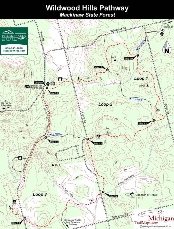

These trails are for x country skiing. Not good for bikes. A few good sections, but in my opinion not really worth the stop to ride. Not singletrack.
| Thankfun trail but be prepared for sand. this is northern michigan so you can practice on the beach but for first timers its a blast. but lower your tire pressure.
| ThankPros: well-maintained, wide, nice scenery, not high traffic.
| ThankCons: Lots and lots of sand. Sand at the base of downhills, that can catch you unaware. Most sand is hidden- fallen leaves and sparse vegetation covering it. Most of trail is wooded; be sure to wear bug spray. I'd try it again with a fat tire bike, but my 29er's tires weren't a great fit.
I enjoy this trail because it is a good distance for a morning ride. Most of the trails are wide (logging roads and train beds), but some side paths exist with a bit of technical challenge - if you can find them! There are some sandy areas, but in general the trails are pretty well maintained - not groomed, like down state.
| ThankThis trail appears to not be ridden much, but I think it certainly has some potential. I rode this in July of 2010. The trail is marked, however the plant life has grown pretty high, so like the previous reviewer, it's easy to miss points on the trail. The area is very scenic and it was worth the time to ride. It's not groomed like trails down state, but after riding parts of the VASA and North Country Trail, Wildwoods would not be out of place as part of either of those trail systems.
| Thank