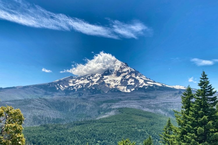
Route Overview:
Surveyors Ridge Trail is a premier mountain biking route in the Mt. Hood National Forest, offering a quintessential Pacific Northwest riding experience. Stretching approximately 13.8 miles (one way) from Forest Road 44 in the south to Baldy (power lines) in the north, this trail is renowned for its singletrack, moderate climbs, and breathtaking vistas of Mt. Hood and the Hood River Valley, making it a fun challenge for intermediate and experienced riders.
Trail Features:
Riders can expect a mix of aggressive short climbs and descents, a couple technical rocky sections, and open alpine meadows. The trail offers unparalleled views of Mt. Hood, especially from the ridgeline traverses. The northern end near Baldy provides expansive views of the Hood River Valley.
Access and Navigation:
The trail can be accessed from the south via Forest Road 44 or from the north near the power lines at Baldy. Note that the trail runs parallel to Forest Road 17, which can serve as an alternative route or bailout option.
-Greg Doan, 44 Trails President


 9
9

Rode the trail S to N. Fun trail and great views of Hood. Took me way longer than it should have to ride, because I had to keep stopping and looking at the mountain. My take aways were
1) don't ride back on the road, stay on the trail, it's more fun
2) don't bother with Bald Butte, climbing back up isn't worth the so-so double track ride down
3) saw a bear on the trail, so keep your head on a swivel out there
Thanks to 44 Trails, I played around on some of the other trails, and they look great
| ThankTraversing Surveyor's Ridge has been billed by many a must-ride, Oregon classic, but not for reasons you might think. While you will find a variety of surface and terrain from smooth needle-pack under thick forest to rugged mountain side exposure; impacted rock gardens, and swooping descents; the real reason to ride Surveyor's Ridge is for the views of Mount Hood not found anywhere else by mountain bike in the Hood River area.
| ThankSurveyor's proper begins at the top of the Dog River Trail - a six mile, 2,000-foot ascending/descending trail - and runs north/south for 10 miles if you stop short of the the ridge's descent. Surveyor's is in constant undulation as it hops from one side of the ridge to the other exchanging unparralled panoramas of the vast Eastern Oregon backcountry with the lofty heights of Mount Hood.
Surveyor's leaves a little to be desired in terms of fun factor as any descent along the ridge is too often met with short and sometimes steep grunts keeping in check any chance for sustainable speeds. Just as fast as you enter a section of flowy goodness in the downhill direction, you are met with an equal but opposite pitch going uphill interrupting rhythm. Alas, what Surveyor's lacks in thrilling singletrack, it makes up for in views which has added to my own perspective of what "fun" really is.
Read my entire report on Hood River-area riding by searching The Hood Report on Singletracks.com
Absolutely great trail. I rode Dog River to Surveryors Ridge to Oak Ridge. You can leave a car at Oak ridge, pedal down the road a ways, go up Dog River, and end back at your car. It's a big day, but this trail is a blast. Dog River is a dog of a climb, Surveyors is amazing singletrack, flowy, little techy, unreal Mt Hood views. Oak Ridge is steep, loose switchbacks and very entertaining. Highly recommend this ride. It's a solid day, so be ready.
If you just do Surveyors (shuttle), you can do it either direction. I read South-North is the way most people do, but I also have no idea, that's the only way I rode it.
| ThankIf you can only ride one trail in Oregon, make it this one. Starts with 5 miles of a fast flowing singletrack/doubletrack combination that is nothing but smiles. The journey begins in earnest at the end of the doubletrack. The next 7 miles involve ridge line rides through the forest with many open areas that reveal Mt. Hood and the surrounding valley. Enough uphill and downhill sections to keep you busy. Plenty of rocks but no overloaded tough areas. The last 3 miles is a fun filled 1,000' descent. Just before the 13 mile mark you reach parking underneath huge powerlines, where you can turn around, use Highway 17 as a loop or have your shuttle vehicle waiting.
| Thank