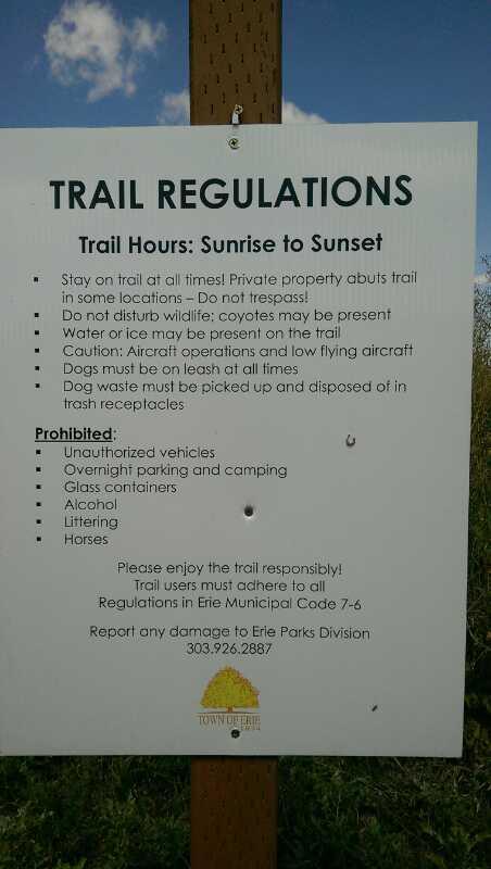
Best accessed from the Sunset West area below, you can also choose to park along Weld County Road 6 near the start. There's a nice new sign at the start informing users that this trail was just recently built and to follow all the trail etiquette rules.
Wind uphill from the start to the first junction and keep right to start the ascent up the easier track. Follow this as it makes nice easy switchbacks up to the top of the hill. There's a junction at the top which joins County Road 5, but stick to going straight and you'll start the second half of the loop.
Ascend down from here and enjoy the natural rolling nature that's been built up for plenty of air opportunities! The turns are also nicely banked so feel to open up the speeds as much as you're comfortable with.
The laps are on the shorter side, so feel free to do a few laps to hone your ride!


 2
2
Lower section of Blue run was reworked last month. changed the jumps a bit.
| ThankI love this place for working on my jumps!
Came back out with my gf and the green line is a lot smoother and faster now, I easily pumped the whole thing. Blue line is a lot of fun. Saw they were cutting a new track, looks like a lot of fun but it is nowhere near being finished.
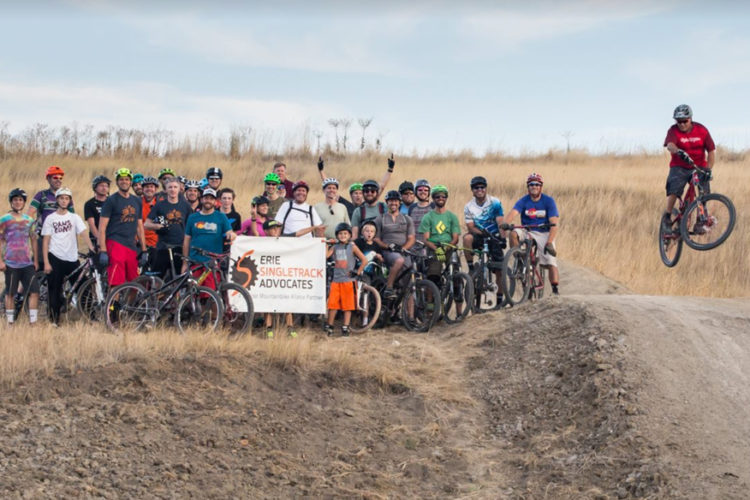
| ThankThese trails are a kick in the ass. Don't know if I would go out of my way to ride them again, but it was worth the drive to ride them once. The Blue line is a bit more advanced and doesn't flow like the Green line. Both are a lot of fun, but I would place my preference on the Green line based on fun factor. The Erie Singletrack Alliance has done a great job building these trails and I hope the build more.
| ThankNice small track it was fun. There is a newer line being done up. Live nearby so will be going here often.
| ThankFlow trails with some little doubles and rollers. Fun place to put in a few laps after work. A little on the slow and pedally side, so best suited to a trail bike (leave the travel at home).
| ThankThis is the first trail I've riden (out of 3) that really progressed my riding just from 2 visits. It has been great for doing short intervals of fast climbs and rewarding descents. The blue line is the most complicated trail I've ridden so far, but I (a beginner) and my girlfriend (a first timer) both had a blast on it. It definitely has helped me learn (quickly) proper placement/balance on the bike and to continue to keep looking ahead during multiple turns.
A great confidence builder and by far the most fun trail I have ridden yet!
| ThankSunset East Blue Line is super fun, fast and flowy. It has little jumps that can be cleared if enough speed is had. It even has a step down double that with enough speed you can go as big as you wanna go.
| ThankThe Sunset East Green Line is not as fast as the Blue Line, but has lots of rollers, tables and berms and again, if you want to go fast, you need to pedal for it. Both trails are super fun and can be connected with the Sunset West trails to do four mileish loops. Fun, fun, fun, nothing techy what so ever. They can be done on a cyclocross bike or full squish.
A fairly new trail loop, which they are still tweaking and adding, but a great afterwork ride. Just make a few loops and have some fun catching air and riding the berms!
| Thank