Snow King Mountain is a hill that rises 1600 feet from the edge of Jackson Hole. The Snow King Resort runs a chairlift up the hill all year round. It does not take mountain bikes over summer and there are no downhill trails on the ski slopes.
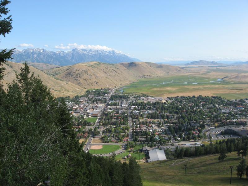
There is a four wheel drive track called Snow King Tail that zig-zags up the hill. Some intrepid out-of-town mountain bikers ride up it but it's steep and sadistic. It takes you to the top of the chairlift where the views across the town and the Elk Refuge to the Grand Tetons are stunning.
Most of the trails are well away from the chairlift on the north side of the mountain. They're cross-country trails with few new-school MTB features. They're all two way, and are shared with dog walkers, hikers and runners - flocks of them on weekends!
Two trails start from the top of the chairlift. Josie's Ridge Trail which descends steeply back to town in 2.4 miles and is nobody's favorite trail. The other one links to the summit hub at the top of Ferrins Trail.
Ferrins Trail is the best way up the mountain. It's grade 4 and starts a short way up Hagen Trail from the Cashe Creek trailhead and zig-zags its way to the saddle that is the summit hub for other trails on the mountain. It gains about 1400 feet in a steep and sweaty 3 miles. Some locals with limited time ride it to the top then turn round and ride it down again.
Putt-putt is a grade 3 trail that starts at the Nelson Drive trailhead, and goes up the north side of Cache Creek for about 4 miles. It takes in some nice views before passing the Cache Creek trailhead and carrying on up the river. It joins with Hagen at the top so together they make up the most popular loop in the network....
Hagen is a more technical grade 4 trail. It starts at the Cache Creek trailhead and goes up or down the other side of Cache Creek for about 3 miles. It's rooty, rocky and has a short section of steps that are fun to ride down if you have the skills...
Five trails can be combined for the premium ride of the network. They are Ferrins, West Game Creek, Game Creek, Cache Creek and Hagen. It's a challenging and beautiful 20 mile loop that takes you right over and behind the mountain. It offers some excellent cross-country riding with a genuine back-country feel.
Skyline is a grade 4 trail that starts at the saddle and goes down a ridge to Game Creek from where you can exit back to Cache Creek or go south to the Game Creek trailhead.
For a marathon of a ride right around the mountain, ride up Cache Creek on either Putt Putt or Hagen then Cache Creek, then Game Creek. From the Game Creek trailhead you have to ride back around the base of the mountain on roads or shared trails.
Sink or Swim is a grade 3 trail across the lower slops of the ski field not far above town. It links to the Cache Creek trailhead....
There are lots of sign posts to help you find your way and some even have a network map showing where you are. There is a toilet at the Cache Creek trailhead.
 | Cache Creek - Game Creek Loop | 10 mi | |
 | Ferrins-Game-Cache Loop | 12 mi | |
 | Five Way Meadow | 3 mi | |
 | Putt Putt | 2 mi | |
| Sink or Swim | 2 mi | |
| Skyline Trail | 7 mi | |
| Snow King Trail | 2 mi | |
| Wilson's Canyon | 5 mi |


This is such a fun ripping ride! Lots of climbing, we actually rode Ferrins up and down, a 7 mile ride.
Be mindful on the uphill that its a bi-directional trail and you may have riders ripping down, but EVERYONE in the area was incredibly nice and followed the ''uphill has the right of way'' rule and pulled over.
I recommend carrying bear spray, I missed a close encounter on a trail and this is Griz country.
| ThankDon't bother with this 4wd road up the ski slopes overlooking Jackson. Ferrins Trail is a better ride up the mountain - singletrack all the way with lots of switchbacks - but also grueling!
| ThankSink or Swim links downtown Jackson to the Cache Creek trailhead and to the top of the mountain via Ferrins Trail. It is a shared two-way trail that is popular with runners, and dog walkers. There are fine views over town.
| ThankThis is probably the most popular loop on Snow King Mountain, Jackson Hole. It has a serious climb, stunning panoramas, exhilarating down-slope riding, beautiful forests and meadows and a genuine back-country feel for much of the way. It's long enough at 12 miles and challenging enough to leave you with a sense of achievement. Take your camera!
| ThankThis is an excellent ride that takes you from the edge of Jackson Hole into the back country behind Snow King Mountain. You'll love the feeling of isolation that will creep up on you. It's challenging too and you'll end the ride with a sense of exhilaration and achievement. The downside is the flat ride on the shared path beside the highway back to town if you can't organize a shuttle to complete the loop. That's probably why the Ferrins-Game-Cache Loop is more popular. It covers some of the same ground and goes over the mountain and back down the Cache Valley. That entire loop is singletrack.
| ThankSuper fun trail! One super hard hill to climb but is so worth it! The down hill ride is one of the best in Jackson. As a heads up be careful what time you go. When the sun is setting it's rough to see on your way out to game creek. But the bike path back to town goes pass the Bird grab a beer and sit on the outside deck.
| ThankIt's great to get to the top and look down over Jackson and out to the Grand Tetons. A few more signs would be helpful so don't go without the map... And be sure to check out the Cowboy Bar when you get back to town
| ThankWe started at Cache Creek trailhead and took Hagen up to Ferrins up to Snow King Crest and then turned around and came back down the way we went up, seems like there were a number of folks doing the same thing that day. Its a bit of a climb to get to the top about 1400' in 3.5 miles but for the most part the climb is not to bad. You will be well rewarded once you arrive at the saddle with great views of the Tetons and Jackson Hole. The trip down is a blast. Very scenic and shady ride. We rode a bit on the Putt Putt trail it was pretty mild for the most part but not a lot of shade.
| ThankEasy climb up Cache Creek or go for the hillside trail up Putt-Putt or the shaded trail up Hagen's. Either way, all three converge followed by a short, but brutal hill at the divide. Once over the divide, get ready to rip-and-grip down the bobsled that is Game Creek. The Game DH is a little short-lived but super fun. Pedal out of the canyon which dumps you onto the bike path and you are quite a ways from your car. Best shuttled IMO, but not too bad of a ride back into town.
| ThankRoad up the Hagens river trail a bit, but bailed back to Cache Creek trail before the nasty climb on Hagens (there is a warning sign). Then up Cache Creek to Game creek cutoff. Turned back at this point, and took Putt-putt back down. This is an narrow up/down trail, with some steeper descents mixed in with climbs. Very fun.
| ThankDo this ride before 9 am if possible; this is a very busy area.
Note that the suggests maps are not great; just red lines onto a top map. Better maps are really needed.
See the latest map here, which includes the phenomenal Cache-to-Game trail (separate entry on singletracks): http://www.friendsofpathways.org/maps/
| ThankI have ridden half of the Top 25 trails, and I don't understand how this trail isn't in the Top 100, much less in the Top 10. Riding in early July, I found the hard packed downhills pristinely smooth, the views almost unmatched, the wildflowers comparable to Crested Butte, and the climbs to be well-planned. The trail architect and builders should be commended.
(Route: Hoback->Across Snow King->Up Putt-Putt->Up Cache Creek Road->Game->West Game->Ferrins->Back Across Snow King...)
| ThankEvery local you talk to recommends this trail, so I had to check it out.
Parked at the Putt Putt trail head.
Rode down Putt Putt trail (single track) to Cache Creek tr, then Game Creek trail, West Game Creek, and back down the awesome decent to Cache Creek. Gave us 3000 vertical feet of elevation,
Some beautiful single track, picturesque spots (and then the Tetons - wow!) and great riding.
| ThankEpic ride! Tough as hell (for a couple of flatlanders trying to become "real" MTB'rs). Rode this trail (and a couple more in the complex) on August 6, 2013. Started at the trailhead as described in directions. Rode the 3.8 or so to the Game Creek turnoff (to the right) made the steep ascent (had to walk), took our first real downhill. Flow and speed were tremendous. Took about four or five minutes to fully descend. Then the ascent back up and then down again on mountain #2 (don't know any names yet), then found Forest Canyon Trail, took it up mountain #3, to the crest and intersection with another trail (name escapes me) then finished up back on Cache Creek near trailhead. Loooooong ride. Exhausted but satisfying. Smooth and not so smooth trails and descents. Part was through a former burn/forest fire area with the trees looking like burnt matchsticks and some pretty volunteer flowering ground cover fauna all around. All in all, a butt-kicking and soul-satisfying ride. Great pics with the Tetons behind us from crest of hill/mountain #3.
| ThankI had a blast today and after riding these trails around Jackson it puts many other areas to shame. They are very well maintained and so many choices! Great area.
| ThankAfter you get to the Divide and start the Game Creek section it has some of the funnest singletrack around. It doesn't contain any jumps or root drops but it makes up for it with smooth flowing singletrack. Scenery is awesome with moose and beaver sightings possible. Cache creek part is heavily recreated but after the first few miles you won't really see anyone.
| ThankThis is a tough, steep climb up the front of Snow King that is easily accessible from Jackson.
| ThankNot challenging, but it's an essential connector. I love the views though!
| ThankSome steep, gnarly spots on this trail. Super fun descent! It's definitely overgrown in areas, though.
| ThankHere's a great trail map for this system: http://www.snowking.com/img/SKTrailMap.pdf
| Thank