This ride is intermediate ñ expert technical and expert aerobic. Get a map from the main visitor center and study it before attempting this route. This is a wild place with a lot of trails. The best time to ride this trail is spring or fall. I prefer the spring because the falls will have more flow. Summer would be almost impossible to carry enough water to safely complete this route. The trail is 25+ miles with many options. The route I supply is my favorite enjoy at your own risk.
From the Hunting Hollow entrance warm your legs up with the short climb to the Coyote Creek entrance on the right hand side of the road. Cross the gate and climb 1 mile up Coit Road to the Anza trail on the right hand side.
Get ready for your first climb of the day. Climb the sweet single track of Anza for .9 mile till you reach the Jackson Trail. Continue climbing on the Jackson trail single track for 1.4 miles it then becomes a double track continue on that double track for another 1.6 miles until you reach the Kelly Lake Trail on the left hand side.
Head down the steep Kelly Lake trail for 1 mile until it deposits you, at you guessed it Kelly Lake. Take a break and eat something you deserve it. From Kelly Lake you want to turn left at the junction and head northwest towards Coit Road about .1 miles and there you will spot an outhouse. Turn right on Coit Road and head east for 1.1 miles until you reach Coit Lake. Take the .2 mile spur for a look at Coit Lake and then return back to Coit road and continue east towards Wagon Road for .7 miles.
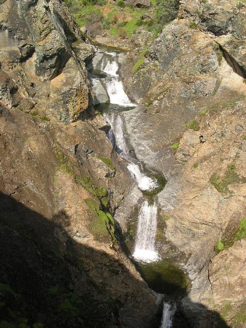
From the T at wagon Road Turn Right (South) for .2 mile and do a 180 degree turn onto Live Oak Spring Trail. Follow Live Oak Spring(stay right at the fork) for 1.1 miles then turn right at the Y and head on down to Lower Pacheco Falls about 1 mile.
From lower Pacheco Falls head back up the trail toward Wagon Road after about 200 or 300 yards park your bikes and follow a short spur on the right of the trail to a great view of the upper Pacheco Falls (see pictures).
After visiting the falls grind your way back up to Wagon Road. Continue South on Wagon road for about 4.8 miles towards Willson camp until you reach Steer Ridge Road.
Turn right almost a 180 onto Steer Ridge Road and begin your last climb of the day. Follow Steer Ridge Road for about 2.7 mile to Spike Jones. If you are not careful you will fly right by Spike Jones. It is a small single track on the right hand side of the trail as you begin to descend Steer Ridge Road. Spike Jones is a 2.4 mile roller coaster ride back down to Coit Road.
Turn left on Coit Road and head back down to Coyote Creek entrance. Cross the gate and head back down the pavement 1.8 miles to your car.


Once you get to the top of Jackson Trail where it turns into a double track, it's best to take the single track to the left called Elderberry Spring Trail. At the end of this turn right and continue uphill to Jackson Road. Then down Jackson Road and a right on Wasno Road and a left on the very fun Kelly Lake Trail single track.
Instead of going all the way down to Willson Camp and up Steer Ridge Road, take a right on Wasno Road while zooming down Wagon Road. This leads you to another single track trail called Tule Pond Trail, a fun, fun swoopy trail. At the bottom of this you have 2 choices. Left on Grizzly Gulch Trail to Serpentine Trail and right on Steer Ridge Road to Middle Steer Ridge Trail. This option comes with a price. That would be the Serpentine Trail which is a tense and tough climb. Middle Steer Ridge Trail is an amazing downhill with lots of visibility and some great single track. Probably the best single track in the whole park.
The other option is to turn right on Grizzly Gulch Trail. This is a roller coaster of a single track trail that is mostly downhill with a thrilling ending. Near the end, turn right on Spike Jones Trail and left on Coit Road and back to Hunting Hollow Parking Lot on Gilroy Hot Springs Road.* Review edited 4/6/2009
| Thank