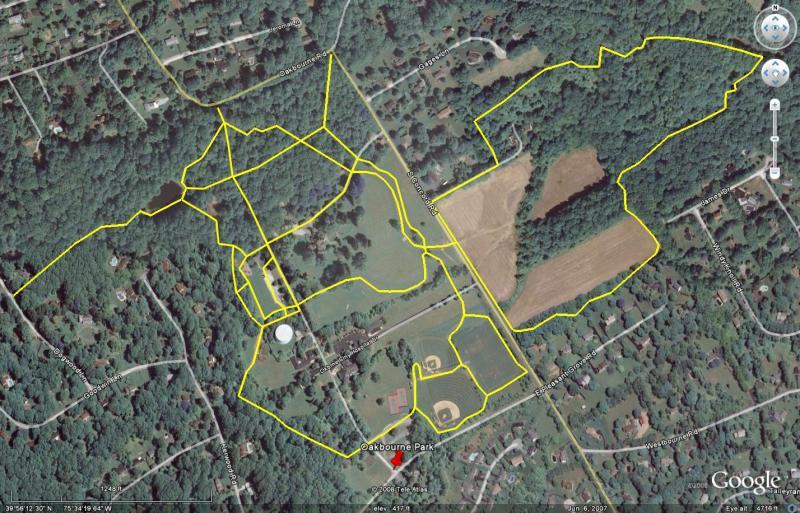
Mixed terrain. Beginner to intermediate. Would rate much higher overall if the trails were longer. Very pretty township park in nice country/suburban town. Be prepared for wildlife encounters: deer are *everywhere* in this park. You'll also get close to rabbits, groundhogs, skunks, foxes, oppossums, squirrels (seen them all), dozens of varieties of birds, turtles near the pond, and muskrats near the stream. Also, as much of this track is wooded, be prepared for the occasional downed tree, fallen branches, things buried under leaves, etc. Very low likelihood of getting lost.
Figure 8 with a 1½-mile loop in the "main park" and a 1½-mile loop "across the road," but there are a number of connecting paths and side trails. You can ride these trails several times, connecting and reconnecting from various points, before everything starts to look the same. Expect casual hikers and dog walkers on both sides of the road, many more on the main park side, but the main park also leaves much more room to work around them. Also expect sports traffic near the athletic fields some afternoons and weekends. The main park is strictly beginner level, but is still worth the ride for more seasoned riders, as the views are beautiful. Across the road is mostly single track with several intermediate quality stretches of techy terrain.
Both parking lots are on the main side of the park, so we'll start there. From the parking lot on Pleasant Grove Road, face uphill towards the tennis courts (roughly northwest). You can take off in either direction from here. If you start to the left you will make a clockwise loop. Look for the unpaved maintenance road heading into the woods. After opening up into a field, look for another entrance to the woods on your left. Quick, open, double track downhill with a few rocks, roots and plenty of loose impediments leads down to the pond. Loop around the pond if you want. Cut back into the woods on the far right side of the pond. Follow the double track through the woods up to the parking lot access road. Cut across the access road and continue on the crushed gravel path past the athletic fields back to where you started, or bear left down the hill toward South Concord Road and cross over to the second loop.
This is definitely a trail you want to ride in both directions as each offers a unique experience. Also, if you ride here in mid-summer, wild raspberries everywhere. Stop for a few minutes and enjoy a great snack. This side of the track is much more challenging than the main park side. Beginners *will* get bounced around, and I've seen a few endos here including one or two of my own.
Clockwise: Cross the road and head left. Turn right down the broken driveway keeping the cornfield on your right. Look for an opening into the woods on the left before you reach the old farmhouse at the bottom of the hill. Gradual climb through the woods with a few ups and downs and a few roots to keep things interesting. Very quick downhill with switchback hairpins at the bottom brings you to the creek bottom. Follow the single track along the creek, cross the wooden footbridge, and start the climb out of the creek bottom. Rocks, roots, ruts and some loose terrain for a few hundred yards of moderately steep climbing. A few hundred yards of rollers and easy climbing before emerging on the back side of the cornfield. Keep the corn on your right until you get back to the single track in the woods. You'll emerge at South Concord Road near where you crossed out of the main park. Cross back and ride another loop in the main park, or turn around and reverse this loop immediately.
Counterclockwise: This time keeping the corn on your left enter the woods on your right onto the single track. After crossing the back side of the cornfield, back into the woods for a nice rolling downhill, followed by a steep descent to the creek bottom with all the aforementioned rocks & roots. Mud & loose sand at the bottom. Follow the single track along the creek and climb the steep hill out of the creek bottom. It's not long (only 250-300 yards) but its's steep (over 20%) and covered with slick glass. Fun fast rollers back to the broken driveway. Right up the driveway back to South Concord Road.
I like right next to this park and it's always a relaxing fun ride. Beautiful Scenery with tons of wildlife. Riding at the park is not very difficult, but is fun for all sorts. If you're riding you may see me or you may just end up seeing my house near the pond.
| Thank