The Mount Lowe Railway is a historic railroad grade that used to transport people up the mountains to several different hotels and resorts that used to rest high up in the San Gabriels. Today the train tracks are gone, but you can still ride through an old tunnel, see old bridges, and even the ruins of some of the hotels.
The railway itself is a wide doubletrack that descends down from the Mount Wilson Observatory road all the way down to the city below. However, singletrack trails have been built around the railway, forming an excellent network of mountain bike trails!
You can ride up the railway and down the singletrack, as the guidebook recommends, or you could just get shuttled up to the trailhead at the top of the railway (on Mount Wilson Redbox Rd.) and just enjoy the delectable downhill! GPS coordinates for the top trailhead are given above (insert your address and click the “map it†function), or if you want to climb up from the bottom drive to these coordinates: 34.21482, -118.14553. If you do decide to shuttle, I recommend leaving a car down at Loma Alta Park, as it’s free (you have to buy a National Forest Adventure Pass if you park at the bottom of Mount Lowe) and there is singletrack dropping down basically right to the park (see GPS track provided).
There is a comples trail network up here with an untold number of options, but here is one route to take down.
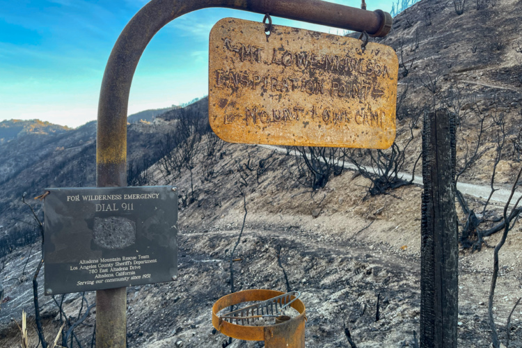
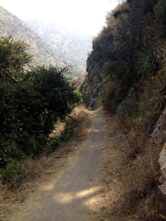
From the top, begin by descending the Mount Lowe Railway for a couple of miles. Soak in the gorgeous views, and live it up as you ride through a tunnel in the mountainside—how often do you get to do that on a mountain bike? Ignore a few of the trails branching off, but when you reach the junction with the turn off to Inspiration Point, catch the Sam Merrill trail, which parallels the road for a while and then turns downhill.
After shredding the rolling singletrack through the trees, Sam Merrill pops out into the exposed face of the mountain, turning into a technical, switchbacked descent. Look out for trail junctions, and eventually you’ll see a sign for the Sunset Trail, heading back to the Mount Lowe Railway. Turn back on yourself and begin the climb back up the hill. From here, there are other trail options that I believe drop quickly down the mountainside into town. If you live in the area, these other options are worth exploring.
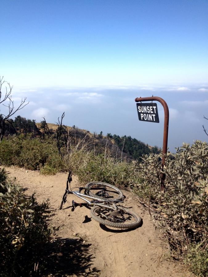
On with the recommended route: climb up the gradual grade until you reach the Mount Lowe Railway again, turn left to head down it, and take the first right onto the Sunset Trail. There’s been some awesome descending up to this point… now it’s time to really rip! The singletrack drops fast and furious, but there are numerous tight, technical switchbacks to negotiate, so watch out! The Sunset trail is an awesome singletrack ride—enjoy it!
Eventually, the Sunset trail rejoins the Mount Lowe Railway, so hang a right and continue descending. If you parked a car at the Mount Lowe trailhead, just head down the road a little ways to hook up with your ride. If you choose to take my advice and park further down the mountain at Loma Alta Park, however, hang a left off of the Mount Lowe Railway near the sign in book and map, and drop down the road next to the chain link fence.
Pick up the singletrack trail on the right that continues dropping down the mountain, and enjoy a rutted-out descent that is signficiantly more technical than most of the trails up above! Continue straight across the road to continue onto the trail, and eventually the trail drops you out right at the park—score!
If you have enough time, shuttle back up and do it again!
 | Sam Merril | 3 mi | |
 | Sunset Trail | 6 mi |


 2
2

very cool trail with stunning views on LA
| Thankeasy to ride for everybody on fullsuspension bikes
This is one of the best trails you can ride in the Mt. Lowe/Mt. Wilson range! I would like to add that you can do a short ride and just ride the lower half of the trail if you're short on time. When you see a big cylindrical silo, make a left and you will end up right at the entrance to the lower half of sunset ridge. You can also park at Millard campground and climb for 3.5 miles up the steep paved road and do all of sunset and the Millard single track. It is great and will help prepare you for the Mt. Lowe/Mt. Wilson shuttle!
| ThankComing from OC to ride this trail was great although I would say some of the sections were beyond my skill level at the time. The steepness of the mountains takes some getting used to, but a lot of fun!!
| ThankThis trail is actually divided into 3 separate trail sections, upper, middle, and lower each having its own unique characteristics.
Either of the upper two sections can be circumvented by using/switching to, the fire road (the old railway right of way)before the trailhead for that particular section.
Each section is between 2 and 3 miles long. The upper and middle sections have a high amount of exposure and some very technical sections. They are definitely advanced rider trails (Intermediate riders could ride the smoother/flowyer sections and walk the technical parts...but the exposure can present problems for an intermediate rider even when dismounted) and a full suspension bike is recommended.
The lower section, is smooth and flowy, with heavy exposure and tight switchbacks, however it is not well suited as a riding trail due to the heavy use by hikers, trail runners, and all manner of day walkers and exercisers with children and dogs.
At the bottom of the middle section, the typical MTB route is to traverse across (a 1/2 mile of generally smooth rolling 200 foot climb) to Sunset Trail.
While the lower section can be climbed; neither of the two upper sections can be ridden upwards without extensive dismounts and hike-a-bike...not to mention the trail is generally not wide enough to accommodate you and your bike when encountering a descending rider at speed.
The trailheads can be accessed by climbing the old railway ROW, or via the SCOA (Southern California Outdoor Adventures) shuttle service which departs from the Windsor Ave/Ventura Ave. parking lot on a daily schedule (check the company website for times...and be sure to be there and ready to load on time. It is advisable to make a reservation/book a seat, ahead of time, especially on weekends.)
If you are riding with tubes, it is advisable that you bring two spares, flats, and multiple flats due to rocks and pinches are a common occurrence on this trail.
It is definitely a fun, and challenging trail; one that is well worth doing, and that you will remember afterwards.
| ThankGreat ride. Many ways to ride this mountain. Mt. Wilson area has to have over 100 miles of singletrack, many loops, and a lot of ways to go up as well as down. This entire area is enough to keep you satisfied for ever. Though I don't live at the base of the Mountain as I used to, I still look forward to riding this trail whenever I am in town. If you keep going to the top of Wilson, you can go down the back into Switzer falls and back out through Aroyo Seco / Brown Mt. route which comes out behind JPL and will take you most of the day. The single track back behind Switzer and Brown Mt. is really fun with water crossings and interesting features...a lot of it in the shade and very beautiful. Feels like you're hundreds of miles from the city back there.
| ThankGreat singletrack Nice high elevation. You can hit as a loop from the gated fire road on the way to Millard Campground or on the way down from Mt Lowe, Mt Wilson. Can also continue through Millard campground and ride El Prieto.
| ThankThis trail is actually called "Sunset Ridge Trail" and is technically located in the Millard Canyon area of Altadena.
I discovered this trail through a friend who took me hiking here once. I saw a lot of tire tracks on our way up and knew this would be a fun and technical downhill. My next trip back I brought a friend who also rides and we took the fire road all the way up (such a grind!) for about 3 miles until we hit the upper trailhead. As mentioned by other reviewers, this is a downhill not to be missed in SoCal. Huge rocks, some decent drops, hairpin switchbacks with steps leading to them-if you're not careful or pick the wrong line, you're going over your handlebars.
Sunset Ridge is now our favorite trail to ride as we both live in the area. We've nicknamed the entire experience "Hammerdick Hill" because of the grueling fire road climb and exhilarating singletrack down. Oh, and be wary of hikers with dogs!
| ThankThe grind to the top is worth spinning. The network of singletracks are a mtbr's dream. Make sure you check out the echo phone and stop to read the history of the trail as you go up.
| ThankThis is intermediate? I thought sunset was much easier than this. I loved it but there was a whole lot of sketch for me.
| ThankI went to the top of the railway through the tunnel and then came back catching the mount lowe east trail then back to the road the sam merril then back to road then Sunset trail. It was pretty cool. I wish I had just gone to Sam Merril and started the descent. 10 Miles up is crazy. But worth it. I love the idea of the shuttle but I am philosophically opposed. Not for long probably. If its your first time it is hard to resist climbing to the tunnel. The climb gets easier at about 3 miles.
| ThankI would say it is more of a downhill trail. Tried riding it up but very dufficult and would take for ever to make it to the top, i ended going back to the fire road and climbed all the way up and had a good time coming down
| ThankWhat an amazing ride! No wonder it's so popular!
| ThankAwesome singletrack trail!!
| ThankGreat trail offering up some super fun singletrack! Definitely way more fun heading downhill, but could probably be ridden up for the most part as well.
| Thankgreat trail! i'm just getting started and wanted something a little more difficult. was hard to find at first with the directions. enter the forest preserve and drive up the mt maybe a 1/2 mile. the "fire gate" is a large white gate with red stripes on it to the right of the main road.
| ThankThis is an awsome trail. Defnitely rde this one.
| Thank