×

|
Rate it:
Tags:
Level: Intermediate
Length: 6 mi (9.7 km)
Surface: Singletrack
Configuration: Loop
Elevation: +1,287/ -1,287 ft
Total: 153 riders
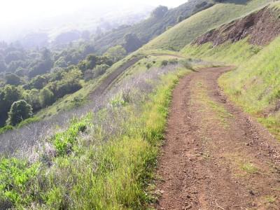
Mountain Biking Monte Bello / Rancho San Antonio
#71 of 1,008 mountain bike trails in California
Good variety of trails for the beginner/intermediate mountain biker. There are more trails
than the following loop described, just pick up a map at the trailhead/parking lot. Start off
on the Canyon Trail fireroad and veer left onto the Bella Vista Trail for some exposed
singletrack climbing on the hillside. Pass the camp site and head towards Indian Creek trail
for a long steep downhill on a fire road. Get back on Canyon trail for a short distance and
head towards White Oak trail for some creek-side singletrack through the woods. Out of the
woods, the climb continues on singletrack and can be tortuous on a hot summer day. At the
top, take a right at the intersection towards the parking lot.
First added by searsandrewj on Aug 18, 2003. Last updated Apr 30, 2020. → add an update
Before you go
- Drinking water: unknown
- Lift service: unknown
- Night riding: unknown
- Pump track: unknown
- Restrooms: unknown
- Fat bike grooming: unknown
- E-bikes allowed: unknown
- Fee required: unknown
This trail information is user-generated. Help improve this information by suggesting a correction.
Go north on 280 from San Jose, exit Page Mill Rd. Turn left, go about 7 miles into the hills
and there will be a parking lot on the left for Monte Bello Open Space. If you get to Skyline
Blvd, you have gone at least a mile too far.


It's really close to work so that's nice, it's a fairly easy ride with the climbs not being too terribly steep. It's difficult to go fast here with the brush blocking your view, last thing you'd want is your head to end up in a horses behind.
| ThankThere's one really fun descent with a bunch of jumps as u descend down this canyon, a very smooth float canyon. Later you'll have to pay for it with a very long climb though (grizzly i think?) overall a fun, relaxed ride.
| ThankMy favorite ride at Montebello is to start at the very end of Stevens Canyon Road (I don't recommend parking in the legal parking lot.. the long paved climb to gated entrance is no fun) at the gate (*technically*, you're not supposed to park here, but I've had no problems), and climb all the way up Canyon Trail. At the junction of Canyon and Indian Creek trails, I usually take Indian Creek to the top of Black Mountain, but this is a pretty hard climb that I wouldn't recommend to beginners.
The alternative (at the aforementioned junction) is to keep going on Canyon Trail, then turn off on Bella Vista trail , merge onto Old Ranch Trail, and come out on the top of Black Mountain. Enjoy the views here and take a break before the ride back down.
This is where the fun begins - although you can take Indian Creek back down to the junction, it's pretty gravel-filled, loose, (there are a few jumps), it's more fun to go back down on the singletrack (Old Ranch>Bella Vista>Canyon). This part is especially gorgeous if you are riding in the 2nd half of the day with sunset approaching.
Once you are back at the junction, the ride back down Canyon to wherever you parked is my favorite part of the place. Nonstop winding downhill trail with some sweet jumps and lots of sidewalls you can ride on.
The overall idea is to climb up Canyon Trail and ride back down it, although you can include the ride to the top of Black Mountain if you wish to do so.
Here is a nice map that will explain all the trails at Montebello:
http://www.openspace.org/preserves/maps/pr_monte_bello.pdf
note: there is currently work being done on the trail, you may run into bulldozers adding dirt or making ramps and such, but it doesn't affect the overall ride
| ThankWhile at Saratoga Gap, I descended on Grizzly Flat (Saratoga?) then connected with Canyon trail and climbed out on Lower Table Mountain and Charcoal Rd. The only thing really worthwhile about that aspect of the trip was realizing I was definitely going the wrong way on Lower Table Mountain. It looked like it would be a hoot going down rather than up. 1.2 miles of singletrack or so. Charcoal Rd. is a "one way" with bikes so it must be accessed using another route.
| ThankThe views are fantastic over looking the Bay Area! This trail is probably a bit over an intermediate rating due to a few sections that are quite narrow and very bumpy. I took my wife oout here on her new Shift R1 and she was very nervous an overly cautious on this ride but I do believe after she is more familiar with her bike she will overcome her shakiness. I'm looking forward to more exploration of this series of trails.
| ThankIf you start at the resivoir expect to climb for 6 miles (5 on the road and 1 on the trail). The climb is an awesome work out and the view is awesome. The downhill section is quite narrow at points and there are a couple off camber turns but plenty of rolling jumps to hit. This trail is an good 22 mile loop if done right.
| ThankThis might become a regular ride for me. We've just had a huge amount of rain dumped on us, with more to come. The tail end of the ride was shut down for this reason. It's mostly open air, though, so when the sun comes back it should dry out fairly quickly. Nice climb early on. Fun bombing run down the fire road as your reward. More interesting climb towards the end (wider path, but in the woods, with roots and mud to contend with occasionally). Beautiful views.
| ThankAMAZING location, many trails, got lost first time but very glad I did. lots of variety, forested areas, open fields, very difficult climbs but rewarding downhills.
| ThankIt is a little too short if you only have an hour it is good but pretty remote for that. It is a fun trail and very hard to stay under the 15mph speed limit. Nothing technical or I would rate it higher. Nice scenery.
| ThankOh, I miss this ride. I wasn't in the best shape when I used to ride this one so I always got cramps. I liked starting on Stevens Canyon Rd. and riding it into the park. There's a long, hard climb up Charcoal Rd. (God help you if it's hot out). Then you can cross Skyline Dr. and take the trails on the other side of the road. Nice view here and a good spot to refuel. Come out on Skyline a few miles down the road and take Grizzly Flats back down toward Stevens Canyon. Good stream crossings, too.
| Thank