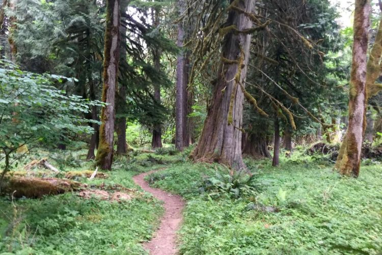
The trail starts on the far side of the bridge from the parking lot and goes up the river. The section going down the river from here is a barrier free trail. The trail is described from lower trailhead going east. The trail parallels the river, first winding along the river bank like a gentle roller coaster. This part of the trail is in great shape and fun as well. In just past 3 miles you arrive at Bolt Camp. There is a cabin here maintained by a forest service worker in his spare time. Just past Bolt Cabin there is a small landslide and a larger one a little distance up. Hike a bike can be done over the slides if careful. In a couple more miles the trail climbs up to the bluff and winds along above the river. The upper section of the trail goes past the Lower Falls Campground. This trail gains more elevation than it looks like on the map but it's worth it. Considered by most as one of the best low elevation trails in the state. This trail has become famous not only from word of mouth but has been featured in several magazines and calendars. Motorized use is not allowed on this trail. It is part of the C to C Route. The trail goes along high cliffs, especially in the falls area. The beauty of the area is awesome and so are the drop offs. Use extreme caution, along all areas next to the river. There are some areas worth walking where the trail is narrow. See web site at ebiketrails.com


 6
6
Solidly Intermediate trail with some pumpy climbs and a few technically challenging steep sections that allowed my dog to catch up/rest up until the next downhill. Definitely a fun trail to keep coming back to! Our conditions were perfect - if a little wet after a light rain. Certain sections were vulnerable to wash out when we rode but seemed well maintained. Great ride!
| ThankI rode this trail a few days ago. I started at the trailhead mentioned above and rode for several miles along it but didn't go the distance because it was getting dark. I didn't encounter any other people on the trail. The trail was really smooth with few very technical sections. There were some sharp climbs but they were manageable. I enjoyed the views of the Lewis River along the way. The only reason I didn't give this five stars is because there weren't truly spectacular views, but I'd have to climb more hilly terrain for those! I'll definitely be visiting this trail again when I have more time to explore it.
| ThankScenic but tough trail. Several creek crossings, climbs and descents that require multiple athletic moves to negotiate. Then there are a couple of long climbs that require stout legs and lungs. Otherwise it is a nice trip through the forest along a beautiful River with fantastic waterfalls on the upper end.
| ThankA fun, lengthy trail; however, there were parts of this trail that were extremely difficult. When you get back about 5 miles or so, there were steep, rocky ascents and a couple of trees across the trail. Just saying that if you read the trail descriptions, they make it sound like 20 miles of smooth singletrack--not the case. Yes, most of the trail is fun, flowing and scenic, but there are those few sections that will kick the butt of any 50 year-old fat-tire rider. Bring plenty of water and a few energy bars! Tight spokes!
| ThankBeautiful scenery the whole way!! I rode from the lower parking area all the way out and back. Really nice trail for the XC riders, if you're looking for obstacles and jumps you won't find them here. The Forest Service does a great job maintaining the trail and there are nice bridges accross all of the water crossings. enjoy!!
| ThankThis was a really cool ride along the river. I too saw the elk! The water falls and the streams flowing over the trail are awesome. As far as I could tell not Alot of people ride here so you kind of have the whole place to your self which is nice.
| ThankRode from Lower Falls Campground as an out and back. Great scenery along the river with a lot of short steep climbs on the way out that are much easier on the way back. I found the ride a bit slow for how non-technical the trail is but still fun. Had two challenging stream crossings (walking across fallen trees) and encountered a few downed trees. All in all a great ride. Didn't see another person.* Review edited 6/4/2011
| ThankThis could be my favorite trail in Washington, right up there with Galbrath mountain in Bellingham. There isn't as many stunt setups with wood plank skinnies or jumps, but there are some natural technical obstacles and difficult, rooty downhill sections to manipulate. There are also some very narrow singletrack sections at a cliff side which adds some nice adrenaline rushes.
Mostly though what makes this trail so great and unique is its gorgeous scenery right next to Lewis River. The whole ride you elevate over the lake and you get a gorgeous view at many turns. HIghly recommended!
| ThankGreat scenery. Sweet Singletrack. Epic Ride. This trail should have all these labels, I was able to ride the first 6 miles in and then had to back out due to the late hour today, a fantastic ride I cant wait to do the whole thing. I found all the other reviews had said to be true and the areas over the landslides had been worked and were ride-able, I did run across about 4 downed trees in the 6 miles but that isn’t rare in Washington.
| ThankKeep your eyes open when riding this area, I spotted two bald eagles and spooked up a herd of about 20 Elk on my way back out.
This is an awesome trail---definitely one of the best in the area! Very nice singletrack. The first portion is relatively flat with little ups and downs; super fun for just cruising.
Then the trail gets more technical with steeper ascents/descents and several creek crossings. There is a little portion of the trail where you must do some hike-a-bike to get around a portion of the trail wiped out by a landslide.
But it's all worth it when you reach the incredible view at Lower Falls. If you want, you can continue up the trail another couple of miles to Middle and Upper Falls.
Overall, this trail offers an addicting mix of smooth singletrack, technical sections, and gorgeous natural beauty to keep one happy the whole ride.
| Thank