×

|
Rate it:
Tags:
Level: Advanced
Length: 7 mi (11.3 km)
Surface: Singletrack
Configuration: Loop
Elevation: +502/ -488 ft
Total: 41 riders
Mountain Biking Jesusita
#170 of 1,015 mountain bike trails in California
One of the few rides accessible from town by bike. Great pre- or post-work ride. Local club - SBMTV.org - hosts Wednesday night rides. Can bust out loop in under 2 hours. Good long climbs with put-your-head-down-and-mash stretches punctuated by technical featured sections. Great views of SB and Channel Islands from Inspiration Point. Downhill from there, armor recommended. Top is very loose and scratchy but all rideable. Great stretches of buff singletrack and switchbacks down to creek. Creek trail is typical SB frontcountry featuring a lot of smoothed boulders, big drops, stairs, off-camber, but - again - almost all rideable.
Please anticipate THERE WILL BE OTHER TRAIL USERS, including horses. Please be respectful and yield to all. Also consider wearing bells on the downhills. Jesusita is one of the last frontcountry trails open to bikes. We really don't want to loose this one. Be cool and spread the stoke!
First added by rsmarg on Sep 6, 2008. Last updated May 11, 2020. → add an update
Before you go
- Drinking water: unknown
- Lift service: unknown
- Night riding: unknown
- Pump track: unknown
- Restrooms: unknown
- Fat bike grooming: unknown
- E-bikes allowed: unknown
- Fee required: unknown
This trail information is user-generated. Help improve this information by suggesting a correction.
Park at Rocky Nook Park behind the mission. Ride to back of lot, follow singletrack uphill to fire station. At fire station, cross Foothill Rd. and continue up Mission Dr.. About 1/2 mile at fork, go left up Gibralter Rd. In about 1mile look for cars usually parked at ride, at fork go right to gate. Go around gate and continue up paved service road. Take till pavement ends. Continue straight up dirt about 200 feet. Look for trail on left (sometimes signed). Trail is straightforward until large creek crossing. At other side of creek stay left. Take all the way to top, continue across service road. This is Inspiration Point, where downhill begins. Continue for downhill, often paralelling service road. Continue under power lines and begin looking for singletrack trail on right. Take and descend to creek bed. Continue along creek till it ends at pavement with picnic area. Take paved road couple hundred feet where trail continues on left. Take all the way till ends at wastewater treatment plant. Ride paved road back to Foothill. At Foothilll go left back to fire station and take trail back to parking lot.


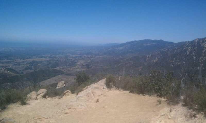

While the riding in Santa Barbara may be limited, Jesusita is definitely worth the effort. It's a steep climb, but one that intermediate riders can spin up. The descent requires some skill. Intermediates will likely be in over their heads (if not over their bars) once the real meat of the descent begins. There are very rocky sections interspersed with speedy bits of trail. The unsuspecting, and unprepared could like life in Jesusita canyon tough.
| ThankFun close to town up and back single track. Start from town in the multiple entry points in the neighborhood parks and ride all the way to inspiration point for great views. Most the climb is rideable you may have to hike a bike over 3 or 4 river beds or switchbacks on the upper climb unless you are a advanced rider. Fast flowy single track with some technical rock gardens. Use a bell on this trail lots of hikers. Highly reccomend this ride one of the best around SB.
| ThankThis can be ridden as an out and back or as a loop with the tunnel trail. Both options will feature some hike-a-bike, but coming from tunnels will feature less hiking. You will have to get back to your car though. Like most trails on this area, you'll have some switchbacks near the top (after the small fire road section). Then you'll hit the rock gardens as you make your way down the trail. Up by Inspiration Point there is a nice little DH section.
| ThankBest single track in the front country. make the loop up Tunnel/Inspiration point trail and down the Jesusita and ride Foothill Rd back. First part is usually crowded on weekend but Jesusita is less traveled. Give it 2 hours plus some time to soak in the views at Inspiration point.
| Thank