×

|
Rate it:
Tags:
Level: Expert
Length: 6 mi (9.7 km)
Surface: Singletrack
Configuration: Out & Back
Elevation: -
Total: 4 riders
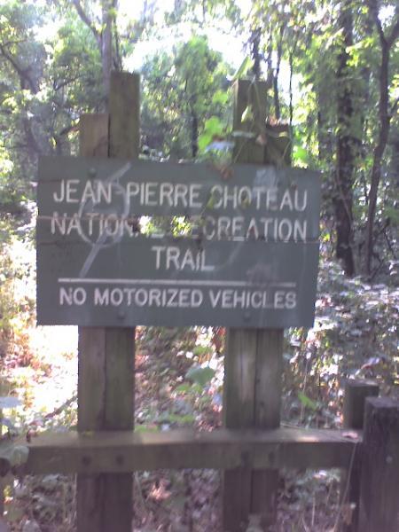
Mountain Biking Jean-pierre Chouteau Trail
#51 of 68 mountain bike trails in Oklahoma
This is the biking portion of the Jean-Pierre Chouteau Trail that runs from Okay, OK to Ft. Gibson, OK, near Muskogee, OK. This easy to moderate, multiuse trail follows along the Verdigris River. Can be muddy. Pa** Port of Muskogee.
The entire Jean-Pierre Chouteau Trail is located alongside the MKARNS from a point near Ft. Gibson, OK, is 60 miles long, has a total of 15 bridges spanning streams and six public use areas with camping and picnicking facilities, and is on the National Register of Trails.
First added by dauw on Jul 28, 2005. Last updated Nov 30, 2020. → add an update
Before you go
- Drinking water: no
- Lift service: no
- Night riding: yes
- Pump track: no
- Restrooms: yes
- Fat bike grooming: no
- E-bikes allowed: yes
- Fee required: no
This trail information is user-generated. Help improve this information by suggesting a correction.
Pick up the trail in Okay, Oklahoma, SE of town off of HWY 16. Or, hit the southeastern trailhead in River Park, Ft. Gibson, OK.


First 1.5 miles are in great shape.
| ThankHard to find. Not taken care of. I saw several "no trespassing" signs and "Do Not Enter...Leased Land" signs.
| ThankI am trying to get this trail back up to where it ought to be. The Corps has taken the trail back over (it's no long a National Recreation Trail) and is willing to work with me. If you wish to help, please contact me at [email protected].
| ThankLast time I biked this trail from the west, you started on the north side of the river at US 66, followed the road under the turnpike to the trail, and after a while, swam across where a bridge used to be.* Review edited 6/3/2009
| ThankImpassable @ Ft Gibson trailhead because extremely overgrown/neglected. Couldn't get more than 100 yds from trailhead.
| ThankThe trail head at Ft Gibson is unpassable with thick growth and no definite trail. I tarted on a bike and was only able to go 1/4 mile before having to cross a downed tree, shortly thereafter tall cane
| ThankMore information about the JEAN PIERRE CHOUTEAU NATIONAL RECREATION TRAIL is at www.geocities.com/graystrickland.
| Thank