×

|
Rate it:
Tags:
Level: Intermediate
Length: 10 mi (16.1 km)
Surface: Singletrack
Configuration: Network
Elevation: -
Total: 18 riders
Mountain Biking Glacier
#112 of 392 mountain bike trails in Wisconsin
Trail Name: Glacier Trail
Distance: 10 miles
Difficulty: Intermediate
Trail Type: 62% single track, 35% two track, 3% gravel road
Description:
Talk about variety and scenic views! Another great hammer route or simply a terrific tour
First added by trnelson on Nov 20, 2004. Last updated Apr 30, 2020. → add an update
Before you go
- Drinking water: unknown
- Lift service: unknown
- Night riding: unknown
- Pump track: unknown
- Restrooms: unknown
- Fat bike grooming: unknown
- E-bikes allowed: unknown
- Fee required: unknown
This trail information is user-generated. Help improve this information by suggesting a correction.
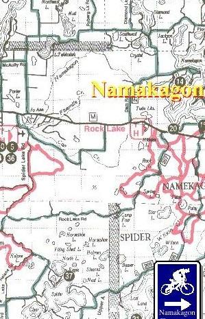
From Cable Wi head West on County Rd M approx 7 miles until you reach Rock Lake Parking Area, on right hand side of road. Marked with a nice National Forest Sign.

Beginner frindly trail. There are no huge climbs. Fast rolling trail
| ThankThis is a beginner-friendly trail, though beginners will want to ride it as an out and back from the Wilson Lake trailhead. Also used as a connector as part of the Rock Lake Epic loop.
| Thank