×

|
Rate it:
Tags:
Level: Intermediate
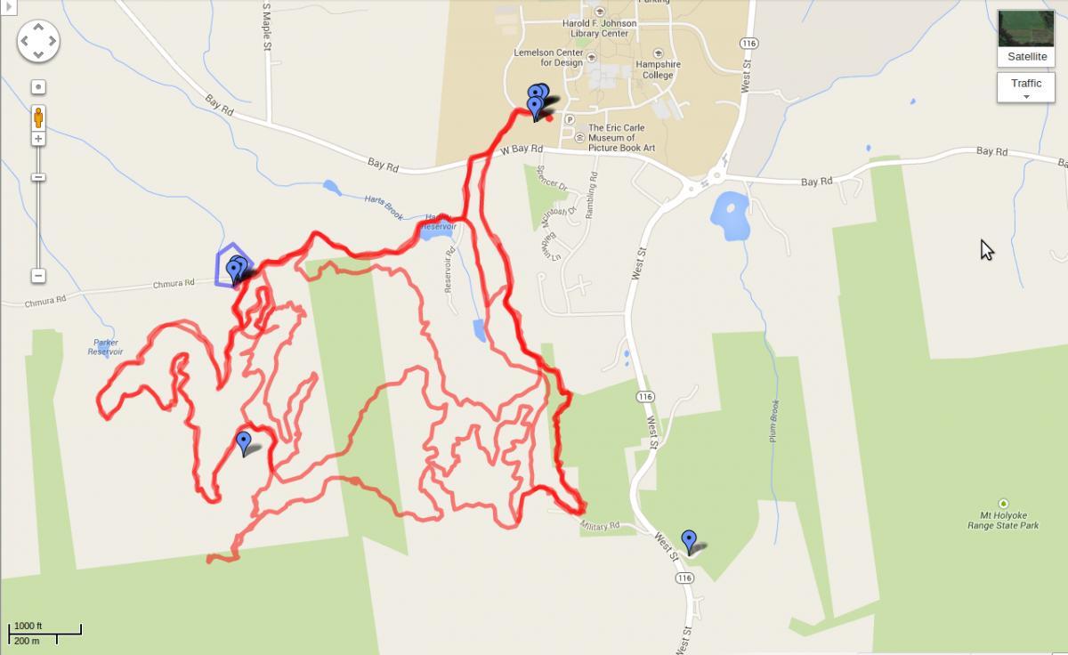
Length: 12 mi (19.3 km)
Surface: Singletrack
Configuration: Network
Elevation: +684/ -705 ft
Total: 88 riders
Mountain Biking Earl's Trails
#10 of 223 mountain bike trails in Massachusetts
Trail network is a maze of excellent flowy, suprisingly smooth singletrack for
New England. Plenty of climbing, best suggestion is to enter at the Notch
Visitor Center and take a right at the first trail fork for a nice decent. Then,
explore.
Added Bonus: Batchelor St. Trails are just to the east, so plenty of riding
here.
First added by kippcarlisle on Jan 19, 2012. Last updated May 11, 2020. → add an update
Before you go
- Drinking water: unknown
- Lift service: unknown
- Night riding: unknown
- Pump track: unknown
- Restrooms: unknown
- Fat bike grooming: unknown
- E-bikes allowed: unknown
- Fee required: unknown
This trail information is user-generated. Help improve this information by suggesting a correction.
Park at the Notch Visitor's Center in Mt Holyoke Range State Park, on the
eastern side of MA 116 (West St). Trailhead is diagonally across the street at
the far end of Military Rd, on the right at the gate.
Alternative trailheads off of CHmura and Reservior Roads.


Love the place!
| ThankFirst time here. Luckily found a local to guide me. Shout out to Carl. Trails are a nice mix of up and down with nothing that is too crazy. Easy to get lost if you're not familiar.
| ThankNew to trail riding, but been here three times and love it. Well maintained trails with good flow and some challenges. Great workout!
| ThankThese trails are a ton of fun. Great flow, some longer climbs and a few screaming descents. These are not the most technical trails in the area but that adds to the appeal. Go here if you want to ride fast, and most importantly keep riding. The only thing limiting you here is your fitness.
| ThankThese trails are a ton of fun. Great flow, some longer climbs and a few screaming descents. These are not the most technical trails in the area but that adds to the appeal. Go here if you want to ride fast, and most importantly keep riding. The only thing limiting you here is your fitness.
| ThankThe best flow in western ma. It has great climbs and fast descents. Many people ride here.
| ThankA fantastic collection of flowy trails that have enough climbing and descending to keep the heart rate up for most of the day. You'll get lost but just go with it, you'll figure it out soon enough
| ThankI agree....surpisingly fun trails. Will definitely hit it again when I do my I91 VT-CT trips.
| ThankExcellent smooth single-track with well-thought-out contours. Fun, with a moderate amount of climbing. Park at the visitors center and then cross the street to pick up the trail - note that the bike trail starts at the same spot as the hiker-only trail but heads off to the right immediately.
| ThankYou need to stop at the visitor center and get a map of the trails before you start your ride. The best trail is the "Roller Coaster" Trail. Some spots are techincal, but well worth the experience
| ThankLast time I was there October 7th or so. All the trails were covered in very pretty yellow leafs. However it Made it difficult to navigate. Be careful.
| ThankJust walked this for the first time today. Going back tomorrow to ride, Can't wait! This trail set looks great!
| ThankWill post a ride review soon. Also some pics.
Good trail head. trails were maintained and smooth, however the abundance was confusing ( there is so many trails, finding the way UP the mountain is more difficult than the climb). the technical trail is fun- not as fast as i would like- but alot of work was put into it.
| ThankUsed to ride here all the time back in the day. Good cross country trails. Nothin too tech but real nice fire road and some singletrack. Check the map and plan your route and it's even more fun.
| Thank