The first five and a half miles of this route follow the Colorado Trail. Find the signs that show you to the trail and head north for about a mile where the trail crosses the road (it's now called Deckers Road - either way, it's CR126).
Cross the road and go about 4.5 miles until you get to road 538. Pay Close Attention here. The Colorado Trail continues across the road, but don't follow it. Turn left on the forest road and go just under a tenth of a mile and look for the trail on your right. The trail, being seldom used, is a little hard to see. Look for a sign that says "No Motor Vehicles" and a little gap in the gate. This is the trail. Go up about ¾ of a mile and reach the rocks.
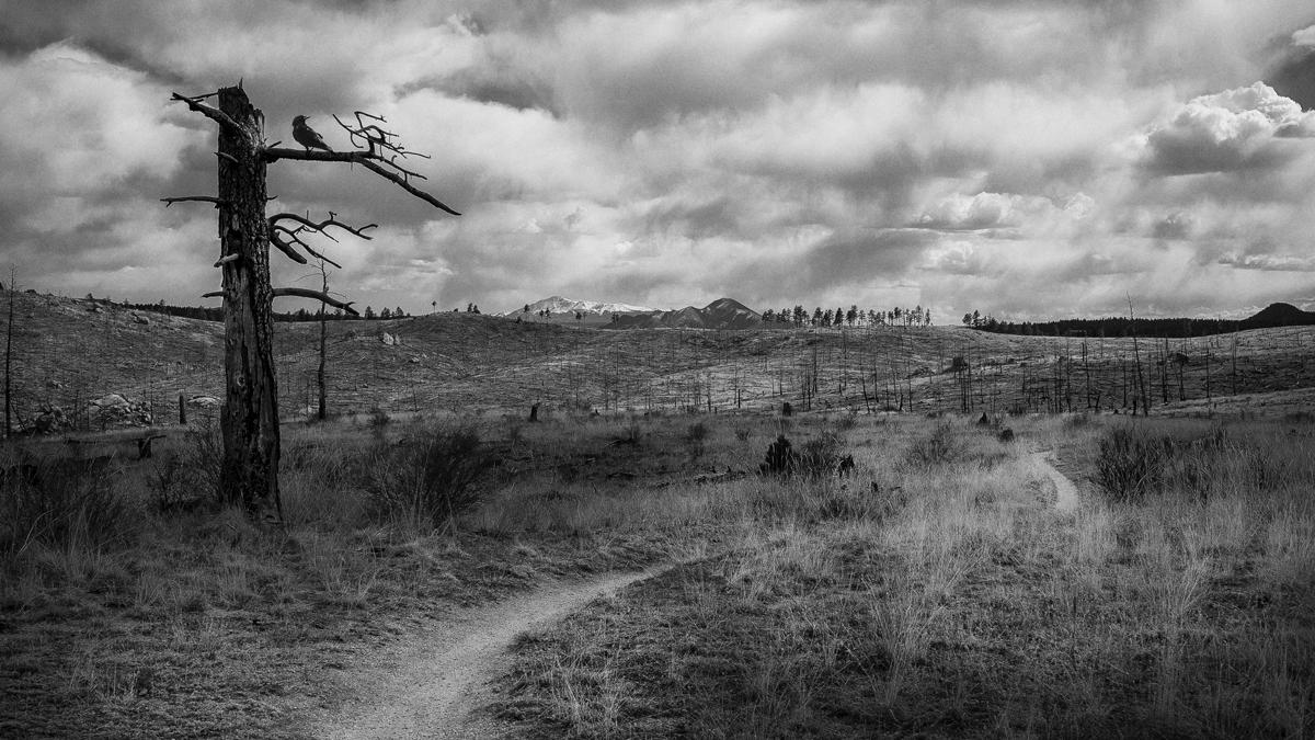
Chair Rocks has got to be one of the great unsung heros of Front Range mountain biking. The tread is mostly smooth, if not a little loose in spots, the hills are gentle and the singletrack is seemingly endless as it winds its way in and out of the Buffalo Creek burn area, around, near and right up into some really groovy rock formations. There's great wildlife watching, flowers, expansive vistas, breathtaking valleys and hardly another human soul on the trail.
If you bring a camera, plan on adding at least an additional hour to your ride time and bring lots of film/card space. Also, bring a pair of walking shoes. You will want to walk around the rocks where your cleats can do a lot of damage. Awesome views of Raleigh Peak to the east, Long Scraggy Peak to the south and once you get up to the Chair Rocks, Banner Peak and the Cathedral Spires to the north.


You might call Chair Rocks a nice pleasurable ride. It's a good ride on a day you don't want to be hammering gnar or conquering massive climbs. Instead of starting from the parking area at the beginning of the 550 Road, you can start a little further west/down the 550 Road where the CT crosses the road. This adds a 1/2 mile of nice single track each way. Also, I recommend avoiding the CT from the same parking area (at the beginning of the 550 Road) to CR 126. That portion of the CT is a piece of junk in terms of trail -- a sandy forest road. Instead, use the Buffalo Burn trail that basically parallels this part of the CT (see the Chair Rocks trail map). Buffalo Burn is a nice twisty single track and adds about a mile each way. Finally, the ride back from the Chair Rocks formation south to CR 126 is a twisty playful stretch of trail of about 4.5 miles. The elevation basically works in your favor much of the way in this direction, and you ride with a lot of the momentum.
| ThankDefinitely one of my favorite rides. It's about a 6 mile ride from Little Scraggy Trail Head to Chair Rocks. No insane climbs, but you still get some great up and down hill stretches. The trail is in good shape and the views are spectacular.
| ThankVery fun trail. Lots of rolling hills. Will bring all of my flatland friends here to give them a taste.
| ThankMy wife just started riding, so we have been searching out the best beginer trails on the Front Range- AND THIS IS IT! Trail is beginer level at all points, no one hill is too much for a begining rider, yet by time you put it all together they will feel like they accomplished something. Absolutely beautiful, even for Colorado, trail is in great shape. Only problem is that this is no longer a hidden gem. Put this one on your list, it is Buff Creek for beginers. It ends at the Chair Rocks and that is a special place.
| ThankRode this trail today for the first time this year. the trail was in good shape, seemed like there was a little more loose stuff out there than there has been the previous years. all in all still a great trail to get a couple hour ride in. If you dont want to pay to park in the lot on the 550 road. you can use the pull off on the east side of the road just past the new fire station. Stop in at Zokas in downtown Pine, or at Crossroads at the light in Pine Junction. Crossroads has $1 PBR's From 3 to 6 on Sundays.
| ThankLoved this ride. This was my first mountain biking experience and for me it wasn't a beginner trek, it was intermediate. Overall it was a super fun and challenging ride. On our way home we ate lunch at CrossRoads Pub & Grill which was quite entertaining with a band on the porch. A great day trip! *Note: Make sure to bring $6 for parking lot fee*
| ThankThis trail is in buffalo creek, not in conifer.* Review edited 8/28/2012
| ThankThis is an AWESOME ride !!!! You can make this as hard or as easy as you want. Warning do not be fooled !!!! There are many hazards that will hurt you if you think you are on a Sunday cruise. The conditions change from sand and pebbles back to hard pack and rock. There are many areas where 14" tall stumps are in the grass along the trail, just waiting for you to not be paying attention. The reward is that the experience is well worth any time it took to drive there. The fact that you may only see 2 people the whole day is a shame because this is an awesome place to work on your cardio training. The views are almost unequaled any where on the front range. I made this a 25 mile day taking in some of the Colorado Trail north of Raleigh Rd (538 road). Spend the day, take in the beauty of Gods creation and have fun,,,
| ThankThis is a great trail and a great ride. Nothing technical and no real difficult climbs and lots of single-track make this a fun ride for just about anyone. Although I might rate this as intermediate just for the workout that you can get. The majority of the ride is on the CO Trail which is open, twisting and exposed from CR126 to 538 road. From the Little Scraggy TH (main parking area) I took the Buffalo Burn trail as an option over that part of the CO Trail. Buffalo Burn is tight little flowing single-track through trees and some of the burn area that would be ideal for beginners. This drops you out back onto the CO Trail near CR126 where you cross the road and turns back into single-track. The CO Trail from the TH to CR126 is a VERY wide (8ft) smooth road/trail making Buffalo Burn an excellent alternative in both directions. It's about a 4.5 mile ride on the CO Trail from CR126 to where the trail crosses the 538 road. From there the trail up to Chair Rocks is slightly steeper but is only about a .5 mile trip to the rocks. Your reward will be incredible 360 degree views and a fast mostly downhill ride back to the parking areas. My computer said this was right at a 15 mile ride with less than a 2 hour ride time (at a very moderate pace). Taking the Buffalo Burn trail ads about 1.5 miles to this trip in either direction but is the route I would recommend.* Review edited 10/19/2010* Review edited 10/19/2010
| ThankThis trail is USDA certified pure cross-country. It has great flow, long sight lines, and great views of Mt. Evans & Bierstadt on the way out and Pikes Peak on the way back, yet no major climbs or descents, and no major technical sections. With the exception of the scenery this is the exact type of trail you’d find in the Vegas/Phoenix/Albuquerque desert areas. As such its great for beginners, yet more advanced riders can push it hard to get a great workout and even get a couple scares. That’s because the tread – like all trails in the Buff Creek area – is sandy and pebbley. At speed this stuff can act like ball bearings. In addition, while the trail generally follows the contour there are enough sharp turns lurking in the runouts of the woops to keep you on your toes.
The trail is perfect for hardtails, rigids, singlespeeds, fixies, and night riding. In fact, I’d say its actually better on a hardtail since you’re pedaling and pumping most of the time, even on descents, so no need to deal with the bounce of a full springer.
My only problem with this trail is the distance it takes to get there. Its a solid 50 minutes from Evergreen and 20 minutes from Pine Junction. If you're an advanced or fit rider its probably a good idea to plan on hitting some other trails in the area to make it worth the drive time. If you're a beginner its worth it if you plan to check out some of the eateries or bars in the Buff Creek, Pine, Conifer areas. Probably not worth a trip just to ride this trail by itself.
Couple of suggestions for directions. 1) I don’t recommend parking at the National Forest Service’s Pine Trailhead unless you intend to ride the other trails out of there, too. Not only do you have to pay to park there but the ride to the main Chair Rocks trail is on service road and downhill, which means you’re climbing to get back to your car. Instead there’s a turnout off Deckers just before the NFS parking area. It’s on the west side of Deckers Rd. exactly 2.9 miles from the ranger station. (If you’re coming from the south its just past the lefthand turnoff for the NFS area on your left. Cross the road from there for the trail. 2) On the trail at the 4.5 mile mark, when you get to the junction of Raleigh Pk. Rd and Lion Cave you want to go hard left on Raleigh Pk., not Lion Cave. (Both are to the left of the Colorado Trail). Then proceed as noted 1/10th mile to the trail to Chair Rocks on the right.
I give this a 4-star because its a "Classic". Better than a 3-star "Good" but not a 5-star "Epic."
| ThankI just rode this trial and it was a great single track. It is definitely a beginner when it comes to the technical aspect but it is not so much a beginner trail when it comes to the physical aspect. It is a steady climb to chair rocks and it kicked my butt!!! Loved the trail and can’t wait to do it again. When you come from the south take Hwy 67 North and stay left at Deckers. After you pass the Kelsey campground, you have about another mile or so and then make a left at the 550 road (its marked well). The parking lot will then be on your right. Also there is a $5 parking fee for the parking lot which I don’t think was mentioned in previous information.
| ThankGood beginner trail in the Buffalo Creek neighborhood. If you start from the parking lot it starts downhill then it is a series of mellow ups and downs. So the finish is kind of a burner but overall a great beginner trail with nice scenery. We rode it at the end of November and only saw traces of snow. Thus making it a good late season ride at somewhat higher elevation. * Review edited 11/24/2008
| ThankThis is a fun, underappreciated trail, I've had several great days of riding here. It's a nice, steady climb up to the Chair Rocks, and then a fun downhill coming back. Plus, you can take a newbie to ride it without getting them discouraged.
Overall, a blast to ride, too bad more people don't know about it.
| Thank