×

|
Rate it:
Tags:
Level: Intermediate
Length: 13 mi (20.9 km)
Surface: Singletrack
Configuration: Loop
Elevation: +1,897/ -2,461 ft
Total: 27 riders
Mountain Biking Bullards Barr Trail
#114 of 1,015 mountain bike trails in California
Yuba Expidition has maps. Head East up old Camptonvile road. Trailers, dags, rusted cars and over the top. nice downhill to cool down. On the flat there is trail head north side. fast down hill(rips) at all trail weys stay north. Until overlook and Marysville road. Head East Along north side of road and watch for trail. It will cross road once then back.
First added by Juan_Gear on Jun 16, 2005. Last updated Apr 30, 2020. → add an update
Before you go
- Drinking water: unknown
- Lift service: unknown
- Night riding: unknown
- Pump track: unknown
- Restrooms: unknown
- Fat bike grooming: unknown
- E-bikes allowed: unknown
- Fee required: unknown
This trail information is user-generated. Help improve this information by suggesting a correction.
Hwy 49 to Downiville from Nevada City. Left on Marysville road Park at bar/store.


This is the best trail I've been on! Single track that runs above a beautiful turquoise lake. We ride and then stop to do some swimming in the 75 water. Trail keeps you on your toes, steep drop offs on the left going out! Wonderful day trip in the summer!
| ThankTrail head is marked in the parking lot off of Marysville Rd. Head down access road towards lake and you will see trail narrowing and headed along the lake (lake is on your left). Extremely shaded single track follows lake with pine and leaf covered trail. Very quiet great views. Trail gets less manicured around mile 7 but continues along lake for 9 miles. At mile 9 you hit just a wicked switchback climb away from Lake straight uphill for just over a mile. Cross over Marysville Road and parallel road for a mile before you cross back over and hit some more nice single track with several turn offs that can take you back to the lake in steep technical downhill. Fun ride, trail could use some work but it's still a great trail.
| ThankEasy rollers entire trail and 99% in shade. Easy except must pay attention to some rocks along the way, follows contours of bullards bar lake and is not busy.
| ThankGetting There:
From Auburn- Hwy 49 North, Left (west) on Marysville Road, right into the overlook parking lot.
From Marysville- Hwy 20 East, Left on Marysville Rd., Right on Marysville Rd. at Willow Glen Rd which the road turns into if you keep going straight. Head East over the dam and turn left into the overlook parking lot.
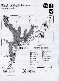
Long Route: Starting from the overlook parking lot turn left and head East on Marysville Rd, look for the single track (8 ball trail) at the entrance to the School House Camp Ground as you turn left into the campground the trail is on your right head east on the trail which runs between Marysville Rd and the campground. Stay left, close to the campsites or you will shoot back out to the road. Continue on the trail as you cross Dark Day Rd heading east. Nice climb in this section. The 8 ball trail ends at the old weigh scales. Head east down to Marysville Rd. Find the single track across the Rd and head east paralleling the road. Eventually you end up near Rainbow Market which is on Old Camptonville road and a good place to stop for a break. Head up Old Camptonville Rd. Once you pass all the c*** dumped on the road including a trailer grave yard and a collection of shot up cars you top out. The Bullards Bar Trail Head will be on the left about Ω a mile down the road. Watch for the ATV trail next to the single track on your left itís easy to miss. There is a Bullards Bar Trail Head Marker here. (If you are not in a hurry and want some warm grub in the middle of your ride, pass the trail head continue on Old Camptonville Road which takes you out to Hwy 49 take a right on 49, take the first left to go into Camptonville for a bite to eat at Burgey Daveís. Good food, cold beer on tap and mountain bike friendly people). From the Bullards Bar Trail Head, time for some downhill, lots of great single track rolling along the Bullards Bar Reservoir. Technical sections and beautiful scenery. As you head west you will pass the Rebel Ridge Trail and the 7 Ball Trail on your left. Both are marked and both are fun to come down if you donít have the time or energy to do the long loop. Eventually you pop out at the dark Day Boat launch continue straight across and look for the single track which climbs up to the day use picnic area take a right on the Rd down to the day use area with fire pits and picnic tables. Bullards Bar trail picks up again on the left before you go down to the tables. As you ride west you will pass the School House trail on your left and eventually come to a cement road, from here head up the road to the overlook. The ride is about 21 Ω miles when you finish.
Additional Loops:
| ThankThis is a great area to ride. You have multiple loop options. Dropping down the 7 ball trail is definitely the best downhill trail. The 7 ball is on the left where the 8 ball trail ends. You can also drop down the rebel ridge trail which is a good downhill and gives you a lot more single track along the lake than the 7 ball trail. The rebel ridge trail head is just before Rainbow Market easy to find as you ride east on Marysville Road. You can also start the ride at the School House campground loop whatever option you want and climb up the School House trail back to the campground.
Terrific fun once you are lakeside. Great single track that is never ending. Beautiful scenery and not too technical. Can be very fast so keep your eyes on the trail, one misstep and it could be hazardous.
| ThankStrong riders needed for this. Lots of naturals for some air on the drop in. after that lots twisting and turning with rollers all the way
| Thank