The 1900 foot downhill is very rocky and rooty with plenty of waterbars. Very fun and worth the climb!
The Clawhammer Route: This ride features Black Mountain. It's an amazing ride, especially if you like technical singletrack. It's a tough (mostly gravel road) climb for over 7 miles, the last 1.5 of which is mostly pushing (unless you've got crazy technical skills). But it is worth it for the amazing cliff-top view from Clawhammer mountain.
The route:
Park at the ranger station. Turn right onto the main road (US 276).
Mile 0.7 Turn right onto gravel road. FS 477
Mile 2.4 Horse stables. Turn Right (behind stables) up Clawhammer Rd
Mile 3.5 Maxwell Cove rd enters from right. Stay left on Clawhammer
Mile 6.8 5-way trail junction. Turn hard right onto Black Mountain Trail.
(this is where most of us will have to push)
Mile 8.0 Awesome cliff-top view. Elevation is ~4200 ft. You cross two summits
during this part of the ride (Clawhammer and Black Mountain).
After the second summit, the fun downhill finally starts!
Mile 8.6 Turkey Pen Gap enters from left. Stay on Black Mountain (white blaze)
Mile 9.6 Another 5-way junction with trails and old roads. Stay straight on
Black Mountain Trail (look for white dot because there wasn't a sign
here)
***ALTERNATE ROUTE: if you're tired of the technical stuff, turn right
here instead (Maxwell Cove Road). This is a good gravel downhill but
WATCH FOR HORSES! It will run back into Clawhammer rd. Turn left
back down to the stables. ***
Mile 11.0 Thrift Cove Trail enters from left. Stay on Black Mountain Trail.
Mile 12.1 Mountains to Sea exits left. Stay right on Black Mountain Trail.
Mile 12.2 Thrift Cove Trail enters from left again. Stay Right.
Mile 12.5 Turn right on main road. US 276. Pass work station
Mile 12.8 Turn right and finish at Ranger station.


 17
17

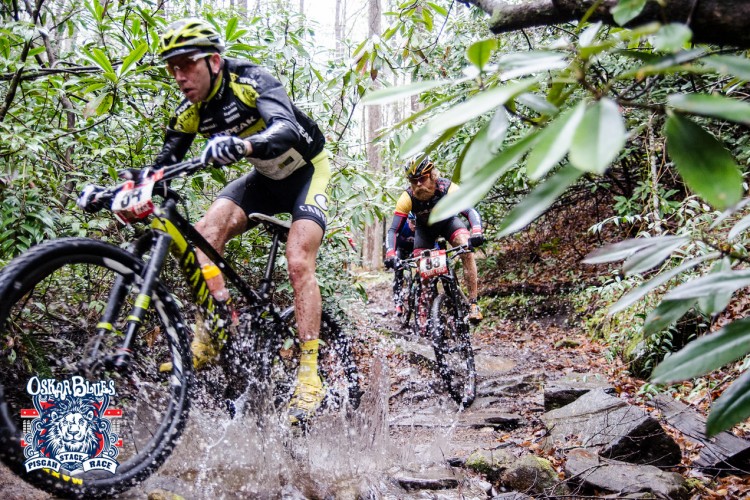

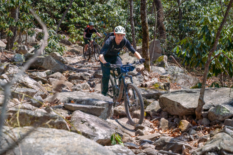
This is one of my all time favorite trails. We usually start this ride from the nearby Davidson River Campground (great place to camp), After crossing the highway, you have a LONG climb up Clawhammer which is a wide gravel fireroad, but it is steep in some sections and will take you awhile to reach the top (from the campground to the top is probably about 7-8 miles and takes ~ 45 minutes depending on skill level). After getting to the top, you now get to enjoy pushing your bike up the singletrack section of Black Mtn. for a mile or two. Maybe some can ride this section, but it is beyond my skill level. After the hike-a-bike section, you are rewarded for all that time climbing with some great technical downhill. The downhill sections are great because there is a little something for everyone. The first time on it, I walked some of the tougher sections, but that just gave me more motivation to return and try and clear it. Overall, this trail is definitely expert to intermediate level as the downhill section is fast and technical.
| ThankRode bottom section via Thrift Cove climb. 2 mile climb, 1st mile very difficult, some walking, but totally worth the reward connecting to Black Mt. So, fast, flowy and steep. Awesome downhill. This is a quick, 45 min loop. Add on Grassy Rd. and Sycamore Cove to extend ride.
| ThankAnother one of Pisgah's finest, though not for the faint of heart. Long fire road climb with a short hike-a-bike at the top followed by pretty technical and fast descent. Turn left at the bottom of the first long downhill section (forget the name of it) for some additional fast, jumpy downhill.
| ThankHello everyone.
| ThankI have been riding the Pisgah area since 1995. This is the best MTB riding in the southeastern United states. This trail area has a little bit of everything. However, most of the Pisgah trails are intermediate to expert. If you are looking for what MTBing was like in the good ol' days before banked corners, smooth trails and man made jumps this is your place. Yea, you will definitely find spots that are hike-a bike but the majority of the trails here are ridable. Laurel MTN, Black MTN, Avery Creek, Clawhammer Road, Bennetts Gap, Sycamore Cove, Buckhorn Gap, Cove Creek are all worth the time and the effort. Now, if you are looking for a MTB park experience this is NOT that kind of place. This is how MTBing use to be. I love this place.
I've only ridden the lower portion of Black Mountain but it's a blast! Fast and flowy in spots but also some good rocks and roots to show off those tech skills. Recent trail work has made some of the tricky parts less tricky.
| ThankThis trail is not for anyhing but expert DownHill riders. 70% of the climbs are unridedable unless you are a Demon. You spend most of the time pushing bike up. The first descend is good. Then you get some descend suitable only for DownHill experts. This is not a trail for a nice intermediate-advance ride. Its purely expert and some parts
| ThankAre extremely. We had to walk down significantly since the drops were way too dangerous. If you are not a DH expert: avoid this trail. Its great for tought hike though.
This trail is not for anyhing but expert DownHill riders. 70% of the climbs are unridedable unless you are a Demon. You spend most of the time pushing bike up. The first descend is good. Then you get some descend suitable only for DownHill experts. This is not a trail for a nice intermediate-advance ride. Its purely expert and some parts
| ThankAre extremely. We had to walk down significantly since the drops were way too dangerous. If you are not a DH expert: avoid this trail. Its great for tought hike though.
Very hard climb that took me forever but the downhill back was unreal! Loved every second of the punishment and the reward!!!
| ThankYou start with climbing...which seems to last forever...until you reach the top...then you BOMB. Lots of fun.
| ThankI only rode lower Black Mountain but Yes! loved it. fast, flowy, technical. Would recommend this. I wish I had ridden the entire trail, up and down. Gives me reason to travel back to Pisgah someday.
| ThankExtremely demanding, equally rewarding. No matter how many times you read "It's worth it!", you'll have some doubts when the seven mile fire road climb turns into brutal hike-a-bike. But the descent is amazing. The top half is littered with deep ruts, water bars and basketball sized rocks, followed by a joyful, flowy roller coaster to the bottom.
Black Mountain is very technical and truly scary at times. Long strings of three foot drops separated by washed out roots and loose stones. Definitely pushed me way outside my comfort zone.
| ThankSome of the sickest downhill trails I've had the chance to ride. Long climb on the gravel road and some hike-a-bike the last 1.5mi definitely had me wondering if all the talk about this trail was worth it. When I finished the top section of Black mtn I had that answer, a resounding yes!! Lots of technical rocks, ruts, drops and roots. The 2nd section of downhill was much of the same. The lower section was a blast of flowing, fast, jumping and off camber trail. Thoroughly enjoyed blasting down this trail and will explore much more of Pisgah the next trip up.
| ThankVery tough. The climb is doable (though it's a category 2). The top is rough so it's hard to get any speed up on the downhill. You'll be exhausted after the climb and it can be frustrating trying to maneuver over the rocks/roots going downhill. However, after a bit the trail clears and it's one of the best descents you'll ever do. Not for beginners...or intermediates either. You really have to know what you're doing to enjoy this trail.
| ThankCame up from Fla and went to sycamore cycles who hooked me up with a great bike and said got black mountain trail of you want a piscagh ride so I did. Amazing! Thought I was over my head when I got in to the climbs. No amount of training in Fla could get you ready for that. But once I reach the summit my hiking and efforts were rewarded. Amazing technical downhill. Keep your eyes ahead pick a line and rip it. This is was true mtb is and I thank the guys a sycamore for putting me on a rig that could handle it. I highly recommend it.
| ThankINSANE, this is why Pisgah is my favorite east coast area to go mountain biking. Going up it's doable at the beginning followed by sporadic short hike a bike sections until you get some steeper grade. Coming down though, ooooh man! Those hike a bike sections turn into technical drop offs that keep your arms busy. It's all about finding a speedy line and quick decisions and the last part of the downhill turns pretty flowy with a few large berms. I can't wait to go back. Not for beginners, but I guess anyone going to Pisgah would already know what lies ahead of them!
| ThankGot to do trail. Everything Pisgah Forest has to offer.
| ThankLoved it
| ThankThis is what pisgah riding is all about, something for everyone. A good long climb, great views, epic downhill. Can be done on a hard tail but more fun on a full sus. My weekly loop starts at the ranger station to the riding stables, pick up clawhamer, right on blk mountain trail, cross straight over maxwell cove, stay on black, bomb. Youll reach the intersection of thrift and black, keep right on blk(watch out for hikers at this point, they have right of way, and they know it). When you get to the bottom of black make a left on thrift cove and climb to grassy road and make a hard left on sycomore cove, great little trail that will spit you out on 276. Would also recommend farlow gap to danial ridge. Make sure to stop at the hub for a pint of our local brews and great conversation!
| ThankI had no idea what I was in for on this trail, but the down was THE BOMB! And I had a hard tail! I thought I was lost a few times, but it was allll good.
| Thankafter stopping at the local bike shop for directions to the best downhill- i thought i was lost. after a long fireroad hill climb, and a right at the stairs through a 45 minute bike push through sage brush and cliffs, i reached the summit. i dropped my seat and commensed to destroy my triceps. the downhill is a great fast, multi waterbar launching singletrack. your body is screaminf for a break, your skills are overtasked, your bike is exceeding its limitiations and you dont want the rush to end!
| Thankall in all. the down is worth the up.